Difference between revisions of "Rima Messier"
| Line 6: | Line 6: | ||
|} | |} | ||
<div id="toc"> | <div id="toc"> | ||
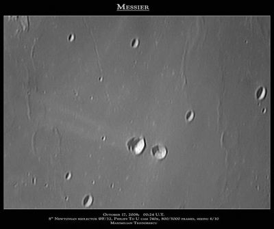
| − | [http://www.lpod.org/coppermine/albums/userpics/Messier_Max.jpg [[Image: | + | [http://www.lpod.org/coppermine/albums/userpics/Messier_Max.jpg [[Image:Normal_Messier_Max.jpg|external image normal_Messier_Max.jpg]]]<br /> ''[http://lpod.org/coppermine/displayimage.php?pos=-3799 Maximilian Teodorescu]'' [[Messier|Messier]] is the right-most crater of the pair near the center. '''Rimae Messier''' is seen as the thin gouge slanting up towards the top of the frame, intersecting the top margin about a third of the way from the left, between the craters '''[[Secchi|Secchi]] X''' (left) and '''[[Secchi|Secchi]] K''' (right).<br /> <br /> |
==Images== | ==Images== | ||
[http://www.lpod.org/coppermine/thumbnails.php?album=search&type=full&search=Rima%20Messier LPOD Photo Gallery] [http://www.lpi.usra.edu/resources/lunar_orbiter/bin/srch_nam.shtml?Rima%20Messier%7C0 Lunar Orbiter Images]<br /> <br /> | [http://www.lpod.org/coppermine/thumbnails.php?album=search&type=full&search=Rima%20Messier LPOD Photo Gallery] [http://www.lpi.usra.edu/resources/lunar_orbiter/bin/srch_nam.shtml?Rima%20Messier%7C0 Lunar Orbiter Images]<br /> <br /> | ||
Latest revision as of 02:11, 16 April 2018
Contents
Rima Messier
|
Lat: 1.0°S, Long: 45.0°E, Length: 100 km, Depth: km, Rükl 48 |

Maximilian Teodorescu Messier is the right-most crater of the pair near the center. Rimae Messier is seen as the thin gouge slanting up towards the top of the frame, intersecting the top margin about a third of the way from the left, between the craters Secchi X (left) and Secchi K (right).
Images
LPOD Photo Gallery Lunar Orbiter Images
Maps
(LAC zone 79B1) LAC map Geologic map AIC map LTO map
Description
Description: Wikipedia
Additional Information
Nomenclature
- Named after the nearby crater (Messier).
- The original IAU nomenclature of Named Lunar Formations (1935) included a feature called Messier Ir (Catalog No. 4260, with "r" for "rille) which is actually a 60-70 km wrinkle ridge centered at around 5.1°S/45.4°E -- to the southwest of the Messier pair -- mis-plotted as a rille on the maps of Neison, 1876, whose work greatly influenced the IAU name selections. The Messier Ir of Named Lunar Formations was a little north of the cluster of peaks in Mare Fecunditatis then known as Messier Alpha (6.0°S/45.2°E), but now also unnamed.
- On the maps of the System of Lunar Craters the name Messier I was recycled to the present, unrelated feature. The new designation appears on Sheet A5, although the rille is neither plotted nor labeled on Sheet A4. It is well drawn on the somewhat contemporaneous LAC 79 (April 1963), but labeled (as Rima Messier I) only on AIC 79B (December 1966).
- Although the name applies to a single rille, rather than a system, the correct designation became uncertain when, in 1973, the IAU declared "Rimae and Rima systems will receive new and more appropriate designations."
- LTO 79B1 (August 1974) suggested the name Fossa Messier, a designation ultimately rejected by the IAU.
- The new designation Rima Messier (without the "I") presumably first appeared in the database prepared for the first print editions of the IAU Planetary Gazetteer.
LPOD Articles
Bibliography