Difference between revisions of "Brouwer"
| Line 5: | Line 5: | ||
|- | |- | ||
| | | | ||
| − | [http://lpod.org/coppermine/displayimage.php?pid=4212&fullsize=1 [[Image: | + | [http://lpod.org/coppermine/displayimage.php?pid=4212&fullsize=1 [[Image:Normal_brouwer-large.jpg|external image normal_brouwer-large.jpg]]]<br /> |
| | | | ||
| − | [[Image: | + | [[Image:Brouwer-color.jpg|brouwer-color.jpg]]<br /> |
|} | |} | ||
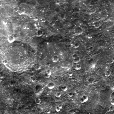
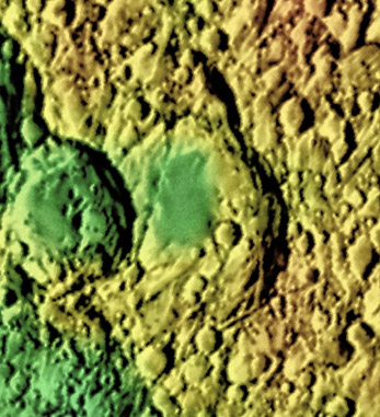
'''Left:''' [http://pdsmaps.wr.usgs.gov/explorer-bin/mapmars4.cgi?WHEREFROM=COLOR&VERSION=INTERMEDIATE&DATA_SET_NAME=moon_clementine_bw&PIXEL_TYPE=BIT8&SCALE=pixels/degree&PROJECTION=SINUSOIDAL&RESOLUTION=64&RESAMP_METHOD=NEAREST_NEIGHBOR&BANDS_SELECTED=&FORMAT=JPEG&LONBOX=16&LATBOX=16&GRIDLINE_FREQUENCY=none&STRETCH=NONE&LAT=-39&LON=232.5&LINE=1024&SAMP=878 Clementine] image from [http://pdsmaps.wr.usgs.gov/PDS/public/explorer/html/lidrintm.htm PDS Map-A-Planet]. '''Right:''' [http://planetarynames.wr.usgs.gov/images/Lunar/lac_122.pdf Colo-coded Lac 122] from [[USGS%20Digital%20Atlas|USGS Digital Atlas]]<br /> <div id="toc"> | '''Left:''' [http://pdsmaps.wr.usgs.gov/explorer-bin/mapmars4.cgi?WHEREFROM=COLOR&VERSION=INTERMEDIATE&DATA_SET_NAME=moon_clementine_bw&PIXEL_TYPE=BIT8&SCALE=pixels/degree&PROJECTION=SINUSOIDAL&RESOLUTION=64&RESAMP_METHOD=NEAREST_NEIGHBOR&BANDS_SELECTED=&FORMAT=JPEG&LONBOX=16&LATBOX=16&GRIDLINE_FREQUENCY=none&STRETCH=NONE&LAT=-39&LON=232.5&LINE=1024&SAMP=878 Clementine] image from [http://pdsmaps.wr.usgs.gov/PDS/public/explorer/html/lidrintm.htm PDS Map-A-Planet]. '''Right:''' [http://planetarynames.wr.usgs.gov/images/Lunar/lac_122.pdf Colo-coded Lac 122] from [[USGS%20Digital%20Atlas|USGS Digital Atlas]]<br /> <div id="toc"> | ||
Revision as of 01:43, 16 April 2018
Contents
Brouwer
| Lat: 36.2°S, Long: 126.0°W, Diam: 158 km, Depth: km, Rükl: (farside) | |
Images
LPOD Photo Gallery Lunar Orbiter Images
Frame 20, made by ZOND 8, shows Brouwer just "below" the black disc near the frame's right margin.
Research: Danny Caes
Maps
(LAC zone 122A3) USGS Digital Atlas PDF
Description
Brouwer is a crater of the Nectarian period (~ 3.92 to 3.85 bn years) and lies just off the north-eastern sector of the South Pole Aitken Basin -- a 2500 kilometre-wide basin of the pre-Nectarian period (~ 4.6 to 3.92 bn years). The rim of Brouwer is barely perceptible in the above image as most of it is well worn down through age and through minor impacts, however, its old appearance and impercibility, undoubtedly, also pays tribute to influence from ejecta deposits from the Orientale Basin -- a basin of the Imbrium period (3.85 - 3.15 bn years) -- lying just north-east of the crater. Rim-collapsed material has filled most of the eastern floor of Brouwer, while its western sector has been interrupted by a major impact producing Langmuir crater. For a complex crater having an approximate diameter of 158 km, Brouwer's central region lacks a peak, however, would the crater (~ 25 km) at the centre of the floor be responsble for obliteration of this missing peak?- JohnMoore2 JohnMoore2
Description: Wikipedia
Additional Information
Nomenclature
- Dirk Brouwer (9/1/1902 – 1/31/1966) was a Dutch-American astronomer. From 1941 until 1966 he was editor of the Astronomical Journal. He specialized in celestial mechanics and together with Gerald Clemence wrote the textbook Methods of Celestial Mechanics.
- Luitzen Egbertus Jan Brouwer (2/27/1881 - 12/2/1966) was a Dutch mathematician and philosopher who worked in topology, set theory, measure theory and complex analysis.
LPOD Articles
Bibliography

