Difference between revisions of "Gardner Megadome"
| Line 6: | Line 6: | ||
|} | |} | ||
<div id="toc"> | <div id="toc"> | ||
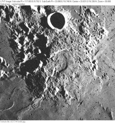
| − | + | [http://www.lpod.org/coppermine/albums/userpics/Gardner-Megadome_AS17-M-0306_LTVT.JPG [[Image:normal_Gardner-Megadome_AS17-M-0306_LTVT.JPG|external image normal_Gardner-Megadome_AS17-M-0306_LTVT.JPG]]]<br /> ''[http://lpod.org/coppermine/displayimage.php?pos=-2920 AS17-M-0306]'' The “megadome” is the large elevated area in the center of this frame (to the south of 18-km [[Gardner|Gardner]] at top center). The 22-km depressed area at dead center (speculated to be a volcanic caldera in the [http://www2.lpod.org/wiki/September_26,_2004 LPOD]) is '''[[Vitruvius|Vitruvius]] H'''. Directly to its west (left), is 18-km '''[[Vitruvius|Vitruvius]] B''' (with long shadows hiding the floor); and, to its north (midway to [[Gardner|Gardner]]) 18-km '''[[Vitruvius|Vitruvius]] T'''. On the right, the sunlit eastern edge of the megadome is regarded as part of the west rim of the flooded 67-km crater '''[[Maraldi|Maraldi]] D'''. In the lower left corner, the ridge extending out of the megadome is possibly regarded as part of [[Dorsa%20Barlow|Dorsa Barlow]]. The odd pancake-shaped feature partially visible to its west (cut by the left margin) is unnamed.<br /> <br /> | |
| − | |||
==Images== | ==Images== | ||
[http://www.lpod.org/coppermine/thumbnails.php?album=search&type=full&search=Gardner LPOD Photo Gallery] [http://www.lpi.usra.edu/resources/lunar_orbiter/bin/srch_nam.shtml?Gardner%7C0 Lunar Orbiter Images] [http://www.lpi.usra.edu/resources/apollo/search/feature/?feature=Gardner Apollo Images]<br /> <br /> | [http://www.lpod.org/coppermine/thumbnails.php?album=search&type=full&search=Gardner LPOD Photo Gallery] [http://www.lpi.usra.edu/resources/lunar_orbiter/bin/srch_nam.shtml?Gardner%7C0 Lunar Orbiter Images] [http://www.lpi.usra.edu/resources/apollo/search/feature/?feature=Gardner Apollo Images]<br /> <br /> | ||
| Line 30: | Line 29: | ||
A.J.M.Wanders; ''Op Ontdekking in het Maanland'' (Het Spectrum, 1949).<br /> <br /> | A.J.M.Wanders; ''Op Ontdekking in het Maanland'' (Het Spectrum, 1949).<br /> <br /> | ||
---- | ---- | ||
| − | + | </div> | |
Revision as of 16:23, 15 April 2018
Contents
Gardner Megadome
(unofficial name)
| Lat: 16.61°N, Long: 35.56°E, Diam: 60.9 km, Height: 0.975 km, Rükl: 25 |
AS17-M-0306 The “megadome” is the large elevated area in the center of this frame (to the south of 18-km Gardner at top center). The 22-km depressed area at dead center (speculated to be a volcanic caldera in the LPOD) is Vitruvius H. Directly to its west (left), is 18-km Vitruvius B (with long shadows hiding the floor); and, to its north (midway to Gardner) 18-km Vitruvius T. On the right, the sunlit eastern edge of the megadome is regarded as part of the west rim of the flooded 67-km crater Maraldi D. In the lower left corner, the ridge extending out of the megadome is possibly regarded as part of Dorsa Barlow. The odd pancake-shaped feature partially visible to its west (cut by the left margin) is unnamed.
Images
LPOD Photo Gallery Lunar Orbiter Images Apollo Images
Maps
(LAC zone 43D4) LAC map Geologic map LTO map
Description
Description: Wikipedia
Additional Information
- Position and diameter are from the GLR Dome Catalog.
Nomenclature
- Named for nearby crater (Gardner).
- Before this formation was called Gardner Megadome, it was called "f" (thus printed in Figure 115 on page 301 of the Dutch book Op Ontdekking in het Maanland by A.J.M.Wanders).
- From pages 301-302 in the book Op Ontdekking in het Maanland (A.J.M.Wanders):
Recht boven Littrow bevindt zich, vlak bij Mons Argaeus, de ringberg Vitruvius. Links daaronder de vreemde, donkere, halvemaanvormige Maraldi, en recht boven deze, in het derde hoekpunt van een gelijkzijdige driehoek met Maraldi en Vitruvius, een van de eigenaardigste maanobjekten, dat geen naam en zelfs geen letter draagt. Het is een bult-achtige verhevenheid, ongeveer zo groot als Eudoxus, d.w.z. 70 kilometer. Op figuur 115 vindt ge hem door een stippellijn omgrensd. Wilt ge deze bult te zien krijgen, dan moet ge vier dagen na Volle Maan dit landschap bekijken. Hij werpt dan een duidelijke schaduw naar links en ge zult U verwonderen over de naamloosheid van deze dan opvallende bijzonderheid. Op onze foto van het Eerste Kwartier is hij als verhevenheid niet zichtbaar meer, daarvoor is de lichtgrens reeds te ver. Het objekt behoort tot de veronderstelde categorie "maankraters in wording", zoals Loewy en Puiseux zich deze met hun "blazentheorie" tenminste dachten (blz. 165). Plaatselijke concentraties van vulkanische gassen onder de oppervlakte zouden de korst hebben omhooggedrukt, deze zou daarna zijn opengebarsten, waarna aan een maankrater het aanzijn gegeven was. - Ofschoon deze zienswijze later als vormingsmechanisme-in-het-algemeen werd opgegeven, is het toch best mogelijk dat een koepelvormige opbolling, zoals hier te bespeuren, - en waarvan er op nog enkele plaatsen (Rumker bijvoorbeeld) op de maan voorkomen - aan de beschreven oorzaak van ondergrondse gaswerking zijn ontstaan te danken heeft.
Note: the sketch from Wanders (Figure 115, page 301) of the eastern "coastline" of Mare Serenitatis, which also shows the location of the Gardner Megadome or "f", as seen in a common telescope (lunar north downward, south upward) is not included here.
LPOD Articles
Astonishing Megadome
Quantified Mountain
Bibliography
A.J.M.Wanders; Op Ontdekking in het Maanland (Het Spectrum, 1949).
