Difference between revisions of "Eimmart"
| Line 6: | Line 6: | ||
|} | |} | ||
<div id="toc"> | <div id="toc"> | ||
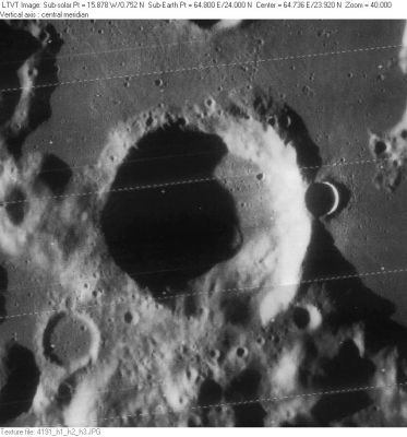
| − | + | [http://www.lpod.org/coppermine/albums/userpics/Eimmart_LO-IV-191H_LTVT.JPG [[Image:normal_Eimmart_LO-IV-191H_LTVT.JPG|external image normal_Eimmart_LO-IV-191H_LTVT.JPG]]]<br /> ''[http://lpod.org/coppermine/displayimage.php?pos=-2712 LO-IV-191H]'' The 7-km crater on the east rim is '''Eimmart A'''. A small piece of 14-km '''Eimmart G''' is visible along the top margin.<br /> <br /> | |
| − | |||
==Images== | ==Images== | ||
[http://www.lpod.org/coppermine/thumbnails.php?album=search&type=full&search=Eimmart LPOD Photo Gallery] [http://www.lpi.usra.edu/resources/lunar_orbiter/bin/srch_nam.shtml?Eimmart%7C0 Lunar Orbiter Images] [http://www.lpi.usra.edu/resources/apollo/search/feature/?feature=Eimmart Apollo Images]<br /> <br /> | [http://www.lpod.org/coppermine/thumbnails.php?album=search&type=full&search=Eimmart LPOD Photo Gallery] [http://www.lpi.usra.edu/resources/lunar_orbiter/bin/srch_nam.shtml?Eimmart%7C0 Lunar Orbiter Images] [http://www.lpi.usra.edu/resources/apollo/search/feature/?feature=Eimmart Apollo Images]<br /> <br /> | ||
| Line 23: | Line 22: | ||
** Westfall, 2000: 1.56 km | ** Westfall, 2000: 1.56 km | ||
** Cherrington, 1969: 3.47 km | ** Cherrington, 1969: 3.47 km | ||
| − | * From the shadows in [http://www.lpi.usra.edu/resources/lunarorbiter/frame/?4191 LO-IV-191H], '''Eimmart''' is 3200-4400 m deep. <span class="membersnap">- | + | * From the shadows in [http://www.lpi.usra.edu/resources/lunarorbiter/frame/?4191 LO-IV-191H], '''Eimmart''' is 3200-4400 m deep. <span class="membersnap">- Jim Mosher</span> |
| − | * '''Eimmart A''', the high-albedo raycrater at the eastern part of '''Eimmart''''s rim, has an extremely large chunk of rocky outcrop at the southern part of its inner slopes. The length of this chunk is about half a kilometer! The pinpoint coordinates of '''Eimmart A''' are: '''LON 65.71 / LAT 24.09''' on the LRO's [http://target.lroc.asu.edu/da/qmap.html ACT-REACT Quick Map]. <span class="membersnap">- | + | * '''Eimmart A''', the high-albedo raycrater at the eastern part of '''Eimmart''''s rim, has an extremely large chunk of rocky outcrop at the southern part of its inner slopes. The length of this chunk is about half a kilometer! The pinpoint coordinates of '''Eimmart A''' are: '''LON 65.71 / LAT 24.09''' on the LRO's [http://target.lroc.asu.edu/da/qmap.html ACT-REACT Quick Map]. <span class="membersnap">- DannyCaes <small>Jun 26, 2011</small></span> |
<br /> | <br /> | ||
==Change in a Lunar Crater (Eimmart)== | ==Change in a Lunar Crater (Eimmart)== | ||
| Line 51: | Line 50: | ||
[http://the-moon.us/wiki/Alphabetical%20Index Named Featues] -- Prev: [http://the-moon.us/wiki/Eijkman Eijkman] -- Next: [http://the-moon.us/wiki/Einstein Einstein]<br /> | [http://the-moon.us/wiki/Alphabetical%20Index Named Featues] -- Prev: [http://the-moon.us/wiki/Eijkman Eijkman] -- Next: [http://the-moon.us/wiki/Einstein Einstein]<br /> | ||
---- | ---- | ||
| − | + | </div> | |
Revision as of 16:21, 15 April 2018
Contents
Eimmart
|
Lat: 23.93°N, Long: 64.77°E, Diam: 45.46 km, Depth: 1.56 km, Rükl: 27 |
LO-IV-191H The 7-km crater on the east rim is Eimmart A. A small piece of 14-km Eimmart G is visible along the top margin.
Images
LPOD Photo Gallery Lunar Orbiter Images Apollo Images
Maps
(LAC zone 44C1) LAC map Geologic map
Description
Elger
(IAU Directions) EIMMART.--A conspicuous ring-plain with bright walls on the N.E. margin of the Mare Crisium. The W. border attains a height of 10,000 feet above the interior, which, according to Schmidt, has a small central mountain. There is a rill-like valley on the W. of the formation.
Wikipedia
Additional Information
- IAU page: Eimmart
- Depth data from Kurt Fisher database
- Westfall, 2000: 1.56 km
- Cherrington, 1969: 3.47 km
- From the shadows in LO-IV-191H, Eimmart is 3200-4400 m deep. - Jim Mosher
- Eimmart A, the high-albedo raycrater at the eastern part of Eimmart's rim, has an extremely large chunk of rocky outcrop at the southern part of its inner slopes. The length of this chunk is about half a kilometer! The pinpoint coordinates of Eimmart A are: LON 65.71 / LAT 24.09 on the LRO's ACT-REACT Quick Map. - DannyCaes Jun 26, 2011
Change in a Lunar Crater (Eimmart)
Source: W.R.Corliss's Mysterious Universe; a handbook of astronomical anomalies (1979), pages 201-202.
  (Anonymous, American Journal of Science, 4:38:95, 1914)

  Most, if not all, of the changes which have been observed on the moon and accepted as thoroughly verified are of a periodic nature. A marked case of non-periodic change is recorded in a short article by William H. Pickering. The author says: "It is indeed the most marked non-periodic change that the writer has ever detected". The crater in question is named Eimmart and is situated at the northeast border of Mare Crisium, in latitude 24° and longitude 295°. This crater is about 40 KM in diameter. The general nature of the phenomenon observed is that while formerly, at each lunation, the crater apparently filled up gradually and overflowed with a white material, the source of which was a point at the foot of the northern interior slope, this change no longer occurs. The last "eruption" observed occurred in January, 1913. Only one observation was made in February and March, but less activity was then shown, while in April and May the phenomenon was so reduced in intensity as to be scarcely noticeable. Interesting drawings of the appearance of the crater during and after its maximum activity are reproduced in the paper, but the author does not discuss the geological or physical aspects of the results obtained with the Draper refractor.
  - Astronomische Nachrichten, N° 4704, P. 414.
Nomenclature
- Named for Georg Christoph Eimmart (1638-1705) artist, astronomer and engraver. Eimmart, who was a student of Weigel, set up an academy of painting in Nuremberg, and later, in the castle, founded an astronomical observatory. Several persons associated with that observatory are also honored with crater names. More about Eimmart (in German).
- Exhibitof Eimmart map.
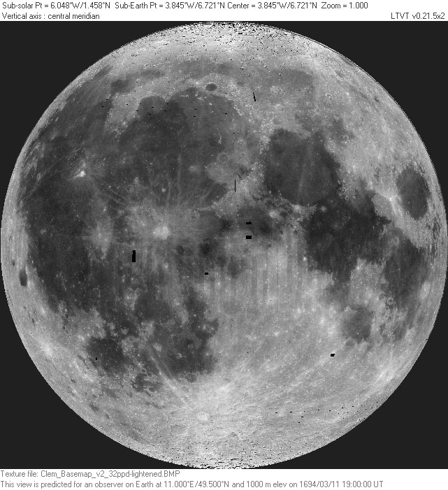
- Lunar map engraved by G. C. Eimmart, representing Full Moonof March 11, 1694, used in book by Johann Zahn.
- A number of lunar images are also attributed to Eimmart's daughter Maria Clara(1676-1707), who reportedly made hundreds of drawings of lunar phases:
- Illustrations of celestial phenomenaat the University of Bologna. The pastel painting shown appears identical, including its odd geometric distortions, to the G. C. Eimmart map engraving, and is perhaps the drawing on which the map is based?
- Additional image attributed to Maria Clara Eimmart (note: the date written on the image is erroneous -- the gibbous Moon would have been nearly full on August 29, 1697).
- List of lunar craters named for Nuremberg astronomers.
- According to Whitaker (p. 218), this name was introduced by Schröter.
- Eimmart C, a crater attached to the northeastern rim of Mare Crisium, was called Cooke by Wilkins and Moore, but the I.A.U. did not accept that name. Cooke was an English amateur astronomer.
- Eimmart T was called "Schwanzende" by Julius Heinrich Franz. His alternative name is mentioned in the IAU's Named Lunar Formations.
- The LROC-team seems to know crater Eimmart A as "Dart A", see LROC RDR Product NAC-Anaglyph: Dart A Floor Melt.
- Eimmart K isles (a nickname from D.Caes for the cluster of small hillocks south-southwest of Eimmart K, on the most eastern section of Mare Crisium).
LPOD Articles
Bibliography
- Change in a Lunar Crater (Eimmart): American Journal of Science, 4:38:95, 1914 (see also page 201 of W.R.Corliss's Mysterious Universe; a Handbook of Astronomical Anomalies, The Sourcebook Project, 1979).
Named Featues -- Prev: Eijkman -- Next: Einstein

