Difference between revisions of "Burckhardt"
| Line 6: | Line 6: | ||
|} | |} | ||
<div id="toc"> | <div id="toc"> | ||
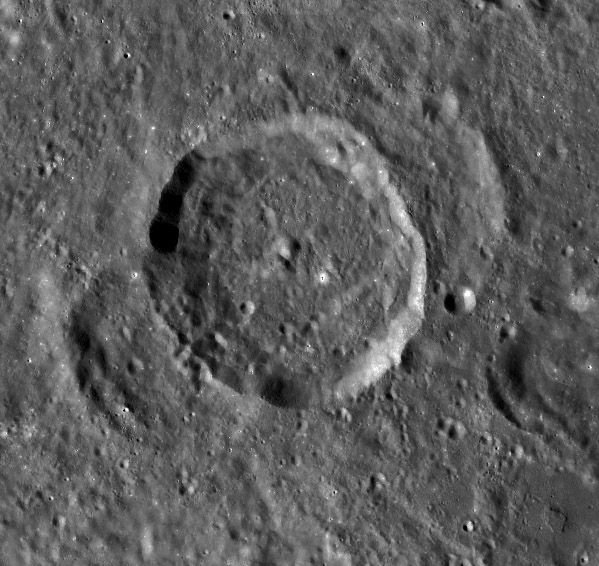
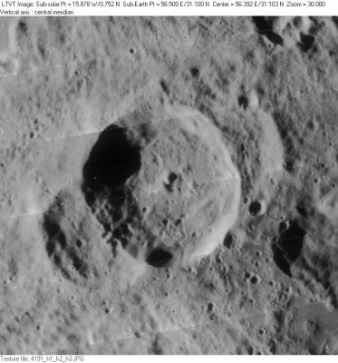
| − | + | [http://www.lpod.org/coppermine/albums/userpics/Burckhardt_LO-IV-191H_LTVT.JPG [[Image:normal_Burckhardt_LO-IV-191H_LTVT.JPG|external image normal_Burckhardt_LO-IV-191H_LTVT.JPG]]][[Image:Burckhart-LRO.jpg|Burckhart-LRO.jpg]]<br /> ''[http://lpod.org/coppermine/displayimage.php?pos=-3521 LO-IV-191H]'' (left) '''Burckhardt''' is in the center, overlaying two older, but smaller, craters knowns as '''Burckhardt E''' (lower left "ear") and '''Burckhardt F''' (upper right "ear"). Right is from [http://wms.lroc.asu.edu/lroc#damoon LRO WAC mosaic.]<br /> <br /> | |
| − | |||
==Images== | ==Images== | ||
[http://www.lpod.org/coppermine/thumbnails.php?album=search&type=full&search=Burckhardt LPOD Photo Gallery] [http://www.lpi.usra.edu/resources/lunar_orbiter/bin/srch_nam.shtml?Burckhardt%7C0 Lunar Orbiter Images]<br /> <br /> | [http://www.lpod.org/coppermine/thumbnails.php?album=search&type=full&search=Burckhardt LPOD Photo Gallery] [http://www.lpi.usra.edu/resources/lunar_orbiter/bin/srch_nam.shtml?Burckhardt%7C0 Lunar Orbiter Images]<br /> <br /> | ||
| Line 23: | Line 22: | ||
** Viscardy, 1985: 4.84 km | ** Viscardy, 1985: 4.84 km | ||
** Cherrington, 1969: 4.84 km | ** Cherrington, 1969: 4.84 km | ||
| − | * The long shadow in [http://www.lpi.usra.edu/resources/lunarorbiter/frame/?4191 LO-IV-191H] indicates height differences of up to about 5000 m between parts of the northwest rim and the floor. The few available Earth-based photos with lighting from the east ([http://www.pbase.com/image/78639969 example] by Bob Pilz) suggest considerably smaller depths, but the shadows in those cases originate on the southeast rim and terminate on the rubble pile at its foot -- so they don't measure the full depth. <span class="membersnap">- | + | * The long shadow in [http://www.lpi.usra.edu/resources/lunarorbiter/frame/?4191 LO-IV-191H] indicates height differences of up to about 5000 m between parts of the northwest rim and the floor. The few available Earth-based photos with lighting from the east ([http://www.pbase.com/image/78639969 example] by Bob Pilz) suggest considerably smaller depths, but the shadows in those cases originate on the southeast rim and terminate on the rubble pile at its foot -- so they don't measure the full depth. <span class="membersnap">- Jim Mosher</span> |
* Central peak height | * Central peak height | ||
** [[Sekiguchi%2C%201972|Sekiguchi, 1972]]: | ** [[Sekiguchi%2C%201972|Sekiguchi, 1972]]: | ||
*** an oblong hill on the west part of the floor: 0.58 km | *** an oblong hill on the west part of the floor: 0.58 km | ||
*** a low mountain block on the south part of the floor: 0.6 km <span class="membersnap">- [http://www.wikispaces.com/user/view/fatastronomer [[Image:fatastronomer-lg.jpg|16px|fatastronomer]]] [http://www.wikispaces.com/user/view/fatastronomer fatastronomer]</span> | *** a low mountain block on the south part of the floor: 0.6 km <span class="membersnap">- [http://www.wikispaces.com/user/view/fatastronomer [[Image:fatastronomer-lg.jpg|16px|fatastronomer]]] [http://www.wikispaces.com/user/view/fatastronomer fatastronomer]</span> | ||
| − | * Since the size of objects impacting the Moon is thought to have generally decreased with time, the existence of a relatively fresh large crater overlying older, smaller ones is regarded as somewhat rare. <span class="membersnap">- | + | * Since the size of objects impacting the Moon is thought to have generally decreased with time, the existence of a relatively fresh large crater overlying older, smaller ones is regarded as somewhat rare. <span class="membersnap">- Jim Mosher</span> |
<br /> | <br /> | ||
==Nomenclature== | ==Nomenclature== | ||
| Line 41: | Line 40: | ||
<br /> <br /> | <br /> <br /> | ||
---- | ---- | ||
| − | + | </div> | |
Revision as of 16:16, 15 April 2018
Contents
Burckhardt (the crater with "ears")
|
Lat: 31.1°N, Long: 56.5°E, Diam: 56 km, Depth: 5.92 km, Rükl: 16 |

LO-IV-191H (left) Burckhardt is in the center, overlaying two older, but smaller, craters knowns as Burckhardt E (lower left "ear") and Burckhardt F (upper right "ear"). Right is from LRO WAC mosaic.
Images
LPOD Photo Gallery Lunar Orbiter Images
Maps
(LAC zone 44A2) LAC map Geologic map
Description
Description: Elger
(IAU Directions) BURCKHARDT.--This object, situated on an apparent extension of the E. wall of Cleomedes, is 35 miles in diameter, with a lofty border, rising on the W. to an altitude of nearly 13,000 feet. It has a prominent central mountain and some low ridges on the floor, which, together with two minute craters on the S.E. wall, I have seen under a low angle of morning illumination. It is flanked both on the W. and E. by deep irregular depressions, which present the appearance of having once been complete formations.
Description: Wikipedia
Additional Information
- Depth data from Kurt Fisher database
- Westfall, 2000: 5.92 km
- Viscardy, 1985: 4.84 km
- Cherrington, 1969: 4.84 km
- The long shadow in LO-IV-191H indicates height differences of up to about 5000 m between parts of the northwest rim and the floor. The few available Earth-based photos with lighting from the east (example by Bob Pilz) suggest considerably smaller depths, but the shadows in those cases originate on the southeast rim and terminate on the rubble pile at its foot -- so they don't measure the full depth. - Jim Mosher
- Central peak height
- Sekiguchi, 1972:
- an oblong hill on the west part of the floor: 0.58 km
- a low mountain block on the south part of the floor: 0.6 km - fatastronomer fatastronomer
- Sekiguchi, 1972:
- Since the size of objects impacting the Moon is thought to have generally decreased with time, the existence of a relatively fresh large crater overlying older, smaller ones is regarded as somewhat rare. - Jim Mosher
Nomenclature
- Named for Johann Karl Burckhardt (April 30, 1773 - June 22, 1825), a German-born astronomer and mathematician who later became a naturalized French citizen. Between 1812 and 1825, he published Tables de la Lune, a lunar ephemeris that was calculated using a different technique from that established by Pierre-Simon Laplace. These were in turn superseded by the more accurate tables of John Couch Adams in 1852.
- This name was part of the original IAU nomenclature of Named Lunar Formations (1935).
- According to Whitaker (p. 219) the present name was introduced by Mädler. The same feature had been labeled as Barreae by van Langren (p. 195), and as part of Montes Riphaei by Hevelius (p. 207).
LPOD Articles
The Northern Moat
Cleo 3 (Cleomedes and Burckhardt, by Leo Aerts)
Bibliography
