Difference between revisions of "Vlacq"
| Line 3: | Line 3: | ||
{| class="wiki_table" | {| class="wiki_table" | ||
| | | | ||
| − | Lat: 53.3°S, Long: 38.8°E, Diam: 89 km, Depth: 3.83 km, [ | + | Lat: 53.3°S, Long: 38.8°E, Diam: 89 km, Depth: 3.83 km, [[R%C3%BCkl%2075|Rükl: 75]], pre-Nectarian<br /> |
|} | |} | ||
<div id="toc"> | <div id="toc"> | ||
| Line 11: | Line 11: | ||
[http://www.lpod.org/coppermine/thumbnails.php?album=search&type=full&search=Vlacq LPOD Photo Gallery] [http://www.lpi.usra.edu/resources/lunar_orbiter/bin/srch_nam.shtml?Vlacq%7C0 Lunar Orbiter Images] [http://www.lpi.usra.edu/resources/apollo/search/feature/?feature=Vlacq Apollo Images]<br /> <br /> | [http://www.lpod.org/coppermine/thumbnails.php?album=search&type=full&search=Vlacq LPOD Photo Gallery] [http://www.lpi.usra.edu/resources/lunar_orbiter/bin/srch_nam.shtml?Vlacq%7C0 Lunar Orbiter Images] [http://www.lpi.usra.edu/resources/apollo/search/feature/?feature=Vlacq Apollo Images]<br /> <br /> | ||
==Maps== | ==Maps== | ||
| − | ''([ | + | ''([[LAC%20zone|LAC zone]] 127B3)'' [http://www.lpi.usra.edu/resources/mapcatalog/LAC/lac127/ LAC map] [http://www.lpi.usra.edu/resources/mapcatalog/usgs/I702/ Geologic map]<br /> <br /> |
==Description== | ==Description== | ||
<br /> | <br /> | ||
==Description: Elger== | ==Description: Elger== | ||
| − | ''([ | + | ''([[IAU%20Directions|IAU Directions]])'' VLACQ.--A member of a magnificent group of closely associated formations situated on the greatly disturbed area between E. long. 30 deg. and 45 deg. and S. lat. 50 deg. and 60 deg. It is 57 miles in diameter, and is enclosed by terraced walls, rising on the E. about 8,000 feet, and on the W. more than 10,000 feet above the floor. They are broken on the S. by a fine crater. In addition to a conspicuous central peak, there are several small craters, and low short ridges in the interior.<br /> <br /> |
==Description: Wikipedia== | ==Description: Wikipedia== | ||
[http://en.wikipedia.org/wiki/Vlacq_%28crater%29 Vlacq]<br /> <br /> | [http://en.wikipedia.org/wiki/Vlacq_%28crater%29 Vlacq]<br /> <br /> | ||
==Additional Information== | ==Additional Information== | ||
| − | * Depth data from [ | + | * Depth data from [[Kurt%20Fisher%20crater%20depths|Kurt Fisher database]] |
** Westfall, 2000: 3.83 km | ** Westfall, 2000: 3.83 km | ||
** Viscardy, 1985: 3 km | ** Viscardy, 1985: 3 km | ||
** Cherrington, 1969: 1.18 km | ** Cherrington, 1969: 1.18 km | ||
| − | * [ | + | * [[Central%20peak%20composition|Central peak composition]]: A ([[Tompkins%20%26%20Pieters%2C%201999|Tompkins & Pieters, 1999]]) |
| − | * Vlacq and its satellite crater A are on the [ | + | * Vlacq and its satellite crater A are on the [[ALPO%20list%20of%20bright%20ray%20craters|ALPO list of bright ray craters]] |
==Nomenclature== | ==Nomenclature== | ||
* Named for [http://en.wikipedia.org/wiki/Adriaan_Vlacq Adriaan Vlacq] (1600-1667), a Dutch book publisher and mathematician. Vlacq published a table of Henry Briggs' logarithms from 1 to 100,000 to 10 decimal places in 1628 in his ''Arithmetica logarithmica''. | * Named for [http://en.wikipedia.org/wiki/Adriaan_Vlacq Adriaan Vlacq] (1600-1667), a Dutch book publisher and mathematician. Vlacq published a table of Henry Briggs' logarithms from 1 to 100,000 to 10 decimal places in 1628 in his ''Arithmetica logarithmica''. | ||
| − | * According to ''[ | + | * According to ''[[Whitaker|Whitaker]]'' (p. 214), this feature was labeled [[Pitiscus|Pitiscus]] on [[Riccioli|Riccioli]]'s map. The usage of the name '''Vlacq''' for the present feature was introduced by [[M%C3%A4dler|Mädler]], although the same person had been honored earlier by [[Langrenus|Van Langren]] (with the spelling '''Vlacci''' and the name assigned to the feature now known as [[Capella|Capella]]) (''[[Whitaker|Whitaker]]'', pp. 219-220). |
<br /> | <br /> | ||
==LPOD Articles== | ==LPOD Articles== | ||
Revision as of 15:21, 15 April 2018
Contents
Vlacq
|
Lat: 53.3°S, Long: 38.8°E, Diam: 89 km, Depth: 3.83 km, Rükl: 75, pre-Nectarian |
Table of Contents
[#Vlacq Vlacq]
[#Vlacq-Images Images]
[#Vlacq-Maps Maps]
[#Vlacq-Description Description]
[#Vlacq-Description: Elger Description: Elger]
[#Vlacq-Description: Wikipedia Description: Wikipedia]
[#Vlacq-Additional Information Additional Information]
[#Vlacq-Nomenclature Nomenclature]
[#Vlacq-LPOD Articles LPOD Articles]
[#Vlacq-Bibliography Bibliography]

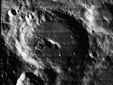
LOIV-070-H3
Images
LPOD Photo Gallery Lunar Orbiter Images Apollo Images
Maps
(LAC zone 127B3) LAC map Geologic map
Description
Description: Elger
(IAU Directions) VLACQ.--A member of a magnificent group of closely associated formations situated on the greatly disturbed area between E. long. 30 deg. and 45 deg. and S. lat. 50 deg. and 60 deg. It is 57 miles in diameter, and is enclosed by terraced walls, rising on the E. about 8,000 feet, and on the W. more than 10,000 feet above the floor. They are broken on the S. by a fine crater. In addition to a conspicuous central peak, there are several small craters, and low short ridges in the interior.
Description: Wikipedia
Additional Information
- Depth data from Kurt Fisher database
- Westfall, 2000: 3.83 km
- Viscardy, 1985: 3 km
- Cherrington, 1969: 1.18 km
- Central peak composition: A (Tompkins & Pieters, 1999)
- Vlacq and its satellite crater A are on the ALPO list of bright ray craters
Nomenclature
- Named for Adriaan Vlacq (1600-1667), a Dutch book publisher and mathematician. Vlacq published a table of Henry Briggs' logarithms from 1 to 100,000 to 10 decimal places in 1628 in his Arithmetica logarithmica.
- According to Whitaker (p. 214), this feature was labeled Pitiscus on Riccioli's map. The usage of the name Vlacq for the present feature was introduced by Mädler, although the same person had been honored earlier by Van Langren (with the spelling Vlacci and the name assigned to the feature now known as Capella) (Whitaker, pp. 219-220).
LPOD Articles
Bibliography
This page has been edited 1 times. The last modification was made by - tychocrater tychocrater on Jun 13, 2009 3:24 pm - afx3u2