Difference between revisions of "Rimae Sirsalis"
| Line 6: | Line 6: | ||
|} | |} | ||
<div id="toc"> | <div id="toc"> | ||
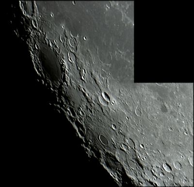
| − | + | [http://www.lpod.org/coppermine/displayimage.php?pid=113&fullsize=1 [[Image:normal_SirsalisRille.jpg|external image normal_SirsalisRille.jpg]]]<br /> ''[http://lpod.org/coppermine/displayimage.php?pos=-113 Tom Bash]'', [[Sirsalis|Sirsalis]], Sirsalis Rille (center), [[Grimaldi|Grimaldi]] (upper left). See this [http://www2.lpod.org/wiki/July_6,_2004 LPOD] for the identification of the features.<br /> <br /> | |
| − | |||
==Images== | ==Images== | ||
[http://www.lpod.org/coppermine/thumbnails.php?album=search&type=full&search=Rimae%20Sirsalis LPOD Photo Gallery] [http://www.lpi.usra.edu/resources/lunar_orbiter/bin/srch_nam.shtml?Rimae%20Sirsalis%7C0 Lunar Orbiter Images]<br /> <br /> | [http://www.lpod.org/coppermine/thumbnails.php?album=search&type=full&search=Rimae%20Sirsalis LPOD Photo Gallery] [http://www.lpi.usra.edu/resources/lunar_orbiter/bin/srch_nam.shtml?Rimae%20Sirsalis%7C0 Lunar Orbiter Images]<br /> <br /> | ||
| Line 37: | Line 36: | ||
Wood, C.A. 10/2005. The Straight Story on Linear Rilles. S&T 110(4):62-63<br /> Harold Hill. [[A%20Portfolio%20of%20Lunar%20Drawings|A Portfolio of Lunar Drawings]], pages 144, 145.<br /> <br /> <br /> | Wood, C.A. 10/2005. The Straight Story on Linear Rilles. S&T 110(4):62-63<br /> Harold Hill. [[A%20Portfolio%20of%20Lunar%20Drawings|A Portfolio of Lunar Drawings]], pages 144, 145.<br /> <br /> <br /> | ||
---- | ---- | ||
| − | + | </div> | |
Revision as of 16:46, 15 April 2018
Contents
Rimae Sirsalis
|
Lat: 15.7°S, Long: 61.7°W, Length: 426 km, Depth: km, Rükl: 50 |

Tom Bash, Sirsalis, Sirsalis Rille (center), Grimaldi (upper left). See this LPOD for the identification of the features.
Images
LPOD Photo Gallery Lunar Orbiter Images
Maps
(LAC zone 74D3) LAC map Geologic map
Description
Description: Elger
One of the longest clefts on the visible surface runs immediately E. of this formation Sirsalis. Commencing at a minute crater on the N. of it, it grazes the foot of the E. glacis; then, passing a pair of small overlapping craters (resembling Sirsalis and its companion in miniature), it runs through a very rugged country to a ring-plain W. of De Vico (De Vico a), which it traverses, and, still following a southerly course, extends towards Byrgius, in the neighbourhood of which it is apparently lost at a ridge, though Schmidt and Gaudibert have traced it still farther in the same direction. It is at least 300 miles in length, and varies much in width and character, consisting in places of distinct crater-rows.
Description: Wikipedia
Additional Information
- Magnetic field anomaly and nearby gravity anomaly. Milbury et al, 2008
- 1937 description and drawing by SRB Cooke.
Nomenclature
- Named from nearby crater. (Sirsalis)
- In the original IAU nomenclature of Blagg and Müller (1935) there were three Roman-numeralled rilles associated with Sirsalis (I, II, and III), and a separate feature known as the Sirsalis Cleft.
- This name (presumably the latter one) was Latinized to Rima Sirsalis in 1964 IAU Transactions XIIB.
- The deep southern end of the rille was known as Rima Byrgius (and, before that, the Byrgius Cleft).
- It is not entirely clear when these rille names were consolidated into the present Rimae Sirsalis.
LPOD Articles
The Longest Rille A Rille Draped Across the Landscape A Long Graben
Lunar 100
L77: Procellarum basin radial rilles.
Bibliography
Wood, C.A. 10/2005. The Straight Story on Linear Rilles. S&T 110(4):62-63
  Harold Hill. A Portfolio of Lunar Drawings, pages 144, 145.