Difference between revisions of "Grimaldi"
| Line 4: | Line 4: | ||
{| class="wiki_table" | {| class="wiki_table" | ||
| colspan="3" | | | colspan="3" | | ||
| − | Lat: 5.5°S, Long: 68.3°W, Main ring diam: 440 km, Depth: 3.2 km, [ | + | Lat: 5.5°S, Long: 68.3°W, Main ring diam: 440 km, Depth: 3.2 km, [[R%C3%BCkl%2039|Rükl: 39]]<br /> |
|- | |- | ||
| | | | ||
| Line 22: | Line 22: | ||
<br /> | <br /> | ||
==Maps== | ==Maps== | ||
| − | ''([ | + | ''([[LAC%20zone|LAC zone]] 74A4)'' [http://www.lpi.usra.edu/resources/mapcatalog/LAC/lac74/ LAC map] [http://www.lpi.usra.edu/resources/mapcatalog/usgs/I740/ Geologic map]<br /> <br /> |
| − | ==[ | + | ==[[Lunar%20Basins|Basin Classification]]== |
(Description of terms and most numeric basin data from Wood, C.A. (2004) [http://www.lpod.org/cwm/DataStuff/Lunar%20Basins.htm Impact Basin Database])<br /> | (Description of terms and most numeric basin data from Wood, C.A. (2004) [http://www.lpod.org/cwm/DataStuff/Lunar%20Basins.htm Impact Basin Database])<br /> | ||
{| class="wiki_table" | {| class="wiki_table" | ||
| Line 44: | Line 44: | ||
The feature originally named Grimaldi is the inner ring of a two ring structure now known as the Grimaldi Basin. The right image above shows the inner ring of the basin and the lava within it which could have been named Mare Grimaldi! The left image shows the inner ring and also, especially to the south (left) the outer basin rim and between the two rims a relatively smooth bright plains. <span class="membersnap">- [http://www.wikispaces.com/user/view/tychocrater [[Image:tychocrater-lg.jpg|16px|tychocrater]]] [http://www.wikispaces.com/user/view/tychocrater tychocrater] <small>Sep 4, 2007</small></span><br /> <br /> | The feature originally named Grimaldi is the inner ring of a two ring structure now known as the Grimaldi Basin. The right image above shows the inner ring of the basin and the lava within it which could have been named Mare Grimaldi! The left image shows the inner ring and also, especially to the south (left) the outer basin rim and between the two rims a relatively smooth bright plains. <span class="membersnap">- [http://www.wikispaces.com/user/view/tychocrater [[Image:tychocrater-lg.jpg|16px|tychocrater]]] [http://www.wikispaces.com/user/view/tychocrater tychocrater] <small>Sep 4, 2007</small></span><br /> <br /> | ||
==Description: Elger== | ==Description: Elger== | ||
| − | ''([ | + | ''([[IAU%20Directions|IAU Directions]])'' GRIMALDI.--This ranks among the largest wall-surrounded plains on the moon, and is perhaps the darkest. It extends 148 miles from N. to S. and 129 miles from W. to E., enclosing an area of some 14,000 square miles, or nearly double that of the principality of Wales. This vast dusky surface is bounded on the W. by a tolerably regular border, having an average height of about 4,000 feet, while on the opposite side it is much broken, and in places considerably loftier, rising at one peak on the S.E. to an altitude of 9,000 feet. About midway, also, this eastern rampart attains a great height, as may be seen by any one who observes at sunrise the magnificent shadow of it, and its many peaks thrown across the bluish-grey interior. On the S. the wall is broken by a large irregular depression, on the E. of which is a very curious V-shaped rill valley. On the N.E. it is comparatively low, and in places discontinuous; and even to a greater extent than on the S.E., intersected by passes. At the extreme N. end, a number of wide valleys cut through the wall and trend towards [[Lohrmann|Lohrmann]]. There is a considerable ring-plain at the inner foot of the N.W. wall, but, except this and a few longitudinal ridges, just visible under a very low sun, there is apparently no other object to vary the monotony of this great expanse.<br /> <br /> |
==Description: Wikipedia== | ==Description: Wikipedia== | ||
[http://en.wikipedia.org/wiki/Grimaldi_(crater) Grimaldi]<br /> <br /> | [http://en.wikipedia.org/wiki/Grimaldi_(crater) Grimaldi]<br /> <br /> | ||
==Additional Information== | ==Additional Information== | ||
| − | Depth data from [ | + | Depth data from [[Kurt%20Fisher%20crater%20depths|Kurt Fisher database]]<br /> |
* Cherrington, 1969: 3.2 km | * Cherrington, 1969: 3.2 km | ||
| Line 54: | Line 54: | ||
==Nomenclature== | ==Nomenclature== | ||
| − | * The IAU crater name honors [http://en.wikipedia.org/wiki/Francesco_Maria_Grimaldi Francesco Maria Grimaldi] (April 2, 1618 - December 28, 1663), an Italian mathematician and physicist. He built and used instruments to measure geological features on the Moon, and drew an accurate map or ''selenograph'' which was published by [ | + | * The IAU crater name honors [http://en.wikipedia.org/wiki/Francesco_Maria_Grimaldi Francesco Maria Grimaldi] (April 2, 1618 - December 28, 1663), an Italian mathematician and physicist. He built and used instruments to measure geological features on the Moon, and drew an accurate map or ''selenograph'' which was published by [[Riccioli|Riccioli]]. |
* The impact basin was named after the crater. | * The impact basin was named after the crater. | ||
* Grimaldi B, a small bright crater on the northern part of Grimaldi, was also known as '''Saheki''' (a name which was proposed by Hugh Percy Wilkins and Patrick Moore, see their book THE MOON), but the I.A.U. did not accept this name. | * Grimaldi B, a small bright crater on the northern part of Grimaldi, was also known as '''Saheki''' (a name which was proposed by Hugh Percy Wilkins and Patrick Moore, see their book THE MOON), but the I.A.U. did not accept this name. | ||
| Line 69: | Line 69: | ||
==Lunar 100== | ==Lunar 100== | ||
| − | * [ | + | * [[Lunar%20100|L36]]: A small two-ring basin. |
<br /> | <br /> | ||
==Bibliography== | ==Bibliography== | ||
Revision as of 14:50, 15 April 2018
Contents
Grimaldi Basin
(unofficial name; IAU crater name: Grimaldi; 172 km diam)
|
Lat: 5.5°S, Long: 68.3°W, Main ring diam: 440 km, Depth: 3.2 km, Rükl: 39 | ||
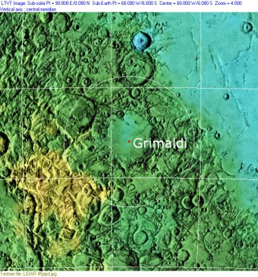
Middle: Clementine, Clementine LIDAR Altimeter texture from PDS Map-a-Planet remapped to north-up aerial view by LTVT. The dot is the center position and the white circle the main ring position from Chuck Wood's Impact Basin Database. Grid spacing = 10 degrees.
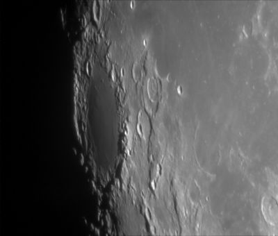
Right: LROC WAC image centred on 0 degrees longitude.
Table of Contents
Images
LPOD Photo Gallery Lunar Orbiter Images Apollo Images
- Trivia
- AS09-23-3500 is a curious NASA-photograph which shows the Last Quarter Moon, made by the crew of Apollo 9 (an Earth-orbiting mission to test the capabilities of the first Lunar Module in space)(LM Spider). The dark spot of Grimaldi is noticeable near the central part of the moon's limb. Research: Danny Caes
Maps
(LAC zone 74A4) LAC map Geologic map
Basin Classification
(Description of terms and most numeric basin data from Wood, C.A. (2004) Impact Basin Database)
| Certainty of Existence |
USGS Age |
Wilhelms Age Group |
Ring Diameters |
Mare Thickness |
Mascon |
| Certain |
Pre-Nectarian |
9 |
230, 300, 440 |
1.4 - 3.46 |
Yes |
Description
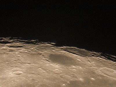
The feature originally named Grimaldi is the inner ring of a two ring structure now known as the Grimaldi Basin. The right image above shows the inner ring of the basin and the lava within it which could have been named Mare Grimaldi! The left image shows the inner ring and also, especially to the south (left) the outer basin rim and between the two rims a relatively smooth bright plains. - tychocrater tychocrater Sep 4, 2007
Description: Elger
(IAU Directions) GRIMALDI.--This ranks among the largest wall-surrounded plains on the moon, and is perhaps the darkest. It extends 148 miles from N. to S. and 129 miles from W. to E., enclosing an area of some 14,000 square miles, or nearly double that of the principality of Wales. This vast dusky surface is bounded on the W. by a tolerably regular border, having an average height of about 4,000 feet, while on the opposite side it is much broken, and in places considerably loftier, rising at one peak on the S.E. to an altitude of 9,000 feet. About midway, also, this eastern rampart attains a great height, as may be seen by any one who observes at sunrise the magnificent shadow of it, and its many peaks thrown across the bluish-grey interior. On the S. the wall is broken by a large irregular depression, on the E. of which is a very curious V-shaped rill valley. On the N.E. it is comparatively low, and in places discontinuous; and even to a greater extent than on the S.E., intersected by passes. At the extreme N. end, a number of wide valleys cut through the wall and trend towards Lohrmann. There is a considerable ring-plain at the inner foot of the N.W. wall, but, except this and a few longitudinal ridges, just visible under a very low sun, there is apparently no other object to vary the monotony of this great expanse.
Description: Wikipedia
Additional Information
Depth data from Kurt Fisher database
- Cherrington, 1969: 3.2 km
Nomenclature
- The IAU crater name honors Francesco Maria Grimaldi (April 2, 1618 - December 28, 1663), an Italian mathematician and physicist. He built and used instruments to measure geological features on the Moon, and drew an accurate map or selenograph which was published by Riccioli.
- The impact basin was named after the crater.
- Grimaldi B, a small bright crater on the northern part of Grimaldi, was also known as Saheki (a name which was proposed by Hugh Percy Wilkins and Patrick Moore, see their book THE MOON), but the I.A.U. did not accept this name.
- Saheki (the Japanese astronomer Tsuneo Saheki) discovered bright starlike spots on Mars, December 1951.
LPOD Articles
- Two Dead Mapmakers.
- Eclipse of Uranus.
- Professor and Student
- A Mystery Solved
- New View, Old Basin (Kaguya image)
Lunar 100
- L36: A small two-ring basin.
Bibliography
- A Portfolio of Lunar Drawings (Harold Hill), pages 140, 141, 142.
- Hawke, B.R. and others (2012) Localized Pyroclastic Deposits in the Grimaldi Region of the Moon. 43rd LPSC #1749.
This page has been edited 1 times. The last modification was made by - tychocrater tychocrater on Jun 13, 2009 3:24 pm - afx2


