Difference between revisions of "Eudoxus"
| (One intermediate revision by the same user not shown) | |||
| Line 5: | Line 5: | ||
Lat: 44.3°N, Long: 16.3°E, Diam: 67 km, Depth: 4.35 km, [http://the-moon.us/wiki/R%C3%BCkl%2013 Rükl: 13], [http://the-moon.us/wiki/Stratigraphy Copernican]<br /> | Lat: 44.3°N, Long: 16.3°E, Diam: 67 km, Depth: 4.35 km, [http://the-moon.us/wiki/R%C3%BCkl%2013 Rükl: 13], [http://the-moon.us/wiki/Stratigraphy Copernican]<br /> | ||
|} | |} | ||
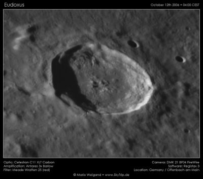
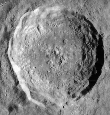
| − | [http://www.lpod.org/coppermine/displayimage.php?pid=1002&fullsize=1 [[Image: | + | [http://www.lpod.org/coppermine/displayimage.php?pid=1002&fullsize=1 [[Image:Normal_eudoxus2006-10-12a.jpg|external image normal_eudoxus2006-10-12a.jpg]]][http://www.lpod.org/coppermine/displayimage.php?pid=785&fullsize=1 [[Image:Normal_Eudoxus%204103_h2_raw.jpg|external image normal_Eudoxus%204103_h2_raw.jpg]]]<br /> Left: ''[http://lpod.org/coppermine/displayimage.php?pos=-1002 Mario Weigand]'', Oct 12, 2006, 0400 CEST, www.skytrip.de, Right:''[http://lpod.org/coppermine/displayimage.php?pos=-785 Lunar Orbiter IV-103-H2]''<br /> <br /> <div id="toc"> |
| − | + | ||
| − | |||
==Images== | ==Images== | ||
[http://www.lpod.org/coppermine/thumbnails.php?album=search&type=full&search=Eudoxus LPOD Photo Gallery] [http://www.lpi.usra.edu/resources/lunar_orbiter/bin/srch_nam.shtml?Eudoxus%7C0 Lunar Orbiter Images] [http://www.lpi.usra.edu/resources/apollo/search/feature/?feature=Eudoxus Apollo Images]<br /> <br /> | [http://www.lpod.org/coppermine/thumbnails.php?album=search&type=full&search=Eudoxus LPOD Photo Gallery] [http://www.lpi.usra.edu/resources/lunar_orbiter/bin/srch_nam.shtml?Eudoxus%7C0 Lunar Orbiter Images] [http://www.lpi.usra.edu/resources/apollo/search/feature/?feature=Eudoxus Apollo Images]<br /> <br /> | ||
| Line 15: | Line 14: | ||
<br /> | <br /> | ||
==Description: Elger== | ==Description: Elger== | ||
| − | ''([http://the-moon.us/wiki/IAU% | + | ''([http://the-moon.us/wiki/IAU%20directions IAU Directions])'' EUDOXUS.--A bright deep ring-plain, about 40 miles in diameter, in the hilly region between the [http://the-moon.us/wiki/Mare%20Serenitatis Mare Serenitatis] and the [http://the-moon.us/wiki/Mare%20Frigoris Mare Frigoris], with a border much broken by passes, and deviating considerably from circularity. Its massive walls, rising more than 11,000 feet above the floor on the E., and about 10,000 feet on the opposite side, are prominently terraced, and include crater-rows in the intervening valleys, while their outer slopes present a complicated system of spurs and buttresses. There is a bright crater on the N. <u>glacis</u>, and some distance beyond the wall on the N.E. is a small ring-plain, and on the S.W. another, with a conspicuous crater between it and the wall. Neison draws attention to an area of about 1,400 square miles on the N.W. which is covered with a great multitude of low hills. W. of Eudoxus are two short crossed clefts, and on the N. a long cleft of considerable delicacy running from N.W. to S.E. It was in connection with this formation that Trouvelot, on February 20, 1877, when the terminator passed through [http://the-moon.us/wiki/Aristillus Aristillus] and [http://the-moon.us/wiki/Alphonsus Alphonsus], saw a very narrow thread of light crossing the S. part of the interior and extending from border to border. He noted also similar appearances elsewhere, and termed them ''Murs enigmatiques''.<br /> <br /> |
==Description: Wikipedia== | ==Description: Wikipedia== | ||
[http://en.wikipedia.org/wiki/Eudoxus_%28crater%29 Eudoxus]<br /> <br /> | [http://en.wikipedia.org/wiki/Eudoxus_%28crater%29 Eudoxus]<br /> <br /> | ||
==Additional Information== | ==Additional Information== | ||
| − | * Depth data from [http://the-moon.us/wiki/Kurt%20Fisher% | + | * Depth data from [http://the-moon.us/wiki/Kurt%20Fisher%20Crater%20Depths Kurt Fisher database] |
** Westfall, 2000: 4.35 km | ** Westfall, 2000: 4.35 km | ||
** Viscardy, 1985: 3.35 km | ** Viscardy, 1985: 3.35 km | ||
| Line 41: | Line 40: | ||
'''Eudoxus A''' (Lamech's '''''Myriame'''''): Mapping and Naming the Moon; a history of lunar cartography and nomenclature (Ewen A. Whitaker).<br /> <br /> | '''Eudoxus A''' (Lamech's '''''Myriame'''''): Mapping and Naming the Moon; a history of lunar cartography and nomenclature (Ewen A. Whitaker).<br /> <br /> | ||
---- | ---- | ||
| − | + | </div> | |
Latest revision as of 01:48, 16 April 2018
Contents
Eudoxus
|
Lat: 44.3°N, Long: 16.3°E, Diam: 67 km, Depth: 4.35 km, Rükl: 13, Copernican |


Left: Mario Weigand, Oct 12, 2006, 0400 CEST, www.skytrip.de, Right:Lunar Orbiter IV-103-H2
Images
LPOD Photo Gallery Lunar Orbiter Images Apollo Images
Maps
(LAC zone 26A2) LAC map Geologic map
Description
Description: Elger
(IAU Directions) EUDOXUS.--A bright deep ring-plain, about 40 miles in diameter, in the hilly region between the Mare Serenitatis and the Mare Frigoris, with a border much broken by passes, and deviating considerably from circularity. Its massive walls, rising more than 11,000 feet above the floor on the E., and about 10,000 feet on the opposite side, are prominently terraced, and include crater-rows in the intervening valleys, while their outer slopes present a complicated system of spurs and buttresses. There is a bright crater on the N. glacis, and some distance beyond the wall on the N.E. is a small ring-plain, and on the S.W. another, with a conspicuous crater between it and the wall. Neison draws attention to an area of about 1,400 square miles on the N.W. which is covered with a great multitude of low hills. W. of Eudoxus are two short crossed clefts, and on the N. a long cleft of considerable delicacy running from N.W. to S.E. It was in connection with this formation that Trouvelot, on February 20, 1877, when the terminator passed through Aristillus and Alphonsus, saw a very narrow thread of light crossing the S. part of the interior and extending from border to border. He noted also similar appearances elsewhere, and termed them Murs enigmatiques.
Description: Wikipedia
Additional Information
- Depth data from Kurt Fisher database
- Westfall, 2000: 4.35 km
- Viscardy, 1985: 3.35 km
- Cherrington, 1969: 4.35 km
- Originally mapped as Copernican because has rays but these are compositional rays (highlands material) that have reached full optical maturity and thus Eudoxus is older than Copernicus and is Eratosthenian age. Hawke et al Composition and origin of Coprnican Rays… Mappers Conference 2005
- Central peak composition: A, GNTA & GNTA2 (Tompkins & Pieters, 1999)
- Eudoxus and its satellite crater A are on ALPO list of bright ray craters
- Satellite crater Eudoxus A is on the ALPO list of banded craters
- TSI = 35, CPI = 25, FI = 20; MI =80 Smith and Sanchez, 1973
Nomenclature
- Eudoxus of Cnidus (410 or 408 BC – 355 or 347 BC) was a Greek astronomer, mathematician, physician, scholar and student of Plato. Since all his own works are lost, our knowledge of him is obtained from secondary sources, such as Aratus's poem on astronomy.
- Eudoxus A, a secondary crater, was once known as Myriame (Soeur Myriame). This was one of Felix Lamech's new names, but the I.A.U. did not accept that name. Research: Ewen A. Whitaker and Danny Caes (august 2003, mail correspondence).
- The remains of a very ancient crater immediately east of Eudoxus (about the size of Eudoxus itself) is nicknamed Eudoxus's Ghost by Danny Caes. The discovery of this ancient crater (by Charles Wood) is described in the LPOD Before and way after.
- A previously undetected ridge which runs from the part of the Montes Caucasus near Eudoxus toward the southern rim of Lacus Mortis (over the couple Plana and Mason) to Williams is unofficially called Shannen Ridge by Maurice Collins (with Charles Wood co-author of the 21st Century Atlas of the Moon). The name Shannen Ridge is incorporated on chart 9 of this atlas.
LPOD Articles
A Table of Contents Almost Classic Crater Frigid Buddies: Aristoteles and Eudoxus Younger or Older Age Central peak More age Before and way after
Bibliography
Eudoxus A (Lamech's Myriame): Mapping and Naming the Moon; a history of lunar cartography and nomenclature (Ewen A. Whitaker).