Difference between revisions of "Montes Pyrenaeus"
| Line 7: | Line 7: | ||
|} | |} | ||
<div id="toc"> | <div id="toc"> | ||
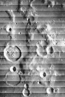
| − | [http://www.lpod.org/coppermine/displayimage.php?pid=1770&fullsize=1 [[Image: | + | [http://www.lpod.org/coppermine/displayimage.php?pid=1770&fullsize=1 [[Image:Normal_Montes_Pyrenaeus_LO_iv_065_h2.jpg|external image normal_Montes_Pyrenaeus_LO_iv_065_h2.jpg]]]<br /> ''[http://lpod.org/coppermine/displayimage.php?pos=-1770 LOIV 065 H2]''<br /> <br /> |
==Images== | ==Images== | ||
[http://www.lpod.org/coppermine/thumbnails.php?album=search&type=full&search=Montes%20Pyrenaeus LPOD Photo Gallery] [http://www.lpi.usra.edu/resources/lunar_orbiter/bin/srch_nam.shtml?Montes%20Pyrenaeus%7C0 Lunar Orbiter Images] [http://www.lpi.usra.edu/resources/apollo/search/feature/?feature=Montes%20Pyrenaeus Apollo Images]<br /> - The northern part of the '''Montes Pyrenaeus''' was photographed during the mission of Apollo 8. This frame ([http://history.nasa.gov/ap08fj/photos/13-e/med/as08-13-2227.jpg AS8-13-2227]) also shows the east-southeastern part of nearby '''Gutenberg''' (near the frame's lower margin).<br /> Research: Danny Caes<br /> HiRes scan of Apollo 8 photograph: David Woods and Frank O'Brien (''Apollo 8 Flight Journal'').<br /> <br /> | [http://www.lpod.org/coppermine/thumbnails.php?album=search&type=full&search=Montes%20Pyrenaeus LPOD Photo Gallery] [http://www.lpi.usra.edu/resources/lunar_orbiter/bin/srch_nam.shtml?Montes%20Pyrenaeus%7C0 Lunar Orbiter Images] [http://www.lpi.usra.edu/resources/apollo/search/feature/?feature=Montes%20Pyrenaeus Apollo Images]<br /> - The northern part of the '''Montes Pyrenaeus''' was photographed during the mission of Apollo 8. This frame ([http://history.nasa.gov/ap08fj/photos/13-e/med/as08-13-2227.jpg AS8-13-2227]) also shows the east-southeastern part of nearby '''Gutenberg''' (near the frame's lower margin).<br /> Research: Danny Caes<br /> HiRes scan of Apollo 8 photograph: David Woods and Frank O'Brien (''Apollo 8 Flight Journal'').<br /> <br /> | ||
| Line 15: | Line 15: | ||
<br /> | <br /> | ||
==Description: Elger== | ==Description: Elger== | ||
| − | ''([[IAU% | + | ''([[IAU%20directions|IAU Directions]])'' THE PYRENEES.--on the eastern side of the [[Mare%20Nectaris|Mare Nectaris]], extend in a meridional direction for nearly 190 miles, and include a peak west of [[Gutenberg|Guttemberg]] of nearly 12,000 feet, and are traversed in many places by fine valleys.<br /> <br /> |
==Description: Wikipedia== | ==Description: Wikipedia== | ||
[http://en.wikipedia.org/wiki/Montes_Pyrenaeus Montes Pyrenaeus]<br /> <br /> | [http://en.wikipedia.org/wiki/Montes_Pyrenaeus Montes Pyrenaeus]<br /> <br /> | ||
==Additional Information== | ==Additional Information== | ||
| − | Depth data from [[Kurt%20Fisher% | + | Depth data from [[Kurt%20Fisher%20Crater%20Depths|Kurt Fisher database]]<br /> |
* Viscardy, 1985: 3 km | * Viscardy, 1985: 3 km | ||
* Cherrington, 1969: 1.85 km | * Cherrington, 1969: 1.85 km | ||
Latest revision as of 02:06, 16 April 2018
Contents
Montes Pyrenaeus
(formerly Pyrenees (Mts.))
|
Lat: 15.6°S, Long: 41.2°E, Diam: 164 km, Height: 3 km, Rükl: 58 |
Images
LPOD Photo Gallery Lunar Orbiter Images Apollo Images
- The northern part of the Montes Pyrenaeus was photographed during the mission of Apollo 8. This frame (AS8-13-2227) also shows the east-southeastern part of nearby Gutenberg (near the frame's lower margin).
Research: Danny Caes
HiRes scan of Apollo 8 photograph: David Woods and Frank O'Brien (Apollo 8 Flight Journal).
Maps
(LAC zone 79C4) LAC map Geologic map
Description
Description: Elger
(IAU Directions) THE PYRENEES.--on the eastern side of the Mare Nectaris, extend in a meridional direction for nearly 190 miles, and include a peak west of Guttemberg of nearly 12,000 feet, and are traversed in many places by fine valleys.
Description: Wikipedia
Additional Information
Depth data from Kurt Fisher database
- Viscardy, 1985: 3 km
- Cherrington, 1969: 1.85 km
Nomenclature
- Named from terrestrial Pyrenees.
  - Maybe we could call the highest peak of the Montes Pyrenaeus the Aneto or Pico d'Aneto, because in the terrestrial Pyrenees the highest peak is also called the Aneto. - DannyCaes Nov 17, 2013
LROC Articles
Montes Pyrenaeus meets Mare Nectaris
Bibliography
