Difference between revisions of "Bailly"
(Created page with "<div id="content_view" class="wiki" style="display: block"> =Bailly Basin (with Wilkins's Hare on its floor)= ''(unofficial name; IAU crater name: '''Bailly'''; 287 km diam....") |
|||
| (4 intermediate revisions by the same user not shown) | |||
| Line 4: | Line 4: | ||
{| class="wiki_table" | {| class="wiki_table" | ||
| colspan="2" | | | colspan="2" | | ||
| − | Lat: 66.5°S, Long: 69.1°W, Main ring diam: 300 km, Depth: 4.13 km, [ | + | Lat: 66.5°S, Long: 69.1°W, Main ring diam: 300 km, Depth: 4.13 km, [[R%C3%BCkl%2071|Rükl: 71]]<br /> |
|- | |- | ||
| | | | ||
| − | [http://www.lpod.org/coppermine/displayimage.php?pid=1133&fullsize=1 [[Image: | + | [http://www.lpod.org/coppermine/displayimage.php?pid=1133&fullsize=1 [[Image:Normal_Bailly.jpg|external image normal_Bailly.jpg]]]<br /> |
| | | | ||
| − | [http://www.lpod.org/coppermine/displayimage.php?pid=2312&fullsize=1 [[Image: | + | [http://www.lpod.org/coppermine/displayimage.php?pid=2312&fullsize=1 [[Image:Normal_Bailly_Basin_LIDAR_LTVT.JPG|external image normal_Bailly_Basin_LIDAR_LTVT.JPG]]]<br /> |
|} | |} | ||
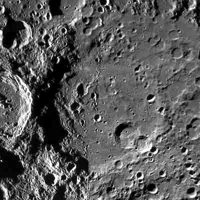
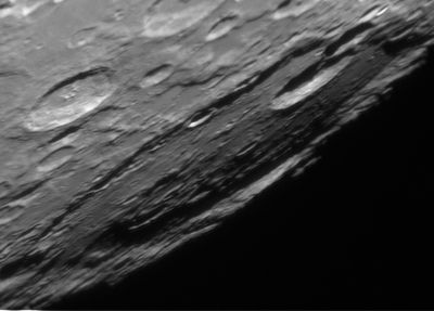
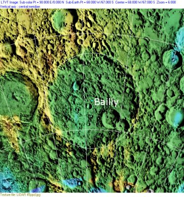
| − | '''Left:''' ''[http://lpod.org/coppermine/displayimage.php?pos=-1133 Elias Chasiotis]'', '''Right:''' ''[http://lpod.org/coppermine/displayimage.php?pos=-2312 Clementine]'', Clementine LIDAR Altimeter texture from [http://pdsmaps.wr.usgs.gov/PDS/public/explorer/html/lidrlvls.htm PDS Map-a-Planet] remapped to north-up aerial view by [http://www.henriksucla.dk/ LTVT]. The dot is the center position and the white circle the main ring position from Chuck Wood's [http://www.lpod.org/cwm/DataStuff/Lunar%20Basins.htm Impact Basin Database]. Grid spacing = 10 degrees.<br /> [http://the-moon. | + | '''Left:''' ''[http://lpod.org/coppermine/displayimage.php?pos=-1133 Elias Chasiotis]'', '''Right:''' ''[http://lpod.org/coppermine/displayimage.php?pos=-2312 Clementine]'', Clementine LIDAR Altimeter texture from [http://pdsmaps.wr.usgs.gov/PDS/public/explorer/html/lidrlvls.htm PDS Map-a-Planet] remapped to north-up aerial view by [http://www.henriksucla.dk/ LTVT]. The dot is the center position and the white circle the main ring position from Chuck Wood's [http://www.lpod.org/cwm/DataStuff/Lunar%20Basins.htm Impact Basin Database]. Grid spacing = 10 degrees.<br /> [http://the-moon.us/wiki/file/detail/bailly-large.jpg [[Image:Bailly-large.jpg|external image bailly-large.jpg|64x64px]]]<br /> '''Thumbnail:''' Clementine image from [http://www.mapaplanet.org/ Map-A-Planet] -- aerial viewed using [http://ltvt.wikispaces.com/LTVT LTVT] (click to enlarge).<br /> [[Image:Bailly.jpg|Bailly.jpg]] Left: Image from LRO WAC mosaic.<br /> <div id="toc"> |
| − | + | ||
| − | |||
==Images== | ==Images== | ||
[http://www.lpod.org/coppermine/thumbnails.php?album=search&type=full&search=Bailly LPOD Photo Gallery] [http://www.lpi.usra.edu/resources/lunar_orbiter/bin/srch_nam.shtml?Bailly%7C0 Lunar Orbiter Images]<br /> <br /> | [http://www.lpod.org/coppermine/thumbnails.php?album=search&type=full&search=Bailly LPOD Photo Gallery] [http://www.lpi.usra.edu/resources/lunar_orbiter/bin/srch_nam.shtml?Bailly%7C0 Lunar Orbiter Images]<br /> <br /> | ||
==Maps== | ==Maps== | ||
| − | ''([ | + | ''([[LAC%20zone|LAC zone]] 136A1)'' [http://planetarynames.wr.usgs.gov/images/Lunar/lac_136.pdf USGS Digital Atlas PDF]<br /> <br /> |
| − | ==[ | + | ==[[Lunar%20Basins|Basin Classification]]== |
(description of terms and most numeric basin data from Wood, C.A. (2004) [http://www.lpod.org/cwm/DataStuff/Lunar%20Basins.htm Impact Basin Database])<br /> | (description of terms and most numeric basin data from Wood, C.A. (2004) [http://www.lpod.org/cwm/DataStuff/Lunar%20Basins.htm Impact Basin Database])<br /> | ||
{| class="wiki_table" | {| class="wiki_table" | ||
| Line 39: | Line 38: | ||
<br /> | <br /> | ||
==Description: Elger== | ==Description: Elger== | ||
| − | ''([ | + | ''([[IAU%20directions|IAU Directions]])'' BAILLY.--One of the largest wall-surrounded plains on the moon, almost a "sea" in miniature, extending 150 miles from N. to S., and fully as much from E. to W. When caught at a favourable phase, it is, despite its position, especially worthy of scrutiny. The rampart on the E., of the linear type, is broken by several bright craters. On the S.E. two considerable overlapping ring-plains interfere with its continuity. On the S.W. several very remarkable parallel curved valleys traverse the border. The W. wall, which at one point attains a height of nearly 15,000 feet, is beautifully terraced. The floor on the western side includes several ring-plains (some of which are of a very abnormal type), many ridges, and two delicate dark lines, crossing each other near the S. end, probably representing clefts.<br /> <br /> |
==Description: Wikipedia== | ==Description: Wikipedia== | ||
[http://en.wikipedia.org/wiki/Bailly_(crater) Bailly]<br /> <br /> | [http://en.wikipedia.org/wiki/Bailly_(crater) Bailly]<br /> <br /> | ||
==Additional Information== | ==Additional Information== | ||
| − | * Depth data (for crater Baily) from [ | + | * Depth data (for crater Baily) from [[Kurt%20Fisher%20Crater%20Depths|Kurt Fisher database]] |
** Westfall, 2000: 4.13 km | ** Westfall, 2000: 4.13 km | ||
** Cherrington, 1969: 4.2 km | ** Cherrington, 1969: 4.2 km | ||
| Line 52: | Line 51: | ||
* The crater name honors [http://en.wikipedia.org/wiki/Jean_Sylvain_Bailly Jean-Sylvain Bailly] (September 15, 1736 – November 12, 1793), a French astronomer and orator, one of the leaders of the early part of the French Revolution. He had gained a high literary reputation and he devoted himself to writing about the history of science. | * The crater name honors [http://en.wikipedia.org/wiki/Jean_Sylvain_Bailly Jean-Sylvain Bailly] (September 15, 1736 – November 12, 1793), a French astronomer and orator, one of the leaders of the early part of the French Revolution. He had gained a high literary reputation and he devoted himself to writing about the history of science. | ||
* The impact basin is named after the crater. | * The impact basin is named after the crater. | ||
| − | * Crater '''Bailly B''', on the floor of '''Bailly''', was called [ | + | * Crater '''Bailly B''', on the floor of '''Bailly''', was called [[Unofficial%20Names%20of%20Hugh%20Percy%20Wilkins|Hare]] by Hugh Percy Wilkins and Patrick Moore, but the [[IAU|IAU]] did not accept that name. '''Hare''' was a contemporary American astronomer. |
| − | * A so-called mountain range in the neighborhood of '''Bailly''' was once known as [http://the-moon. | + | * A so-called mountain range in the neighborhood of '''Bailly''' was once known as [http://the-moon.us/wiki/Montes%20Doerfel Montes Doerfel] (see also H.Hill, bibliography). |
<br /> | <br /> | ||
==LPOD Articles== | ==LPOD Articles== | ||
| − | [http:// | + | [http://www2.lpod.org/wiki/November_24,_2006 A Little Basin.]<br /> [http://www2.lpod.org/wiki/December_1,_2006 Half a Loaf.]<br /> [http://www2.lpod.org/wiki/October_24,_2006 Southwest Taper.]<br /> [http://lpod.wikispaces.com/August%204%2C%202008 Especially Worthy of Scrutiny]<br /> [http://lpod.wikispaces.com/August%2011%2C%202008 Red & Blue on the Limb] (Anaglyph)<br /> <br /> |
==Lunar 100== | ==Lunar 100== | ||
| − | [ | + | [[Lunar%20100|L37]]: Barely discernible basin.<br /> <br /> |
==Bibliography== | ==Bibliography== | ||
| Line 64: | Line 63: | ||
* Wood. C.A. Sep. 2002. Bailly and Schiller. ''S&T'' Sept 2002 v104 p10 | * Wood. C.A. Sep. 2002. Bailly and Schiller. ''S&T'' Sept 2002 v104 p10 | ||
* Wood, C.A. April 2005. Basins of the Southwestern Limb. ''S&T'' 4/2005:70 | * Wood, C.A. April 2005. Basins of the Southwestern Limb. ''S&T'' 4/2005:70 | ||
| − | * Hill, Harold. 1991. [ | + | * Hill, Harold. 1991. [[Hill%2C%201991|A Portfolio of Lunar Drawings]]. '''Bailly''': Pages 128-129. '''Bailly and the Doerfels''': Pages 130-131. |
<br /> | <br /> | ||
---- | ---- | ||
| − | + | </div> | |
Latest revision as of 17:55, 22 April 2018
Contents
[hide]Bailly Basin (with Wilkins's Hare on its floor)
(unofficial name; IAU crater name: Bailly; 287 km diam.)
|
Lat: 66.5°S, Long: 69.1°W, Main ring diam: 300 km, Depth: 4.13 km, Rükl: 71 | |

Thumbnail: Clementine image from Map-A-Planet -- aerial viewed using LTVT (click to enlarge).
 Left: Image from LRO WAC mosaic.
Images
LPOD Photo Gallery Lunar Orbiter Images
Maps
(LAC zone 136A1) USGS Digital Atlas PDF
Basin Classification
(description of terms and most numeric basin data from Wood, C.A. (2004) Impact Basin Database)
| Certainty of Existence |
USGS Age |
Wilhelms Age Group |
Ring Diameters |
Mare Thickness |
Mascon |
| Probable |
Nectarian |
11 |
150, 300 km |
No |
Description
Description: Elger
(IAU Directions) BAILLY.--One of the largest wall-surrounded plains on the moon, almost a "sea" in miniature, extending 150 miles from N. to S., and fully as much from E. to W. When caught at a favourable phase, it is, despite its position, especially worthy of scrutiny. The rampart on the E., of the linear type, is broken by several bright craters. On the S.E. two considerable overlapping ring-plains interfere with its continuity. On the S.W. several very remarkable parallel curved valleys traverse the border. The W. wall, which at one point attains a height of nearly 15,000 feet, is beautifully terraced. The floor on the western side includes several ring-plains (some of which are of a very abnormal type), many ridges, and two delicate dark lines, crossing each other near the S. end, probably representing clefts.
Description: Wikipedia
Additional Information
- Depth data (for crater Baily) from Kurt Fisher database
- Westfall, 2000: 4.13 km
- Cherrington, 1969: 4.2 km
- First classified as basin by Hartmann & Wood (1971)
Nomenclature
- The crater name honors Jean-Sylvain Bailly (September 15, 1736 – November 12, 1793), a French astronomer and orator, one of the leaders of the early part of the French Revolution. He had gained a high literary reputation and he devoted himself to writing about the history of science.
- The impact basin is named after the crater.
- Crater Bailly B, on the floor of Bailly, was called Hare by Hugh Percy Wilkins and Patrick Moore, but the IAU did not accept that name. Hare was a contemporary American astronomer.
- A so-called mountain range in the neighborhood of Bailly was once known as Montes Doerfel (see also H.Hill, bibliography).
LPOD Articles
A Little Basin.
Half a Loaf.
Southwest Taper.
Especially Worthy of Scrutiny
Red & Blue on the Limb (Anaglyph)
Lunar 100
L37: Barely discernible basin.
Bibliography
- Elger, T. G. 1892. Selenographical notes. The Observatory, Vol. 15, p. 257-258. (extended description).
- Wood. C.A. Sep. 2002. Bailly and Schiller. S&T Sept 2002 v104 p10
- Wood, C.A. April 2005. Basins of the Southwestern Limb. S&T 4/2005:70
- Hill, Harold. 1991. A Portfolio of Lunar Drawings. Bailly: Pages 128-129. Bailly and the Doerfels: Pages 130-131.

