Difference between revisions of "Saunder"
| Line 6: | Line 6: | ||
|} | |} | ||
<div id="toc"> | <div id="toc"> | ||
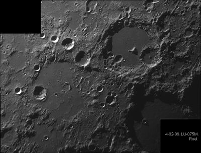
| − | + | [http://www.lpod.org/coppermine/displayimage.php?pid=209&fullsize=1 [[Image:normal_Mosaico-2.JPG|external image normal_Mosaico-2.JPG]]]<br /> ''[http://lpod.org/coppermine/displayimage.php?pos=-209 Eric Roel]'', [[Albategnius|Albategnius]], [[Hipparchus|Hipparchus]], [[Klein|Klein]], [[Halley|Halley]], [[Hind|Hind]], [[Horrocks|Horrocks]], '''Saunder''', [[Parrot|Parrot]] (with '''Saunder''' itself near the photograph's left margin, below the black rectangle)<br /> | |
| − | |||
=[[Image:Saunder.jpg|Saunder.jpg]]= | =[[Image:Saunder.jpg|Saunder.jpg]]= | ||
LRO<br /> <br /> <br /> | LRO<br /> <br /> <br /> | ||
| Line 26: | Line 25: | ||
==Ruins of a very ancient large crater southeast of Saunder== | ==Ruins of a very ancient large crater southeast of Saunder== | ||
| − | * Southeast of '''Saunder''' there seems to be a circle-shaped arrangement of elevations that looks more-or-less like the ruins of a large crater the size of '''Hipparchus'''. This circle-shaped tendency is depicted on [http://the-moon.us/wiki/SLC-C5 SLC map C5] (''System of Lunar Craters'', 1966). How much of this ancient crater could be observed during low-sun circumstances? <span class="membersnap">- | + | * Southeast of '''Saunder''' there seems to be a circle-shaped arrangement of elevations that looks more-or-less like the ruins of a large crater the size of '''Hipparchus'''. This circle-shaped tendency is depicted on [http://the-moon.us/wiki/SLC-C5 SLC map C5] (''System of Lunar Craters'', 1966). How much of this ancient crater could be observed during low-sun circumstances? <span class="membersnap">- DannyCaes <small>Jan 21, 2017</small></span> |
<br /> | <br /> | ||
==Nomenclature== | ==Nomenclature== | ||
| Line 38: | Line 37: | ||
<br /> <br /> | <br /> <br /> | ||
---- | ---- | ||
| − | + | </div> | |
Revision as of 16:50, 15 April 2018
Contents
Saunder
|
Lat: 4.2°S, Long: 8.8°E, Diam: 44 km, Depth: 0.64 km, Rükl: 45 |
Eric Roel, Albategnius, Hipparchus, Klein, Halley, Hind, Horrocks, Saunder, Parrot (with Saunder itself near the photograph's left margin, below the black rectangle)
LRO
Images
LPOD Photo Gallery Lunar Orbiter Images Apollo Images
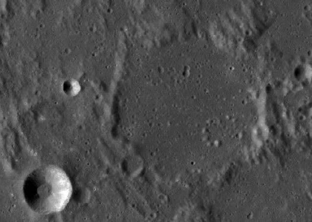
- Although the LPI's search list for orbital Apollo photographs shows nothing for Saunder, this crater WAS captured on several north-looking frames made by Apollo 16's mapping/metric Fairchild camera. One of those frames is AS16-M-0836, which shows Saunder a little bit above and to the right of the frame's centre.
- Research: Danny Caes.
Maps
(LAC zone 77B3) LAC map Geologic map LM map AIC map LTO map
Description
Description: Wikipedia
Additional Information
- Depth data from Kurt Fisher database
- Pike, 1976: 0.64 km
- Westfall, 2000: 0.64 km
- Satellite crater Saunder A is on the ALPO list of bright ray craters.
Ruins of a very ancient large crater southeast of Saunder
- Southeast of Saunder there seems to be a circle-shaped arrangement of elevations that looks more-or-less like the ruins of a large crater the size of Hipparchus. This circle-shaped tendency is depicted on SLC map C5 (System of Lunar Craters, 1966). How much of this ancient crater could be observed during low-sun circumstances? - DannyCaes Jan 21, 2017
Nomenclature
- Named for Samuel Arthur Saunder (1852-1912), a British mathematician and selenographer. In the early 1900's Saunder initiated a program to measure precise positions of lunar craters to extend the accuracy of hand drawn lunar maps. His control points served as the basis for the positions reported in the IAU's Named Lunar Formations. Saunder's Presidential Address to the 1903-4 Session of the BAA includes an interesting history of lunar cartography and its usefulness, or lack of usefulness, for detecting changes on the Moon.
- Named by Karl Müller in Named Lunar Formations in 1935 (Whitaker, p 229).
LPOD Articles
Bibliography

