Tortilla Flat
Contents
Tortilla Flat (Apollo 17 site formation name)
|
Lat: 20.2°N, Long: 30.7°E, Diam: 1 km, Depth: km, Rükl: 25 |

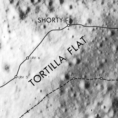
Apollo 17 Site Traverses Chart The dusting of bright material on the left is part of the landing site feature called Light Mantle. The lines indicate the paths followed by the astronauts on their lunar rover. The crater name Shorty is also an IAU-approved name.
Images
LPOD Photo Gallery Lunar Orbiter Images Apollo Images from air
Apollo images from ground: parts of Magazine C (137), Magazine I (138), and Magazine K (139).
Maps
(LAC zone 43D1) LAC map Geologic map LTO map Topophotomap Site Traverses chart.
Description
This is an IAU-approved name for a landing site feature at the Apollo 17 site in Taurus-Littrow Valley, crossed by the astronauts on EVA-2.
Description: Wikipedia
Additional Information
The Landing Site Name "Tortilla Flat" is plotted on Topophotomap 43D1/S1 and Site Traverses chart 43D1S2.
  For explanation and meaning of the name Tortilla Flat, or Tortilla Flats, see Nomenclature section below.
Nomenclature
Astronaut-named feature, Apollo 17 site.
- The citation in IAU Transactions XIVB somewhat vaguely defines this as a "flat region near the Light Mantle".
- Astronaut Harrison Schmitt recalled that "Tortilla Flats honors John Steinbeck and all writers who, in the 1930's and 40's, made us aware of the human side of the nation. With this legacy, today we attempt to equalize individual opportunity within the limits of human differences." (source: APOLLO LUNAR SURFACE JOURNAL, Eric M. Jones).
- Two craters south of the Tortilla Flat (near the southern part of the Lee-Lincoln Scarp) seem to have been called Candide and Nemo (source: APOLLO 17 Preliminary Science Report).- DannyCaes May 5, 2014
LPOD Articles
Bibliography