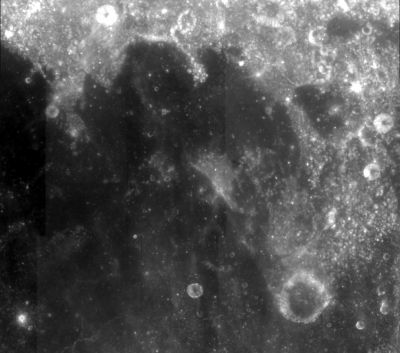
Sinus Successus
Contents
Sinus Successus - Luna 16 site
|
Lat: 0.9°N, Long: 59.0°E, Diam: 132 km, Depth: km, Rükl: 38 |
Images
Lunar Reconnaissance Orbiter image of Luna 16 descent stage.
 LPOD Photo Gallery Lunar Orbiter Images Apollo Images
  - Lunar Orbiter 1's frames 033 and 034 show Sinus Successus during local morning light.
  - AS15-88-11961 shows Apollo 15's CSM Endeavour over Sinus Successus. The bright crater in the upper right corner is Ameghino.
  - AS11-37-5443 shows Apollo 11's CSM Columbia over the central part of Sinus Successus. Compare the diagonal and somewhat curved high-albedo streak "below" the CSM with the one in the Clementine photograph above. Note: on the online version of this Hasselblad, north is to the right!
  Additional research Lunar Orbiter and Apollo photography: Danny Caes
Maps
(LAC zone 62D3) LAC map Geologic map LM map LTO map
Description
Description: Wikipedia
Additional Information
Lunar Orbiter 1's Frame 033 reveals two curious plateau-like elevations (mensae) in Sinus Successus. The large elevation is located at 1°10' North/ 55°25' East. The small one at 0°35' North/ 55°30' East.
  Research: Danny Caes
Nomenclature
- "Bay of Success".
- Landing site of Luna 16, the first successful robotic sample return from the Moon, following two months after Apollo 11, the first successful sample return from the Moon. - tychocrater Sep 2, 2007
LPOD Articles
Bibliography
