Rima Archytas
Contents
Rima Archytas
|
Lat: 53.0°N, Long: 3.0°E, Length: 90 km, Depth: km, Rükl: 4 |
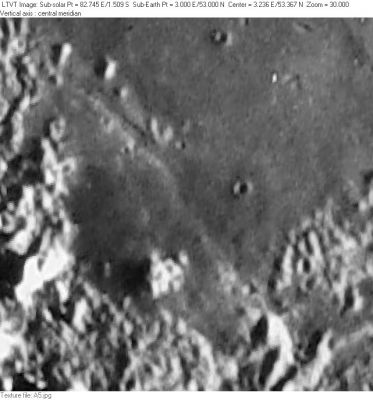
Consolidated Lunar Atlas -- Plate A5 This view is centered on a portion of Mare Frigoris north of Vallis Alpes and southwest of Protagoras. The graben-like channel of Rima Archytas can be seen passing between some low hills and unnamed craters in the upper left (at about 53.8°N/2.7°E). On still lower sun angle views it appears to extend south as a very shallow trough.
Images
LPOD Photo Gallery Lunar Orbiter Images Apollo Images
Maps
(LAC zone 12C2) LAC map Geologic map
Description
Description: Wikipedia
Additional Information
Nomenclature
- Named after nearby crater. (Archytas)
- Although a rille associated with Archytas (Archytas I) was included in the original 1935 IAU nomenclature of Blagg and Müller, Rima Archytas is among the many rille names listed in the IAU Planetary Gazetteer as having been approved in 1964. The System of Lunar Craters plotted Rima Archytas I as consisting of just the short channel visible in the Consolidated Lunar Atlas photo shown above (shown as about 6-km wide and 56 km long); however, as indicated in the figure caption, there is a shadowy extension of it to the south-southeast visible in still lower sun views. LAC-12 shows Rima Archytas I extending over this greater length, which seems to be a shallow trough. The on-line IAU Planetary Gazetteer seems to have adopted this latter definition, moving the center southward and giving Rima Archytas a “diameter” of 90 km (as quoted in the present title line). The best available Lunar Orbiter photos (taken at a sun angle of about 19°) reveal only a channel about 4 km wide and less than 20 km long near the center of the region plotted on the System of Lunar Craters charts. With the higher sun angle they are unable to confirm any extension of this channel to the north or south. - JimMosher
LPOD Articles
Bibliography
