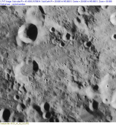
Montanari
Contents
Montanari
| Lat: 45.8°S, Long: 20.6°W, Diam: 76 km, Depth: 2.01 km, Rükl: 64 |
Images
LPOD Photo Gallery Lunar Orbiter Images
Maps
(LAC zone 111C4) LAC map Geologic map
Description
Description: Wikipedia
Additional Information
Depth data from Kurt Fisher database
- Westfall, 2000: 2.01 km
- Cherrington, 1969: 1.58 km
Nomenclature
- Geminiano Montanari (1633-1687); Italian astronomer and mathematician, trained as a lawyer. Perhaps best known in astronomy for his publication of the fact that the star Algol varied in brightness, he drew a careful map of the whole Moon which appeared in an Ephemeris of Cornelio Malvasia, published in 1662. The map attempted to combine observations for 12 successive nights culminating in the Full Moon of October 6, 1662.
- Name given by Fauth (Whitaker, p 227); incorporated in IAU's original Named Lunar Formations.
- Whitaker (pp. 73-4) dismisses Montanari's map as being "grotesque" and geometrically inaccurate; yet Montanari seems to have made measurements with an eyepiece reticle or micrometer of his own construction, carefully recording the Moon's changing diameter, with his results being published in the Malvasia Ephemeris. In a careful and exhaustive web-based study, Rodolfo Calanca has found that despite Whitaker's criticism Montanari's little-known map compares quite favorably to those that preceded it. - Jim Mosher
LPOD Articles
Bibliography
