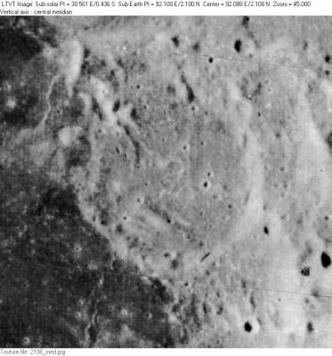
McAdie
Contents
McAdie
| Lat: 2.1°N, Long: 92.1°E, Diam: 45 km, Depth: km, Rükl: (farside) |
Images
LPOD Photo Gallery Lunar Orbiter Images
- Lunar Orbiter 1's frames 016, 017, 018, 019, and 020 show McAdie near the upper margins of all five frames. The depicted craters south of McAdie are Purkyne S (the LTO's Milton), Purkyne U (the LTO's Tasso), and Purkyne V (the LTO's Hugo).
- Research: Danny Caes
Maps
Description
Description: Wikipedia
Additional Information
Nomenclature
- Alexander George McAdie (August 8, 1863 - November 1, 1943) was an American meteorologist. In 1885 at Blue Hill, Boston, he modernized the experiments of Benjamin Franklin by attaching a voltmeter to a kite and measuring the voltage difference between the ground and several hundred feet up. He also made studies of the atmospheric effects of smoke, the connection between the aurora and electricity in the atmosphere, and the dangers posed by lightning.
- This name was introduced on LTO-64D4 (September, 1974) on which it was listed as "approved by the IAU" and for which it served as the chart title. The name was not actually formally approved until 1976 (IAU Transactions XVIB). It does not appear to replace any previous IAU-approved designation for this feature. - Jim Mosher
LPOD Articles
Bibliography
Alexander G. McAdie in the Sourcebook Project (William R. Corliss)
- In Lightning, Auroras, Nocturnal Lights, and related luminous phenomena (1982) :
- GLL10-R8: Phenomena Preceding Lightning (Alexander McAdie, Monthly Weather Review, 1928).
