Lade
Contents
Lade
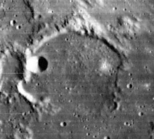
| Lat: 1.3°S, Long: 10.1°E, Diam: 55 km, Depth: 0.82 km, Rükl: 45 |
Images
LPOD Photo Gallery Lunar Orbiter Images Apollo Images
Maps
(LAC zone 78A1) LAC map Geologic map LM map AIC map
Description
Description: Wikipedia
Additional Information
Depth data from Kurt Fisher database
- Pike, 1976: 0.82 km
- Cherrington, 1969: 0.94 km
Curious clair-obscur effect at Lade
There's a monthly L.Q.-moon related clair-obscur effect at the bowl-shaped crater Lade M (on Lade's floor, near the northwestern part of the rim of Lade). During local sunset circumstances (evening terminator) a tiny bit of illumination is observable on the eastern inner slopes of Lade M (looks like a distinctive "star" which is lost in the shadow of the western part of Lade's rim). For those who are unfamiliar with this clair-obscur effect created by Lade M, take a look at the LPOD of December the 16th, 2014 (Lade and environs during local sunset, captured by Pavel Presnyakov, Kiev, Ukraine).
 - DannyCaes Dec 16, 2014
Nomenclature
Heinrich Eduard von Lade (February 24, 1817 – August 7, 1904) was a German banker and amateur astronomer. He built an observatory on his estate to pursue his interest in selenography, or mapping the Moon. He commissioned the construction of a lunar globe with one side in physical relief and the other with hashed relief and the crater names. This globe is now a very rare collector's item.
LPOD Articles
Bibliography
A Portfolio of Lunar Drawings (Harold Hill), pages 170, 171.
