Herodotus
Contents
[hide]Herodotus
|
Lat: 23.2°N, Long: 49.7°W, Diam: 34 km, Depth: 1.3 km, Rükl: 18 |


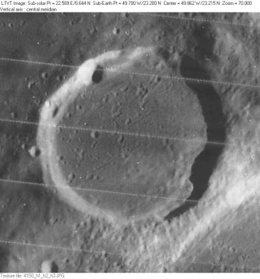
Left: LO-IV-150H Herodotus viewed from overhead. The 4-km crater on the northwest rim is Herodotus N.
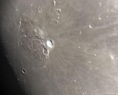
Right: Menno Jansen Herodotus, with the much brighter Aristarchus to its upper right, as seen from Earth. Schröter's Valley is nicely visible.
Images
LPOD Photo Gallery Lunar Orbiter Images Apollo Images
- Extreme closeup of Herodotus' southeast rim and floor: AS15-92-12493
Maps
(LAC zone 39D1) LAC map Geologic map LM map
Description
Description: Elger
(IAU Directions) HERODOTUS.--This far less brilliant but equally interesting object is about 23 miles in diameter, and is not so regular in shape as Aristarchus. Its E. wall rises at one point more than 4,000 feet above the very dusky floor. Except on the S.E. and N.W., the border is devoid of detail. On the S.E. three little notches may be detected on its summit, which probably represent small craters, while on the opposite side, on the inner slope, a little below the crest, is a large crater, easily seen. Both the W. and E. sections of the wall are prolonged towards the S. far beyond the limits of the formation. These rocky masses, with an intermediate wall, are very conspicuous under oblique illumination, that on the S.E. being especially brilliant. On the N. there is a gap through which the well-known serpentine cleft passes on to the floor. Between the N.E. side of Herodotus and Aristarchus is a large plateau, seen to the best advantage when the morning terminator lies a little distance W. of the former. It is traversed by a T-shaped cleft which communicates with the great serpentine cleft and extends towards the S. end of Aristarchus, till it meets a second cleft (forming the upper part of the T) running from the S.W. side of this formation along the E. side of Herodotus. The great serpentine cleft, discovered by Schroter, October 7, 1787, is in many respects the most interesting object of its class. ...(see Schröter's Valley)... The mountain plateau N. of Aristarchus deserves careful scrutiny, as it abounds in detail and includes many short clefts.
Description: Wikipedia
Additional Information
- Depth data from Kurt Fisher database
Pike, 1976: 1.3 km
Westfall, 2000: 1.3 km
Viscardy, 1985: 1.44 km
Cherrington, 1969: 1.43 km - Satellite craters Herodotus A, B and C are on the ALPO list of bright ray craters.
- A sketch of a peculiar observation by V.A.Firsoff (a "pseudo-peak" on the floor of Herodotus, 15th july 1955), was printed on page 182 of his book The Old Moon and the New, 1969.- DannyCaes May 19, 2012
Nomenclature
- Named for Herodotus of Halikarnassus (c. 484-408 B.C.); a Greek historian.
- According to Whitaker (p. 220), this name was introduced by Mädler, although he spelled it Herodot.
- Mary Blagg's Collated List (1913) indicates that both Neison and Schmidt used the modern spelling (Herodotus), which she adopted for Named Lunar Formations (1935).
- Herodotus Eta (the promontory at the southwestern end of Montes Agricola).
- Herodotus Lambda (hill at the western part of the Aristarchus plateau, aka the mustard colored Wood's spot).
- Herodotus Chi (nowadays known as Mons Herodotus, northwest of Herodotus itself, near the Montes Agricola).
- Herodotus Omega (the well-known dome south of Herodotus).
- Herodotus fault/ scarp (an unofficial name for the fault or scarp south of Herodotus) (it shows up as a black line during local morning illumination). - DannyCaes Dec 13, 2015
LPOD Articles
An Early Woman Observer of the Moon (Evelyn M. Whitehead) Equal Rims? Aperture
Bibliography