Gutenberg
Contents
Gutenberg
|
Lat: 8.6°S, Long: 41.2°E, Diam: 74 km, Depth: 1.75 km, Rükl 48 |
Images
LPOD Photo Gallery images Lunar Orbiter Images Apollo Images
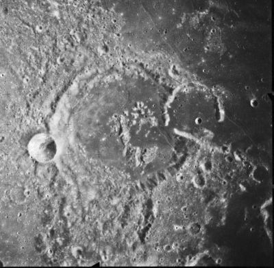
- A rather strange look at Gutenberg and the northwestern part of Goclenius is seen in an orbital photograph which was made during the mission of Luna 22 (looking southward, pre-sunset light).- DannyCaes Aug 8, 2010
Maps
(LAC zone 79C1) LAC map Geologic map
Description
Description: Elger
(IAU Directions) GUTTEMBERG.--A very fine ring-plain of peculiar shape, about 45 miles in width, with a lofty wall, broken on the N.E. by another ring-plain some 14 miles in diameter, and on the S.W. by a small but distinct crater. The border presents a wide opening towards the S., which is traversed by a number of longitudinal valleys, both the W. and E. sections of the wall being prolonged in this direction. A fine crater-row runs round the outer slope of the W. wall, from the crater just mentioned to the N. side of the formation. It is best seen when the E. wall is on the evening terminator. There is also a broad valley on the S. prolongation of the E. wall. The central mountain is bright but not large. A cleft crosses the N.E. side of the floor. North of Guttemberg there is a curious oblong formation with low walls, connected with the N.W. border by a ridge, and with the N. border by a remarkable row of depressions, situated on a mound; and beyond this object on the W. are three parallel clefts running towards the N.W. On the E. will be found some of the clefts belonging to the Goclenius rill-system. In the rugged region S.W. of the formation is a peculiar low ring with a very uneven floor and a large central hill. The W. wall of Guttemberg may be regarded as forming a portion of the The Pyrenees Mountains.
Description: Wikipedia
Additional Information
- Depth data from Kurt Fisher database
- Pike, 1976: 1.75 km
- Westfall, 2000: 1.75 km
- Viscardy, 1985: 2.28 km
- Cherrington, 1969: 2.28 km
- Central peak height:
- Sekiguchi, 1972: 1.0 km - fatastronomer
- Gutenberg C central peak height
- Sekiguchi, 1972: 1.2 km - fatastronomer
- Gutenberg G central peak height
- Sekiguchi, 1972: 1.1 km - fatastronomer
- Satellite crater Gutenberg A is on the ALPO list of bright ray craters.
- Satellite crater Gutenberg A is on the ALPO list of banded craters
Nomenclature
- Named for Johannes Gensfleisch zur Laden zum Gutenberg (c. 1400 – February 3, 1468), a German goldsmith and printer, who is credited with inventing movable type printing in Europe (ca. 1450) and mechanical printing globally. His major work, the Gutenberg Bible, also known as the 42-line bible, has been acclaimed for its high aesthetic and technical quality.
- This feature was Catalog number 4303 in Mary Blagg's Collated List, where the spelling is noted as Guttemberg or occasionally Gutemberg. It was introduced into the original IAU nomenclature of Named Lunar Formations as Gutenberg, with the name attributed to Beer and Mädler.
- Gutenberg G was called Vernet by Wilkins and Paluzie-Borrell, but the IAU did not accept that name. Joan Vernet Ginés was a contemporary Spanish astronomer.
- An officially unnamed formation near Gutenberg must receive the official name Mergenthaler, because Ottmar Mergenthaler was the inventor of the Linotype machine, which made him (Mergenthaler) the "second Gutenberg" in the rich history of book printing.- DannyCaes Mar 2, 2013
- Perhaps it might be interesting to know something about Beno Gutenberg (1889-1960, German-American seismologist). - DannyCaes May 12, 2015
LPOD Articles
Land of Milk, Honey and Rilles. Go See 'Em - They are Gut Rille Cut
Bibliography
- Hill, Harold . A Portfolio of Lunar Drawings, page 209 (the Goclenius rille system).
- Extensive web page about the crater and rille system.
