Fourier
Contents
Fourier
|
Lat: 30.3°S, Long: 53.0°W, Diam: 51 km, Depth: 2.98 km, Rükl: 61 |
Images
LPOD Photo Gallery Lunar Orbiter Images
Maps
(LAC zone 92C3) LAC map Geologic map
Description
Description: Elger
(IAU Directions) FOURIER.--A large ring-plain, 30 miles in diameter, S.E. of Vieta, with a border rising at a peak on the E. more than 9,000 feet above the floor, There are two craters on the outer slope of the N.E. wall, a prominent crater on the S. wall, and (according to Schmidt) a small central crater on the floor, which I have not seen. In the region between Fourier and Vieta there are three ring-plains, two (the more easterly) standing side by side, and on the E., towards the Mare, are two others much larger, that nearer to Fourier being traversed by one cleft, and the other by two clefts, crossing near the centre of the floor.
Description: Wikipedia
Additional Information
Depth data from Kurt Fisher database
- Westfall, 2000: 2.98 km
- Viscardy, 1985: 3.7 km
- Cherrington, 1969: 3.71 km
- Satellite crater Fourier E is on the ALPO list of banded craters.
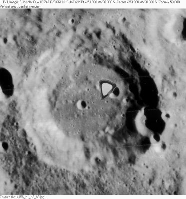
The illuminated cross near Fourier
- A curious clair-obscur effect, located at approximately 33° South/ 53° West (south of Fourier) is always observable when the morning-terminator runs at 46° or 47° West. The effect looks like some sort of illuminated "cross" or "airplane". - DannyCaes Dec 10, 2007
Nomenclature
- Jean Baptiste Joseph Fourier (March 21, 1768 - May 16, 1830) was a French mathematician and physicist who is best known for initiating the investigation of Fourier series and their application to problems of heat flow. The Fourier transform is also named in his honor. Fourier is also credited with the discovery in his essay in 1827 that gases in the atmosphere might increase the surface temperature of the Earth. This was the effect that would later be called the greenhouse effect. He established the concept of planetary energy balance - that planets obtain energy from a number of sources that cause temperature increase. Planets also lose energy by infrared radiation (that Fourier called "chaleur obscure" or "dark heat") with the rate increasing with temperature.
- Southwest of Fourier, immediately west of Fourier N (between Lacroix and Vieta) are the so-called Basaltic lava areas, thus nicknamed by Harold Hill (see H.Hill's book A PORTFOLIO OF LUNAR DRAWINGS, page 156-157). It is possible that Percy Wilkins and Paluzie-Borrell called these areas Comas Sola (the exact location of this name is uncertain).
- Comas Sola (Josep Comas Sola) was a Spanish astronomer (1868-1937).
- The name Comas Sola was not accepted by the I.A.U.
- The easy-to-observe system of the two connected dark spots which were nicknamed the Basaltic lava areas by Harold Hill, and possibly Comas Sola by Wilkins and Paluzie-Borrell, was also known as the Honey lake. This name (nickname) appeared on a moonmap which was included in the LPOD of February 11, 2004.
LPOD Articles
Bibliography
Comas Sola: THE MOON by H.P.Wilkins and P.Moore.
