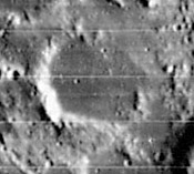
Dembowski
Contents
[hide]Dembowski
|
Lat: 2.9°N, Long: 7.2°E, Diam: 26 km, Depth: 0.28 km, Rükl: 34 |
Images
LPOD Photo Gallery Lunar Orbiter Images Apollo Images
- The LPI's searchlist for orbital Apollo photographs of Dembowski shows only one frame, but... there must be many more.- DannyCaes Aug 19, 2010
- Apollo 12's oblique north-looking Hasselblad AS12-52-7725 shows the almost invisible Dembowski near the frame's left margin, "above" the bright ray-craterlet.
- Although Dembowski itself is almost undetectable in Apollo 12's orbital color-photographs AS12-50-7402 and 7403, the table-mountain slightly southeast of Dembowski is a most distinct formation!
- Research Apollo photography: Danny Caes.
Maps
(LAC zone 59C3) LAC map Geologic map AIC map
Description
Description: Wikipedia
Additional Information
Depth data from Kurt Fisher database
- Westfall, 2000: 0.28 km
Nomenclature
- Named for Baron Ercole Dembowski (January 12, 1812 – January 19, 1881), an Italian astronomer. He was a tireless observer of double stars and made tens of thousands of micrometer measurements. In particular, he remeasured many double stars from Friedrich Struve's Dorpat Catalogue, noting how some of them had changed position over the years due to their mutual orbit as binary stars.
- The plateau at 2° North/ 8°20' East (southeast of Dembowski) was photographed in close-up by Lunar Orbiter 1 (Frame 1103 med). Rükl mentions this plateau on page 94 of his atlas (Map 34). Danny Caes calls the plateau "Dembowski Mensa" (the table-mountain near Dembowski). - DannyCaes Feb 23, 2008
LPOD Articles
Bibliography
