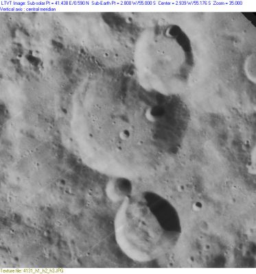
Deluc
Contents
[hide]Deluc
|
Lat: 55.0°S, Long: 2.8°W, Diam: 46 km, Depth: 5.21 km, Rükl: 73 |
Images
LPOD Photo Gallery Lunar Orbiter Images
Maps
(LAC zone 126B4) LAC map Geologic map
Description
Description: Elger
(IAU Directions) DELUC.--The largest and most prominent member of a curious group of ring- plains on the S.E. of Maginus. It is about 28 miles in diameter, and is encircled by a wall some 7,000 feet above the interior, which includes a crater. A large ring with a central mountain encroaches on the N. wall, and a smaller object of the same class on the S. wall.
Description: Wikipedia
Additional Information
- Depth data from Kurt Fisher database
- Westfall, 2000: 5.21 km
- Viscardy, 1985: 3.3 km
- The sun angle in LO-IV-131H is not low enough to make a definite determination of the crater depth. The encroaching crater on the north, mentioned by Elger (Deluc H) is 1,640 m deep, based on measurement of its shadow with LTVT. The one below Deluc (Deluc D) is 2,900 m deep. - Jim Mosher
- When the morning terminator runs at 1° to 2° West, there's a remarkable "illuminated number 2" visible on the eastern parts of Deluc and nearby crater Deluc D. Crater Deluc forms the upper part of the "2" (the bowl of the "2"), and crater Deluc D forms the lower part of it (the horizontal bar, which is curved downward, looking a bit "nonchalant"). Discovered by Danny Caes (may the 12th, 2008).
Nomenclature
- Jean-André Deluc (February 8, 1727 - November 7, 1817) was a Swiss geologist and physicist. His favorite studies were geology and meteorology. The situation of his native country had naturally led him to contemplate the peculiarities of the earths structure, and the properties of the atmosphere, as particularly displayed in mountainous countries, and as subservient to the measurement of heights. According to Georges Cuvier, he ranked among the first geologists of his age.
- Southeast of Deluc (between Deluc and Zach) is a crater which was once called Pollock. The name "Pollock" was printed on the moonmap which is online as LPOD February 11, 2004.
- Southwest of Deluc (between Deluc, Clavius, and Cysatus) is a region which was once called Terra Photographica. This name was also printed on the same moonmap (LPOD February 11, 2004).
- This nomenclature ("Pollock" and "Terra Photographica") was once proposed by William Radcliff Birt, but the I.A.U. did not accept both names.
LPOD Articles
Bibliography
- Birt's "Pollock" and "Terra Photographica": MAPPING AND NAMING THE MOON, Ewen A. Whitaker (page 221, Appendix J).
