Cleostratus
Contents
Cleostratus
|
Lat: 60.4°N, Long: 77.0°W, Diam: 62 km, Depth: 4.04 km, Rükl 1, pre-Nectarian |
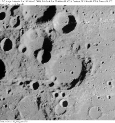
LO-IV-190M Among the many lettered craters visible in this view are 21-km Cleostratus E, on the rim at about 10 o'clock; 50-km Cleostratus F beyond that; and 35-km Cleostratus A (at top center). Directly above Cleostratus F, 56-km Boole A is cut in half by the top margin. In the lower left corner of the frame, the northwest floor of 125-km Xenophanes is dimly visible.
Images
LPOD Photo Gallery Lunar Orbiter Images
Maps
(LAC zone 10A1) USGS Digital Atlas PDF
Description
Description: Elger
(IAU Directions) CLEOSTRATUS.--A small ring-plain, N. of Xenophanes, surrounded by a number of similar objects, all too near the limb for observation.
Description: Wikipedia
Additional Information
Depth data from Kurt Fisher database
- Westfall, 2000: 4.04 km
- Viscardy, 1985: 2.4 km
- Cherrington, 1969: 2.19 km
Nomenclature
Cleostratus (ca. 520 BC; possibly 548 BC to 432 BC) was an astronomer of ancient Greece. He is believed by some scholars to have introduced the zodiac (beginning with Aries and Sagittarius) and the solar calendar to Greece from Babylonia.
The valley west-southwest of Cleostratus is unofficially called Vallis Cleostratus by D.Caes.
LPOD Articles
Bibliography
