Spurr
Contents
Spurr (in Palus Putredinis)
(formerly [/Archimedes Archimedes] M)
|
Lat: 27.89°N, Long: 1.28°W, Diam: 13.21 km, Depth: 0.1 km, [/R%C3%BCkl%2022 Rükl: 22] |
Table of Contents
[#Spurr (in Palus Putredinis) Spurr (in Palus Putredinis)]
[#Spurr (in Palus Putredinis)-Images Images]
[#Spurr (in Palus Putredinis)-Maps Maps]
[#Spurr (in Palus Putredinis)-Description Description]
[#Spurr (in Palus Putredinis)-Description-Wikipedia Wikipedia]
[#Spurr (in Palus Putredinis)-Additional Information Additional Information]
[#Spurr (in Palus Putredinis)-Nomenclature Nomenclature]
[#Spurr (in Palus Putredinis)-LPOD Articles LPOD Articles]
[#Spurr (in Palus Putredinis)-Bibliography Bibliography]

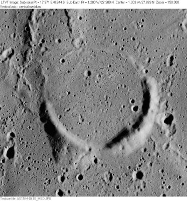
AS15-M-0418 Spurr, a "ruined" crater in the northwestern part of [/Palus%20Putredinis Palus Putredinis], near [/Archimedes Archimedes], is marked by a surviving crescent of unflooded crater rim. The ridges in the upper left are not named.
Images
LPOD Photo Gallery Lunar Orbiter Images Apollo Images
- Spurr was also captured by the panoramic ITEK camera of Apollo 15. AS15-P-9823 shows the arc of the shadowless Spurr beyond (to the right) of the frame's centre.
- Research orbital Apollo 15 photography: Danny Caes
Maps
([/LAC%20zone LAC zone] 41A3) LAC map Geologic map LM map LTO map
Description
Wikipedia
Additional Information
- IAU page: Spurr
- Depth data from [/Kurt%20Fisher%20crater%20depths Kurt Fisher database]
- Westfall, 2000: 0.1 km
- From the shadows in AS15-M-0418, the east wall rises to from 130-155 m above the central mare, increasing to about 180 m at one point in the southwest. On the west, the highest point (casting the longest shadow) is about 245 m above the mare. These values appear to be consistent with the 100-m contours (obtained by stereo mapping) on LTO 41A3. - JimMosher JimMosher
Nomenclature
- Named for Josiah Edward Spurr (1870-1950), an American geologist who wrote a multi-volume book about the Moon, called Geology Applied to Selenology.
- This replacement name for a formerly [/lettered%20crater lettered crater] was introduced on LTO-41A3 (Jan. 1974; for which it served as the chart title). Spurr appears in the cumulative list of approved names in [/IAU%20Transactions%20XVB IAU Transactions XVB] (1973), and does not appear in any of the previous Transactions, so the name appears to have been approved in that year. Biographical information was unofficially reported in [/Ashbrook%2C%201974 Ashbrook, 1974].- JimMosher JimMosher
- Although the LTO identifies the former name as [/Archimedes Archimedes] K it in fact appars to have been [/Archimedes Archimedes] M (as reported in Ashbrook).
- Not to be confused with Spur (craterlet near the site of Apollo 15), or Silver Spur (mountain near the site of Apollo 15).
LPOD Articles
Bibliography
- J. E. Spurr. Geology Applied to Selenology:
- I. The Imbrian Plain Region of the Moon (Lancaster, Pennsylvania: Science Press Publishing Co., 1944), 112 pages.
- II. The Features of the Moon (Lancaster, Pennsylvania: Science Press Publishing Co., 1945), 318 pages;
- III. Lunar Catastrophic History (Concord, New Hampshire: Rumford Press., 1948), 253 pages;
- IV. The Shrunken Moon (Concord, New Hampshire: Rumford Press., 1949), 207 pages.
[/Alphabetical%20Index Named Featues] -- Prev: [/Spur Spur] -- Next: [/St.%20George St. George]
This page has been edited 1 times. The last modification was made by - tychocrater tychocrater on Jun 13, 2009 3:24 pm - afx3u3