Difference between revisions of "Sharp"
(Created page with "<div id="content_view" class="wiki" style="display: block"> =Sharp= {| class="wiki_table" | Lat: 45.7°N, Long: 40.2°W, Diam: 39 km, Depth: 3.84 km, [/R%C3%BCkl%2010 Rük...") |
|||
| Line 37: | Line 37: | ||
<br /> | <br /> | ||
==LPOD Articles== | ==LPOD Articles== | ||
| − | [http:// | + | [http://www2.lpod.org/wiki/May_18,_2005 A Sharper Image]<br /> <br /> |
==Bibliography== | ==Bibliography== | ||
A curiosity...<br /> This is not at all related to '''Abraham Sharp''' and/or the nearside crater officially known as '''Sharp''', but... perhaps it's quite interesting to know ''':'''<br /> A certain '''Robert P. Sharp''' is mentioned on page 395 of ''Mysterious Universe, a handbook of astronomical anomalies'' (William R. Corliss, ''The Sourcebook Project'', 1979), as co-author of the article '''Channels on Mars''' (together with Michael C. Malin, ''Bulletin of the Geological Society of America'', 1975). <span class="membersnap">- [http://www.wikispaces.com/user/view/DannyCaes [[Image:DannyCaes-lg.jpg|16px|DannyCaes]]] [http://www.wikispaces.com/user/view/DannyCaes DannyCaes] <small>Apr 19, 2015</small></span><br /> | A curiosity...<br /> This is not at all related to '''Abraham Sharp''' and/or the nearside crater officially known as '''Sharp''', but... perhaps it's quite interesting to know ''':'''<br /> A certain '''Robert P. Sharp''' is mentioned on page 395 of ''Mysterious Universe, a handbook of astronomical anomalies'' (William R. Corliss, ''The Sourcebook Project'', 1979), as co-author of the article '''Channels on Mars''' (together with Michael C. Malin, ''Bulletin of the Geological Society of America'', 1975). <span class="membersnap">- [http://www.wikispaces.com/user/view/DannyCaes [[Image:DannyCaes-lg.jpg|16px|DannyCaes]]] [http://www.wikispaces.com/user/view/DannyCaes DannyCaes] <small>Apr 19, 2015</small></span><br /> | ||
---- | ---- | ||
This page has been edited 1 times. The last modification was made by <span class="membersnap">- [http://www.wikispaces.com/user/view/tychocrater [[Image:tychocrater-lg.jpg|16px|tychocrater]]] [http://www.wikispaces.com/user/view/tychocrater tychocrater]</span> on Jun 13, 2009 3:24 pm - ''afx3u2''</div> | This page has been edited 1 times. The last modification was made by <span class="membersnap">- [http://www.wikispaces.com/user/view/tychocrater [[Image:tychocrater-lg.jpg|16px|tychocrater]]] [http://www.wikispaces.com/user/view/tychocrater tychocrater]</span> on Jun 13, 2009 3:24 pm - ''afx3u2''</div> | ||
Revision as of 20:31, 11 April 2018
Contents
Sharp
|
Lat: 45.7°N, Long: 40.2°W, Diam: 39 km, Depth: 3.84 km, [/R%C3%BCkl%2010 Rükl: 10], [/Stratigraphy Upper Imbrian] |
Table of Contents
[#Sharp Sharp]
[#Sharp-Images Images]
[#Sharp-Maps Maps]
[#Sharp-Description Description]
[#Sharp-Description: Elger Description: Elger]
[#Sharp-Description: Wikipedia Description: Wikipedia]
[#Sharp-Additional Information Additional Information]
[#Sharp-Nomenclature Nomenclature]
[#Sharp-LPOD Articles LPOD Articles]
[#Sharp-Bibliography Bibliography]

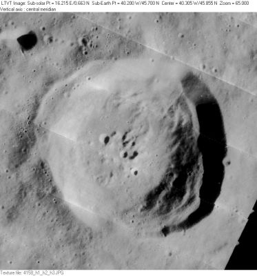
LO-IV-158H
Images
LPOD Photo Gallery Lunar Orbiter Images Apollo Images
Maps
([/LAC%20zone LAC zone] 23B2) LAC map Geologic map
Description
Description: Elger
([/IAU%20Directions IAU Directions]) SHARP.--A ring-plain somewhat smaller than [/Mairan Mairan], on the W. of the [/Sinus%20Iridum Sinus Iridum], from the coast-line of which it is separated by lofty mountains. There is a distinct crater at the foot of its N.W. wall, and a bright central mountain on the floor. On the N. is a prominent enclosure, nearly as large as Sharp itself; and on the N.W. a brilliant little ring- plain, A, about 8 miles in diameter, connected with Sharp, as Madler shows, by a wide valley.
Description: Wikipedia
Additional Information
- Depth data from [/Kurt%20Fisher%20crater%20depths Kurt Fisher database]
- Westfall, 2000: 3.84 km
- Viscardy, 1985: 3.2 km
- From the shadows in LO-IV-158H, the terrace along the upper east rim of Sharp is 1700-2700 m tall. Obviously, the crater as a whole is deeper than that. - JimMosher JimMosher
- Sharp B
- Satellite crater Sharp B is on the [/ALPO%20list%20of%20bright%20ray%20craters ALPO list of bright ray craters].
- Central ridge heights
- [/Sekiguchi%2C%201972 Sekiguchi, 1972]: 0.3 km - fatastronomer fatastronomer
- TSI = 30, CPI = 20, FI = 20; MI =70 [/Smith%20and%20Sanchez%2C%201973 Smith and Sanchez, 1973]
Nomenclature
- Named for Abraham Sharp (1651-1742), a British astronomer and mathematician.
- According to [/Whitaker Whitaker] (p. 218), this name was introduced (in the form Sharpius) by [/Schr%C3%B6ter Schröter]. As Whitaker notes, Schröter was using a name he had found on a list prepared by [/Hell Hell], and apparently used by Hell for the same feature (p. 93).
- Crater Sharp B was called Aymat by Hugh Percy Wilkins and Paluzie-Borrel (see the book [/Wilkins%20and%20Moore The Moon] by H.P.Wilkins and P.Moore), but the I.A.U. did not accept that name. Aymat (Antonio Aymat Mareca) was a Spanish astronomer.
- Sharp Xi (hill southwest of Foucault Beta, altogether with the nearby hill Foucault Gamma sometimes called Montes Foucault). See Chart 7 in the Times Atlas of the Moon.
LPOD Articles
Bibliography
A curiosity...
  This is not at all related to Abraham Sharp and/or the nearside crater officially known as Sharp, but... perhaps it's quite interesting to know :
  A certain Robert P. Sharp is mentioned on page 395 of Mysterious Universe, a handbook of astronomical anomalies (William R. Corliss, The Sourcebook Project, 1979), as co-author of the article Channels on Mars (together with Michael C. Malin, Bulletin of the Geological Society of America, 1975). - DannyCaes DannyCaes Apr 19, 2015
This page has been edited 1 times. The last modification was made by - tychocrater tychocrater on Jun 13, 2009 3:24 pm - afx3u2