Schlüter
Contents
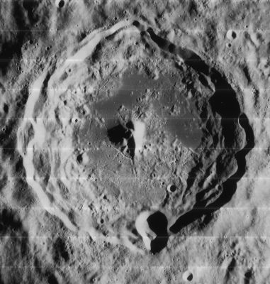
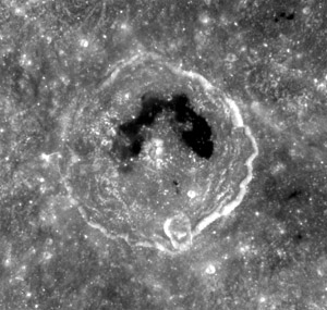
Schlüter (with Mare Hiemis on its floor)
|
Lat: 5.9°S, Long: 83.3°W, Diam: 89 km, Depth: 2.98 km, Rükl: 39, Upper Imbrian |


Left: Lunar Orbiter IV 181-h3, Right: Clementine
Table of Contents
[#Schlüter (with Mare Hiemis on its floor) Schlüter (with Mare Hiemis on its floor)]
[#Schlüter (with Mare Hiemis on its floor)-Images Images]
[#Schlüter (with Mare Hiemis on its floor)-Maps Maps]
[#Schlüter (with Mare Hiemis on its floor)-Description Description]
[#Schlüter (with Mare Hiemis on its floor)-Description: Wikipedia Description: Wikipedia]
[#Schlüter (with Mare Hiemis on its floor)-Additional Information Additional Information]
[#Schlüter (with Mare Hiemis on its floor)-Nomenclature Nomenclature]
[#Schlüter (with Mare Hiemis on its floor)-LPOD Articles LPOD Articles]
[#Schlüter (with Mare Hiemis on its floor)-Bibliography Bibliography]
Images
LPOD Photo Gallery Lunar Orbiter Images Apollo Images
Maps
(LAC zone 73A3) USGS Digital Atlas PDF
Description
Description: Wikipedia
Additional Information
- Depth data from Kurt Fisher database
- Westfall, 2000: 2.98 km
- Crater depth: 2980 m (Westfall, 2000); >3100 m (LTVT: LO-IV-181-H3)
- Central peak height: ~2250 m (LTVT: LO-IV-181-H3)
- During the mission of Apollo 17 in december 1972, crater Schluter and its environs were photographed in earthlight, when the lunar sunrise-terminator was still too eastward. During the whole time of Apollo 17's exploration, the direct sunlight never reached Schluter. These earthlight photographs are included in Apollo 17's Magazine 161-ZZ (35mm NIKON B&W photographs), see: Sheet 8 of A17's Index Maps. Some of those photographs were reproduced in the Apollo 17 Preliminary Science Report. - DannyCaes DannyCaes Dec 22, 2007
- TSI = 35, CPI = 20, FI = 25; MI =80 Smith and Sanchez, 1973
- According to Wikipedia, Lunar Orbiter 5 impacted north of Schluter (2.79° South/ 83.1° West).
- There seems to be a Skylight in or near crater Schluter, an exploration of the Lunar Reconnaissance Orbiter's (LRO's) NAC photographs is needed.
Nomenclature
- Heinrich; German astronomer (1815-1844).
- This crater was named Malvasia by Schröter (Cornelio Malvasia, Marquis di Bismantova), Riccioli b by Beer and Mädler, Riccioli A in Named Lunar Formations, Lowe by H.P.Wilkins, and finally it received it's modern name from D.W.G. Arthur in the Rectified Lunar Atlas. Lowe was an American astronomer.
- The name Mare Hiemis, given by Franz to the small dark patch on the floor of Schlüter, was eliminated in the RLC. [from Baum & Whitaker (2007) Discovery and nomenclature of the Mare Orientale. J Br. Astron. Assoc. 117, 3, p 129-135.]
- It is possible that Schluter P was called Buss by Wilkins and Moore, but the I.A.U. did not accept that name. Buss was an English spectroscopist.
- Rimae Schluter (an unofficial name from somebody who want to see much more names for systems of rilles on the floors of lunar craters, such as the system of rilles on the floor of Schluter).
LPOD Articles
Eclipse of Uranus. Two in a Row The Edge of a Bull's Eye Morphology An Overlooked Gem (part of Schluter A)
Bibliography
"Buss", "Lowe": THE MOON by H.P.Wilkins and P.Moore.
  "Malvasia", "Mare Hiemis": MAPPING AND NAMING THE MOON by E.A.Whitaker.
This page has been edited 1 times. The last modification was made by - tychocrater tychocrater on Jun 13, 2009 3:24 pm - afx4