Rimae Vasco da Gama
Contents
Rimae Vasco da Gama
|
Lat: 10.0°N, Long: 82.0°W, Length: 60 km, Depth: km, Rükl: 28 |
Table of Contents
[#Rimae Vasco da Gama Rimae Vasco da Gama]
[#Rimae Vasco da Gama-Images Images]
[#Rimae Vasco da Gama-Maps Maps]
[#Rimae Vasco da Gama-Description Description]
[#Rimae Vasco da Gama-Description: Wikipedia Description: Wikipedia]
[#Rimae Vasco da Gama-Additional Information Additional Information]
[#Rimae Vasco da Gama-Nomenclature Nomenclature]
[#Rimae Vasco da Gama-LPOD Articles LPOD Articles]
[#Rimae Vasco da Gama-Bibliography Bibliography]

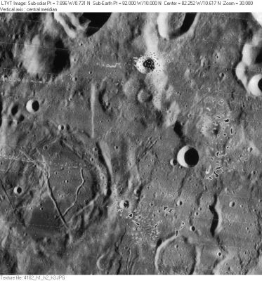
LO-IV-182H The IAU feature name appears to apply to the rille system running from the 59-km diameter Vasco da Gama R on the lower left to the 91-km diameter Vasco da Gama P, partially visible in the upper right.
Images
LPOD Photo Gallery Lunar Orbiter Images Apollo Images
Maps
(LAC zone 55A3) USGS Digital Atlas PDF
Description
Description: Wikipedia
Additional Information
Nomenclature
Named from nearby crater. (Vasco da Gama)
LPOD Articles
Bibliography
This page has been edited 1 times. The last modification was made by - tychocrater tychocrater on Jun 13, 2009 3:24 pm - afx3u2