Difference between revisions of "Rimae Archimedes"
(Created page with "<div id="content_view" class="wiki" style="display: block"> =Rimae Archimedes= {| class="wiki_table" | Lat: 26.6°N, Long: 4.1°W, Length: 169 km, Depth: km, [/R%C3%BCkl%2...") |
|||
| Line 10: | Line 10: | ||
==Images== | ==Images== | ||
[http://www.lpod.org/coppermine/thumbnails.php?album=search&type=full&search=Rimae%20Archimedes LPOD Photo Gallery] [http://www.lpi.usra.edu/resources/lunar_orbiter/bin/srch_nam.shtml?Rimae%20Archimedes%7C0 Lunar Orbiter Images] [http://www.lpi.usra.edu/resources/apollo/search/feature/?feature=Rimae%20Archimedes Apollo Images]<br /> | [http://www.lpod.org/coppermine/thumbnails.php?album=search&type=full&search=Rimae%20Archimedes LPOD Photo Gallery] [http://www.lpi.usra.edu/resources/lunar_orbiter/bin/srch_nam.shtml?Rimae%20Archimedes%7C0 Lunar Orbiter Images] [http://www.lpi.usra.edu/resources/apollo/search/feature/?feature=Rimae%20Archimedes Apollo Images]<br /> | ||
| − | * An [http://the-moon. | + | * An [http://the-moon.us/wiki/file/detail/Rimae-Archimedes-IV-109-H3.jpg interpretation] of '''Rimae Archimedes''' by [http://www.wikispaces.com/user/view/JohnMoore2 John Moore] based on Lunar Orbiter photo [http://www.lpi.usra.edu/resources/lunar_orbiter/images/img/iv_109_h3.jpg IV-109-H3] and the notations in the [/Lunar%20Orbiter%20Photographic%20Atlas%20of%20the%20Near%20Side%20of%20the%20Moon book] by Charles Byrne. This image shows a small region to the southeast of [/Archimedes Archimedes]. As indicated on the [http://www.lpi.usra.edu/resources/mapcatalog/LAC/lac41/ LAC] map, '''Rimae Archimedes''' was traditionally a system of six numbered [/rima rilles], mostly in or around the [/Montes%20Archimedes Montes Archimedes] region. The upper row of red dots in the right hand image have been placed above a part of the traditional '''Rima Archimedes IV''', while the lower dots suggest the location of a previously unnumbered branch. |
<br /> | <br /> | ||
==Maps== | ==Maps== | ||
Revision as of 20:28, 11 April 2018
Contents
Rimae Archimedes
|
Lat: 26.6°N, Long: 4.1°W, Length: 169 km, Depth: km, [/R%C3%BCkl%2022 Rükl: 22] |
Table of Contents
[#Rimae Archimedes Rimae Archimedes]
[#Rimae Archimedes-Images Images]
[#Rimae Archimedes-Maps Maps]
[#Rimae Archimedes-Description Description]
[#Rimae Archimedes-Description: Wikipedia Description: Wikipedia]
[#Rimae Archimedes-Additional Information Additional Information]
[#Rimae Archimedes-Nomenclature Nomenclature]
[#Rimae Archimedes-LPOD Articles LPOD Articles]
[#Rimae Archimedes-Bibliography Bibliography]

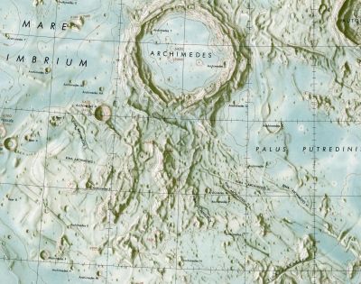
LAC-41 This detail of an [/LAC LAC] map from 1963 identifies six Roman-numeralled [/rima rilles] that were then associated with [/Archimedes Archimedes]. The entire complex is now known as Rimae Archimedes.
Images
LPOD Photo Gallery Lunar Orbiter Images Apollo Images
- An interpretation of Rimae Archimedes by John Moore based on Lunar Orbiter photo IV-109-H3 and the notations in the [/Lunar%20Orbiter%20Photographic%20Atlas%20of%20the%20Near%20Side%20of%20the%20Moon book] by Charles Byrne. This image shows a small region to the southeast of [/Archimedes Archimedes]. As indicated on the LAC map, Rimae Archimedes was traditionally a system of six numbered [/rima rilles], mostly in or around the [/Montes%20Archimedes Montes Archimedes] region. The upper row of red dots in the right hand image have been placed above a part of the traditional Rima Archimedes IV, while the lower dots suggest the location of a previously unnumbered branch.
Maps
([/LAC%20zone LAC zone] 41A3) LAC map Geologic map LM map LTO map
Description
Description: Wikipedia
Additional Information
Nomenclature
- Named from nearby crater ([/Archimedes Archimedes]).
- Catalog entries 1173-1184 in Mary Blagg's [/Collated%20List Collated List] of 1913 are devoted to rilles associated with [/Archimedes Archimedes], all of which were mapped by Neison, and a lesser number by Schmidt.
- Based on the listing provided by the Army Map Service, the original IAU nomenclature of [/Blagg%20and%20M%C3%BCller Blagg and Müller] seems to have retained six of these. Their locations are plotted on the accompanying maps.
- The [/System%20of%20Lunar%20Craters System of Lunar Craters] also has six rilles named after [/Archimedes Archimedes], but as indicated on [/Quad%20Maps Quad Map] D3, they seem to have been completely renamed from the designations used by [/Blagg%20and%20M%C3%BCller Blagg and Müller]. In particular, the former Archimedes I, III and IV have become [/Rima%20Bradley Rima Bradley], with the Latinized designation Rima Archimedes I moving to a feature previously unrecognized by the [/IAU IAU].
- The designations on the [/LAC LAC] map reproduced above appear to be the same as those proposed in the [/System%20of%20Lunar%20Craters System of Lunar Craters].
- [/NASA%20SP-241 NASA SP-241] (not an official IAU publication), attempts to identify the IAU-named features on [/Lunar%20Orbiter Lunar Orbiter] photos. It lists five of the Archimedes rilles in its index (omitting #1), and makes the following identifications of the remainder with [/Collated%20List Collated List] numbers: II=1175, III=1178, IV=1179, V=1180, VI=1182. With the exception of the omission of Rima Archimedes I, the numbering and identification in [/NASA%20SP-241 SP-241] appears to be the same as that in the [/LAC LAC] map reproduced above.
- In 1973 the IAU expressed its intention of renaming multiple [/rima rille systems], and since then the status of the Roman-numeraled desginations has been unclear, with the former systems currently being referred to in their entirety as "rimae".
- The current nomenclature maps in the IAU-approved [/USGS%20Digital%20Atlas USGS Digital Atlas] label five rilles as part of Rimae Archimedes. These appear to include Rima Archimedes I of the [/System%20of%20Lunar%20Craters System of Lunar Craters], but seem to omit its Rima Archimedes IV (possibly because labeling it would have created too much clutter?).
LPOD Articles
Bibliography
This page has been edited 1 times. The last modification was made by - tychocrater tychocrater on Jun 13, 2009 3:24 pm - afx3u2