Rima Burckhardt
Contents
Rima Burckhardt
(discontinued? [/IAU IAU] name)
| Lat: 32.7°N, Long: 59.3°E, Diam: 107 km, Depth: , Rükl: 16 |
Table of Contents
[#Rima Burckhardt Rima Burckhardt]
[#Rima Burckhardt-Images Images]
[#Rima Burckhardt-Maps Maps]
[#Rima Burckhardt-Description Description]
[#Rima Burckhardt-Description: Elger Description: Elger]
[#Rima Burckhardt-Description: Wikipedia Description: Wikipedia]
[#Rima Burckhardt-Additional Information Additional Information]
[#Rima Burckhardt-Nomenclature Nomenclature]
[#Rima Burckhardt-LPOD Articles LPOD Articles]
[#Rima Burckhardt-Bibliography Bibliography]

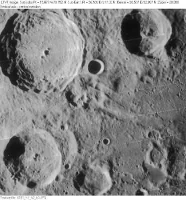
LO-IV-191H The large crater in the upper left is [/Geminus Geminus]. To its right is [/Bernoulli Bernoulli], and in the lower left is [/Burckhardt Burckhardt]. Rima Burckhardt I, one of three rilles associated with [/Burckhardt Burckhardt] in the original [/IAU%20Nomenclature IAU Nomenclature] runs across the frame from the unnamed crater on the southeast edge of [/Geminus Geminus] to just north of the unnamed crater with the raised edge near the right margin. To the north of Rima Burckhardt I, there is a transition from smooth low terrain to a rougher highland (most obvious just south of Bernoulli). This is regarded as on the "Geminus ring" of the [/Mare%20Crisium Crisium Basin], which is to the south.
Images
LPOD Photo Gallery Lunar Orbiter Images
Maps
([/LAC%20zone LAC zone] 28D) USGS Digital Atlas PDF (not labeled); also partially seen, but not labeled, on LAC-44
- Rima Burckhardt I was mapped by [/Neison%2C%201876 Neison] and by [/System%20of%20Lunar%20Craters Arthur et al.] (neither of whom seems to have gotten the angle quite right):
(click to see larger versions of these zero-libration north-up views from the LPOD Notes pages for June 23, 2008) - Rima Burckhardt I is also prominent on [/R%C3%BCkl Rükl]'s map.
Description
As described by Elger, the former(?) Rima Burckhardt I appears to consist of two parallel graben-type rilles. As shown in the Lunar Orbiter IV-191H, the rilles are near one of the rings of the [/Mare%20Crisium Crisium Basin], but not concentric with it.
Description: Elger
([/IAU%20Directions IAU Directions]) GEMINUS.-- ... Two fine clefts are easily visible within the ring, one running for some distance on the S.W. side of the floor, mounting the inner slope of the S.E. border to the summit ridge (where it is apparently interrupted), and then striking across the plain in a S.E. direction. Here it is accompanied for a short distance by a somewhat coarser companion, running parallel to it on the N.
Description: Wikipedia
Additional Information
Nomenclature
- Named after the nearby crater ([/Burckhardt Burckhardt]).
- The original IAU nomenclature of [/Blagg%20and%20M%C3%BCller Blagg and Müller] (1935) included three Roman-numeraled rilles associated with [/Burckhardt Burckhardt]. The present feature was Rima Burckhardt I, and is described as running from [/Geminus Geminus] to [/Geminus Geminus] Gamma (a now obsolete name for one of the ring of elevations to the east of [/Burckhardt Burckhardt]). It was apparently first described by [/Neison%2C%201876 Neison]. Rima Burckhardt II and III (names attributed to [/Schmidt Schmidt]) seem to have referred to the "ears" of [/Burckhardt Burckhardt], now known as [/Burckhardt Burckhardt] E and F.
- In the [/System%20of%20Lunar%20Craters System of Lunar Craters], Rima Burckhardt II and III were replaced by the [/lettered%20crater lettered crater] names, but Rima Burckhardt I was retained and labeled on [/Quad%20Maps Quad Map] A2. It was not labeled on the LAC maps, although the chart on which its center would have been depicted (LAC-28) was never completed.
- Rima Burckhardt I is plotted and labeled on four different pages of NASA [/NASA%20SP-241 SP-241], each time in a different way. Only on p. 387 ("177-2.3") is it drawn as described in [/Named%20Lunar%20Formations Named Lunar Formations] and [/Neison%2C%201876 Neison]. On pp. 43, 58 and 411 it is shown curving to the south, ending a little to the west or east of [/Burckhardt Burckhardt] C (the small, deeply shadowed, circular crater to the east of [/Burckhardt Burckhardt]).
- The name does not appear in the original [/IAU%20Planetary%20Gazetteer IAU Planetary Gazetteer] on which the current on-line version is based. Whether this was an intentional omission, or not, is unknown. The name is also not listed in NASA's parallel effort [/NASA%20RP-1097 RP-1097] (a non-IAU publication). But there does not appear to be any record of the name having been formally dropped.
LPOD Articles
visible in: A Single Twin [/LPOD%20June%2023%2C%202008 An Older Tycho]
Bibliography
This page has been edited 1 times. The last modification was made by - tychocrater tychocrater on Jun 13, 2009 3:24 pm - afx4

