Difference between revisions of "Ramsden"
(Created page with "<div id="content_view" class="wiki" style="display: block"> =Ramsden= {| class="wiki_table" | Lat: 32.9°S, Long: 31.8°W, Diam: 25.1 km, Depth: 1.9 km, [/R%C3%BCkl%2063 R...") |
|||
| Line 3: | Line 3: | ||
{| class="wiki_table" | {| class="wiki_table" | ||
| | | | ||
| − | Lat: 32.9°S, Long: 31.8°W, Diam: 25.1 km, Depth: 1.9 km, [ | + | Lat: 32.9°S, Long: 31.8°W, Diam: 25.1 km, Depth: 1.9 km, [[R%C3%BCkl%2063|Rükl: 63]]<br /> |
|} | |} | ||
<div id="toc"> | <div id="toc"> | ||
| Line 12: | Line 12: | ||
[http://www.lpod.org/coppermine/thumbnails.php?album=search&type=full&search=Ramsden LPOD Photo Gallery] [http://www.lpi.usra.edu/resources/lunar_orbiter/bin/srch_nam.shtml?Ramsden%7C0 Lunar Orbiter Images] [http://www.lpi.usra.edu/resources/apollo/search/feature/?feature=Ramsden Apollo Images]<br /> <br /> | [http://www.lpod.org/coppermine/thumbnails.php?album=search&type=full&search=Ramsden LPOD Photo Gallery] [http://www.lpi.usra.edu/resources/lunar_orbiter/bin/srch_nam.shtml?Ramsden%7C0 Lunar Orbiter Images] [http://www.lpi.usra.edu/resources/apollo/search/feature/?feature=Ramsden Apollo Images]<br /> <br /> | ||
==Maps== | ==Maps== | ||
| − | ''([ | + | ''([[LAC%20zone|LAC zone]] 111A2)'' [http://www.lpi.usra.edu/resources/mapcatalog/LAC/lac111/ LAC map] [http://www.lpi.usra.edu/resources/mapcatalog/usgs/I824/ Geologic map]<br /> <br /> |
==Description== | ==Description== | ||
<br /> | <br /> | ||
==Description: Elger== | ==Description: Elger== | ||
| − | ''([ | + | ''([[IAU%20Directions|IAU Directions]])'' RAMSDEN.--This ring-plain, 12 miles in diameter, derives its importance from the remarkable rill-system with which it is so closely associated. Its border, about 1,800 feet on the E. above the outside surface, is slightly terraced within on the W., where there is an unrecorded bright crater on the slope. The two principal clefts on the S. originate among the hills W. of [[Capuanus|Capuanus]]. The more westerly begins at a crater on the N. edge of these objects, and runs N. to the W. side of Ramsden; the other originates at a larger crater, and proceeds in a N. direction up to a bright little mountain S.E. of Ramsden; when, swerving to the N.W., it ends at the E. wall of this formation. This mountain is a centre or node from which three other more delicate branches radiate. On the N., three of the shortest clefts pertaining to the system are easily traceable from neighbouring mountains up to the N. wall, which they apparently partially cut through. The W. pair have a common origin, but open out as they approach the border of Ramsden.<br /> <br /> |
==Description: Wikipedia== | ==Description: Wikipedia== | ||
[http://en.wikipedia.org/wiki/Ramsden_(crater) Ramsden]<br /> <br /> | [http://en.wikipedia.org/wiki/Ramsden_(crater) Ramsden]<br /> <br /> | ||
==Additional Information== | ==Additional Information== | ||
| − | * Depth data from [ | + | * Depth data from [[Kurt%20Fisher%20crater%20depths|Kurt Fisher database]] |
** Pike, 1976: 1.9 km | ** Pike, 1976: 1.9 km | ||
** Arthur, 1974: 1.99 km | ** Arthur, 1974: 1.99 km | ||
| Line 37: | Line 37: | ||
==Bibliography== | ==Bibliography== | ||
| − | * Harold Hill. ''[ | + | * Harold Hill. ''[[A%20Portfolio%20of%20Lunar%20Drawings|A Portfolio of Lunar Drawings]]'', pages 154, 155 (the western portion of [[Palus%20Epidemiarum|Palus Epidemiarum]]). |
<br /> | <br /> | ||
---- | ---- | ||
This page has been edited 1 times. The last modification was made by <span class="membersnap">- [http://www.wikispaces.com/user/view/tychocrater [[Image:tychocrater-lg.jpg|16px|tychocrater]]] [http://www.wikispaces.com/user/view/tychocrater tychocrater]</span> on Jun 13, 2009 3:24 pm - ''afx3u2''</div> | This page has been edited 1 times. The last modification was made by <span class="membersnap">- [http://www.wikispaces.com/user/view/tychocrater [[Image:tychocrater-lg.jpg|16px|tychocrater]]] [http://www.wikispaces.com/user/view/tychocrater tychocrater]</span> on Jun 13, 2009 3:24 pm - ''afx3u2''</div> | ||
Revision as of 16:09, 15 April 2018
Contents
Ramsden
|
Lat: 32.9°S, Long: 31.8°W, Diam: 25.1 km, Depth: 1.9 km, Rükl: 63 |
Table of Contents

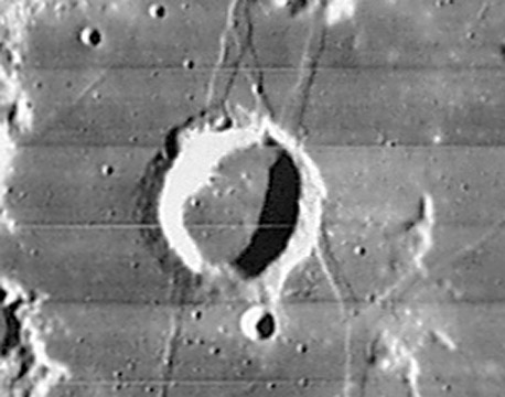
LO IV-136-h3

Ramsden - LRO
Images
LPOD Photo Gallery Lunar Orbiter Images Apollo Images
Maps
(LAC zone 111A2) LAC map Geologic map
Description
Description: Elger
(IAU Directions) RAMSDEN.--This ring-plain, 12 miles in diameter, derives its importance from the remarkable rill-system with which it is so closely associated. Its border, about 1,800 feet on the E. above the outside surface, is slightly terraced within on the W., where there is an unrecorded bright crater on the slope. The two principal clefts on the S. originate among the hills W. of Capuanus. The more westerly begins at a crater on the N. edge of these objects, and runs N. to the W. side of Ramsden; the other originates at a larger crater, and proceeds in a N. direction up to a bright little mountain S.E. of Ramsden; when, swerving to the N.W., it ends at the E. wall of this formation. This mountain is a centre or node from which three other more delicate branches radiate. On the N., three of the shortest clefts pertaining to the system are easily traceable from neighbouring mountains up to the N. wall, which they apparently partially cut through. The W. pair have a common origin, but open out as they approach the border of Ramsden.
Description: Wikipedia
Additional Information
- Depth data from Kurt Fisher database
- Pike, 1976: 1.9 km
- Arthur, 1974: 1.99 km
- Westfall, 2000: 1.9 km
- Viscardy, 1985: 2 km
- Cherrington, 1969: 1.79 km
- The system of three rilles just north of Ramsden (which are almost typographically "N"-shaped), is an interesting target for telescope operators at public observatories! - DannyCaes DannyCaes Aug 4, 2009
- Certain digital lunar atlases show totally wrong coordinates for Ramsden (or just "no" coordinates)(0° 00' N / 0° 00' E). The same phenomenon is noticeable at craterlet Priscilla. - DannyCaes DannyCaes Feb 15, 2010
Nomenclature
- Named for Jesse Ramsden (October 6, 1735 - November 5, 1800), an English astronomical and scientific instrument maker. Ramsden's speciality was divided circles, which began to supersede the quadrants in observatories towards the end of the 18th century. Ramsden is also responsible for the achromatic eyepiece named after him.
LPOD Articles
How He Does It (the Ramsden/ Marth sector, by Leo Aerts).
Bibliography
- Harold Hill. A Portfolio of Lunar Drawings, pages 154, 155 (the western portion of Palus Epidemiarum).
This page has been edited 1 times. The last modification was made by - tychocrater tychocrater on Jun 13, 2009 3:24 pm - afx3u2