Difference between revisions of "O'Day"
(Created page with "<div id="content_view" class="wiki" style="display: block"> =O'Day= {| class="wiki_table" | Lat: 30.62°S, Long: 157.5°E, Diam: 72.66 km, Depth: 5.6 km, Rükl: ''(farside...") |
|||
| Line 3: | Line 3: | ||
{| class="wiki_table" | {| class="wiki_table" | ||
| | | | ||
| − | Lat: 30.62°S, Long: 157.5°E, Diam: 72.66 km, Depth: 5.6 km, Rükl: ''(farside)'', [http://the-moon. | + | Lat: 30.62°S, Long: 157.5°E, Diam: 72.66 km, Depth: 5.6 km, Rükl: ''(farside)'', [http://the-moon.us/wiki/Stratigraphy Copernican]<br /> |
|} | |} | ||
<div id="toc"> | <div id="toc"> | ||
| Line 11: | Line 11: | ||
[http://www.lpod.org/coppermine/thumbnails.php?album=search&type=full&search=O%27Day LPOD Photo Gallery] [http://www.lpi.usra.edu/resources/lunar_orbiter/bin/srch_nam.shtml?O%27Day%7C0 Lunar Orbiter Images] [http://www.lpi.usra.edu/resources/apollo/search/feature/?feature=O%27Day Apollo Images]<br /> [http://www.lpi.usra.edu/resources/lunarorbiter/images/preview/2075_h3.jpg LO-II 075 h3] is a HiRes scan of Lunar Orbiter II's detailed photograph of '''O'Day''' (upper part of photograph, south up), with a curious elongated depression near the photograph's lower left corner (called '''Barbier K''')(according to LAC 103 in the ''Clementine Atlas of the Moon'').<br /> Additional research: Danny Caes<br /> <br /> | [http://www.lpod.org/coppermine/thumbnails.php?album=search&type=full&search=O%27Day LPOD Photo Gallery] [http://www.lpi.usra.edu/resources/lunar_orbiter/bin/srch_nam.shtml?O%27Day%7C0 Lunar Orbiter Images] [http://www.lpi.usra.edu/resources/apollo/search/feature/?feature=O%27Day Apollo Images]<br /> [http://www.lpi.usra.edu/resources/lunarorbiter/images/preview/2075_h3.jpg LO-II 075 h3] is a HiRes scan of Lunar Orbiter II's detailed photograph of '''O'Day''' (upper part of photograph, south up), with a curious elongated depression near the photograph's lower left corner (called '''Barbier K''')(according to LAC 103 in the ''Clementine Atlas of the Moon'').<br /> Additional research: Danny Caes<br /> <br /> | ||
==Maps== | ==Maps== | ||
| − | ''([http://the-moon. | + | ''([http://the-moon.us/wiki/LAC%20zone LAC zone] 103D3)'' [http://www.lpi.usra.edu/resources/mapcatalog/LM/lm103/ LM map]<br /> <br /> |
==Description== | ==Description== | ||
<br /> | <br /> | ||
| Line 20: | Line 20: | ||
* Originally mapped as Copernican because it has rays but these are compositional rays (highlands material) thatt have reached full optical maturity and thus are older than Copernicus; O'Day is Eratosthenian age. (Hawke et al: Composition and origin of Copernican Rays… Mappers Conference 2005). | * Originally mapped as Copernican because it has rays but these are compositional rays (highlands material) thatt have reached full optical maturity and thus are older than Copernicus; O'Day is Eratosthenian age. (Hawke et al: Composition and origin of Copernican Rays… Mappers Conference 2005). | ||
* Maximum depth read from LM map; seems too deep. | * Maximum depth read from LM map; seems too deep. | ||
| − | * [http://the-moon. | + | * [http://the-moon.us/wiki/Central%20peak%20composition Central peak composition]: A, GNTA1 & GNTA2 ([http://the-moon.us/wiki/Tompkins%20%26%20Pieters%2C%201999 Tompkins & Pieters, 1999]) |
| − | * Exterior impact melt deposits most extensive to ESE, max of ~30 km beyond rim. Most extensive ejecta, rays and secondary craters to the SE, with max wall slumping on W side of crater, and topographically lowest rim crest to SE ([http://the-moon. | + | * Exterior impact melt deposits most extensive to ESE, max of ~30 km beyond rim. Most extensive ejecta, rays and secondary craters to the SE, with max wall slumping on W side of crater, and topographically lowest rim crest to SE ([http://the-moon.us/wiki/Hawke%20and%20Head%2C%201977 Hawke and Head, 1977]). |
<br /> | <br /> | ||
==Nomenclature== | ==Nomenclature== | ||
| Line 30: | Line 30: | ||
<br /> <br /> | <br /> <br /> | ||
---- | ---- | ||
| − | [http://the-moon. | + | [http://the-moon.us/wiki/Alphabetical%20Index Named Features] -- Prev: [http://the-moon.us/wiki/Obruchev Obruchev] -- Next: [http://the-moon.us/wiki/Lacus%20Odii Lacus Odii]<br /> |
---- | ---- | ||
This page has been edited 1 times. The last modification was made by <span class="membersnap">- [http://www.wikispaces.com/user/view/tychocrater [[Image:tychocrater-lg.jpg|16px|tychocrater]]] [http://www.wikispaces.com/user/view/tychocrater tychocrater]</span> on Jun 13, 2009 3:24 pm - ''afx3u3''</div> | This page has been edited 1 times. The last modification was made by <span class="membersnap">- [http://www.wikispaces.com/user/view/tychocrater [[Image:tychocrater-lg.jpg|16px|tychocrater]]] [http://www.wikispaces.com/user/view/tychocrater tychocrater]</span> on Jun 13, 2009 3:24 pm - ''afx3u3''</div> | ||
Revision as of 20:26, 11 April 2018
Contents
O'Day
|
Lat: 30.62°S, Long: 157.5°E, Diam: 72.66 km, Depth: 5.6 km, Rükl: (farside), Copernican |
Table of Contents

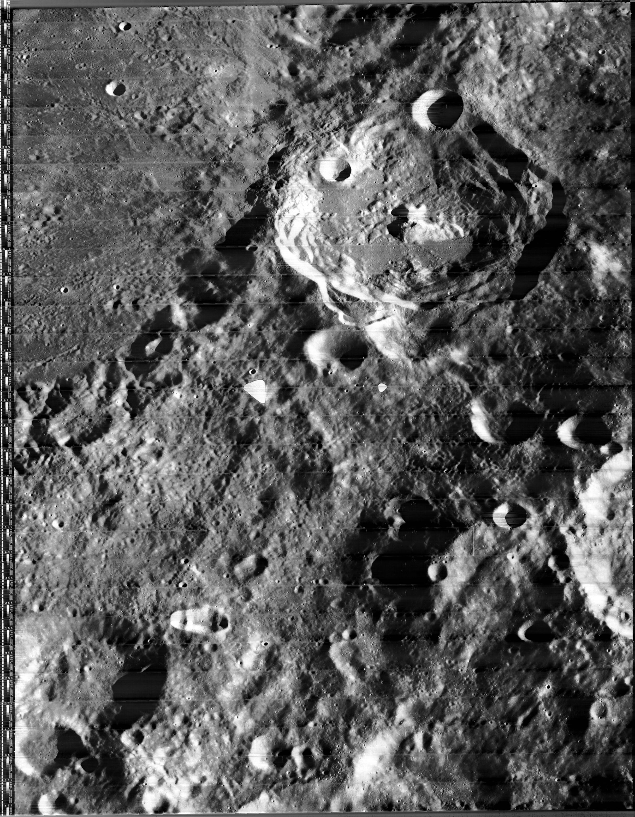
LROC image WAC No. M118823820ME. Calibrated by LROC_WAC_Previewer.
Images
LPOD Photo Gallery Lunar Orbiter Images Apollo Images
LO-II 075 h3 is a HiRes scan of Lunar Orbiter II's detailed photograph of O'Day (upper part of photograph, south up), with a curious elongated depression near the photograph's lower left corner (called Barbier K)(according to LAC 103 in the Clementine Atlas of the Moon).
Additional research: Danny Caes
Maps
Description
Wikipedia
Additional Information
- IAU page: O'Day
- Originally mapped as Copernican because it has rays but these are compositional rays (highlands material) thatt have reached full optical maturity and thus are older than Copernicus; O'Day is Eratosthenian age. (Hawke et al: Composition and origin of Copernican Rays… Mappers Conference 2005).
- Maximum depth read from LM map; seems too deep.
- Central peak composition: A, GNTA1 & GNTA2 (Tompkins & Pieters, 1999)
- Exterior impact melt deposits most extensive to ESE, max of ~30 km beyond rim. Most extensive ejecta, rays and secondary craters to the SE, with max wall slumping on W side of crater, and topographically lowest rim crest to SE (Hawke and Head, 1977).
Nomenclature
Marcus Driver O'Day (1897 – 1961) was an American physicist. In 1946 and 1947 he guided a team that worked to launch scientific payloads into the ionosphere using V-2 rockets. He would theorize in 1958 that solar power could be used to sustain a colony on the Moon, and hypothesized that there may be water under the lunar surface.
LPOD Articles
Bibliography
Named Features -- Prev: Obruchev -- Next: Lacus Odii
This page has been edited 1 times. The last modification was made by - tychocrater tychocrater on Jun 13, 2009 3:24 pm - afx3u3