Difference between revisions of "Moretus"
(Created page with "<div id="content_view" class="wiki" style="display: block"> =Moretus= {| class="wiki_table" | Lat: 70.6°S, Long: 5.8°W, Diam: 111 km, Depth: 5.24 km, Rükl: 73, [/Strati...") |
|||
| (4 intermediate revisions by the same user not shown) | |||
| Line 3: | Line 3: | ||
{| class="wiki_table" | {| class="wiki_table" | ||
| | | | ||
| − | Lat: 70.6°S, Long: 5.8°W, Diam: 111 km, Depth: 5.24 km, Rükl: 73, [ | + | Lat: 70.6°S, Long: 5.8°W, Diam: 111 km, Depth: 5.24 km, Rükl: 73, [[Stratigraphy|Eratosthenian]]<br /> |
|} | |} | ||
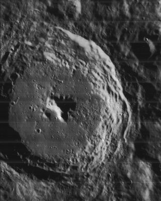
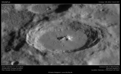
| − | [http://www.lpod.org/coppermine/displayimage.php?pid=2240&fullsize=1 [[Image: | + | [http://www.lpod.org/coppermine/displayimage.php?pid=2240&fullsize=1 [[Image:Normal_Moretus-LO-4130-h2.jpg|external image normal_Moretus-LO-4130-h2.jpg]]][http://www.lpod.org/coppermine/albums/userpics/moretus2006-10-12a.jpg [[Image:Normal_moretus2006-10-12a.jpg|external image normal_moretus2006-10-12a.jpg]]]<br /> '''Left''': ''[http://lpod.org/coppermine/displayimage.php?pos=-2240 Lunar Orbiter IV-130-h2]'' South-up overhead view. The small deeply shadowed crater in the upper right is 17-km diameter '''Moretus C'''.<br /> '''Right''': ''[http://lpod.org/coppermine/displayimage.php?pos=-1008 Mario Weigand]'' The greater visibility of '''Moretus'''’ upper rim indicates that south is also up (and east to the left) in this Earth-based view. The shadowed crater above (south of) '''Moretus''' is [[Short|Short]].<br /> <br /> <div id="toc"> |
| − | + | ||
| − | |||
==Images== | ==Images== | ||
| − | [http://www.lpod.org/coppermine/thumbnails.php?album=search&type=full&search=Moretus LPOD Photo Gallery] [http://www.planetmoon.org/atlas%20moretus.htm UAI Images] [http://www.lpi.usra.edu/resources/lunar_orbiter/bin/srch_nam.shtml?Moretus%7C0 Lunar Orbiter Images] [ | + | [http://www.lpod.org/coppermine/thumbnails.php?album=search&type=full&search=Moretus LPOD Photo Gallery] [http://www.planetmoon.org/atlas%20moretus.htm UAI Images] [http://www.lpi.usra.edu/resources/lunar_orbiter/bin/srch_nam.shtml?Moretus%7C0 Lunar Orbiter Images] [[South%20Pole-C|Southpole radar view, alphabetically arranged map: Part C]] (Moretus' northern half) and [[South%20Pole-H|Part H]] (Moretus' southern half)<br /> - Although it is not mentioned in the LPI's search-list of orbital Apollo photographs, the crater called '''Moretus''' WAS photographed during the mission of Apollo 15. It was captured near the lower part of the curved horizon in frame [http://www.lpi.usra.edu/resources/apollo/frame/?AS15-95-12988 AS15-95-12988] (look for the crater with the central peak).<br /> - Research: Danny Caes.<br /> <br /> |
==Maps== | ==Maps== | ||
| − | ''([ | + | ''([[LAC%20zone|LAC zone]] 137B4)'' [http://planetarynames.wr.usgs.gov/images/Lunar/lac_137.pdf USGS Digital Atlas PDF]<br /> <br /> |
==Description== | ==Description== | ||
<br /> | <br /> | ||
==Description: Elger== | ==Description: Elger== | ||
| − | ''([ | + | ''([[IAU%20directions|IAU Directions]])'' MORETUS.--A magnificent object, 78 miles in diameter, but foreshortened into a flat ellipse. Its beautifully terraced walls and magnificent central mountain, nearly 7,000 feet high, are very conspicuous under suitable conditions. The rampart on the W. is more than 15,000 feet above the floor, while on the opposite side it is about 5000 feet lower.<br /> <br /> |
==Description: Wikipedia== | ==Description: Wikipedia== | ||
[http://en.wikipedia.org/wiki/Moretus_(crater) Moretus]<br /> <br /> | [http://en.wikipedia.org/wiki/Moretus_(crater) Moretus]<br /> <br /> | ||
==Additional Information== | ==Additional Information== | ||
| − | * Depth data from [ | + | * Depth data from [[Kurt%20Fisher%20Crater%20Depths|Kurt Fisher database]] |
** Westfall, 2000: 5.24 km | ** Westfall, 2000: 5.24 km | ||
** Viscardy, 1985: 5 km | ** Viscardy, 1985: 5 km | ||
** Cherrington, 1969: 4.2 km | ** Cherrington, 1969: 4.2 km | ||
| − | * The shadow-casting central peak of '''Moretus''' is one of the perennial favorites of amateur lunar photography. The best available estimates of its height are from the [ | + | * The shadow-casting central peak of '''Moretus''' is one of the perennial favorites of amateur lunar photography. The best available estimates of its height are from the [[Lunar%20Orbiter|Lunar Orbiter]] IV photographs, in which the shadows are cast to the west, onto the rougher part of the floor. As measured by [[LTVT|LTVT]], [http://www.lpi.usra.edu/resources/lunarorbiter/frame/?4118 LO-IV-118H] gives a maximum height difference of about 2775 m. Slightly lower values (~2600 m) are obtained from [http://www.lpi.usra.edu/resources/lunarorbiter/frame/?4106 LO-IV-106H] and [http://www.lpi.usra.edu/resources/lunarorbiter/frame/?4130 130H], where the shadow tip probably falls on higher terrain. Amateur photos showing shadows cast to the east give similar results, but with insufficient precision to be able to know if there is a systematic difference compared to the westward shadows. Elger’s estimate of less than 7000 ft (2100 m) seems a little low. <span class="membersnap">- JimMosher</span> |
| − | * As for all craters of this size, there is no single value for the height of Moretus’ rim above the crater floor. [http://www.lpi.usra.edu/resources/lunarorbiter/frame/?4106 LO-IV-106H] provides good shadows cast by the east rim and indicates elevation differences of 4000 to 5250 m to the floor. Amateur and ''[ | + | * As for all craters of this size, there is no single value for the height of Moretus’ rim above the crater floor. [http://www.lpi.usra.edu/resources/lunarorbiter/frame/?4106 LO-IV-106H] provides good shadows cast by the east rim and indicates elevation differences of 4000 to 5250 m to the floor. Amateur and ''[[Consolidated%20Lunar%20Atlas|Consolidated Lunar Atlas]]'' photos taken with a similarly low sun angle from the west suggest that rim is a bit lower, ranging from about 3400-4700 m above the floor. This is opposite to Elger’s belief that the west rim is higher than the east, and the magnitude of the difference seems less than he suggests. The shadow technique cannot be used to evaluate the heights of the north or south rims. <span class="membersnap">- JimMosher</span> |
| − | * [ | + | * [[Radar%20bright|Radar bright]] at 70 cm. |
<br /> | <br /> | ||
==Nomenclature== | ==Nomenclature== | ||
* Named for Théodore Moret, also known as [http://en.wikipedia.org/wiki/Th%C3%A9odore_Moretus Moretus] (1602 – 1667), a Belgian mathematician and Jesuit. Moretus is the author of the first mathematical dissertations ever defended in Prague. | * Named for Théodore Moret, also known as [http://en.wikipedia.org/wiki/Th%C3%A9odore_Moretus Moretus] (1602 – 1667), a Belgian mathematician and Jesuit. Moretus is the author of the first mathematical dissertations ever defended in Prague. | ||
| − | * This name has continued unchanged since its original use for this feature on [ | + | * This name has continued unchanged since its original use for this feature on [[Riccioli|Riccioli]]'s map (''[[Whitaker|Whitaker]]'', p. 213), except that it was there labeled '''Moretus Soc. I''', the '''Soc. I''' meaning "Society of Jesus" (see [[Nomenclature-Jesuits|Nomenclature-Jesuits]]). |
<br /> | <br /> | ||
==LPOD Articles== | ==LPOD Articles== | ||
| − | [http:// | + | [http://www2.lpod.org/wiki/November_13,_2006 The Bottom of the World, Upside Down.] [http://www2.lpod.org/wiki/October_21,_2006 Mountains Near the South Pole.] [http://www2.lpod.org/wiki/September_29,_2004 Mountains at the Pole] [http://www2.lpod.org/wiki/June_27,_2004 An Older Tycho] [http://www2.lpod.org/wiki/March_5,_2007 Ring Eclipse] [http://www2.lpod.org/wiki/January_6,_2007 On Top of the World] [http://www2.lpod.org/wiki/August_1,_20079 A Scarp and a Rille][http://lpod.wikispaces.com/July%204%2C%202009 No Z] (alphabetically arranged map of the moon's southpole region, Hi-Res radar view, including <u>Moretus</u>)<br /> <br /> |
==Bibliography== | ==Bibliography== | ||
| − | * Harold Hill. ''[ | + | * Harold Hill. ''[[A%20Portfolio%20of%20Lunar%20Drawings|A Portfolio of Lunar Drawings]]'', pages 122, 123, 124. |
<br /> | <br /> | ||
---- | ---- | ||
| − | + | </div> | |
Latest revision as of 21:27, 16 April 2018
Contents
Moretus
|
Lat: 70.6°S, Long: 5.8°W, Diam: 111 km, Depth: 5.24 km, Rükl: 73, Eratosthenian |


Left: Lunar Orbiter IV-130-h2 South-up overhead view. The small deeply shadowed crater in the upper right is 17-km diameter Moretus C.
Right: Mario Weigand The greater visibility of Moretus’ upper rim indicates that south is also up (and east to the left) in this Earth-based view. The shadowed crater above (south of) Moretus is Short.
Images
LPOD Photo Gallery UAI Images Lunar Orbiter Images Southpole radar view, alphabetically arranged map: Part C (Moretus' northern half) and Part H (Moretus' southern half)
- Although it is not mentioned in the LPI's search-list of orbital Apollo photographs, the crater called Moretus WAS photographed during the mission of Apollo 15. It was captured near the lower part of the curved horizon in frame AS15-95-12988 (look for the crater with the central peak).
- Research: Danny Caes.
Maps
(LAC zone 137B4) USGS Digital Atlas PDF
Description
Description: Elger
(IAU Directions) MORETUS.--A magnificent object, 78 miles in diameter, but foreshortened into a flat ellipse. Its beautifully terraced walls and magnificent central mountain, nearly 7,000 feet high, are very conspicuous under suitable conditions. The rampart on the W. is more than 15,000 feet above the floor, while on the opposite side it is about 5000 feet lower.
Description: Wikipedia
Additional Information
- Depth data from Kurt Fisher database
- Westfall, 2000: 5.24 km
- Viscardy, 1985: 5 km
- Cherrington, 1969: 4.2 km
- The shadow-casting central peak of Moretus is one of the perennial favorites of amateur lunar photography. The best available estimates of its height are from the Lunar Orbiter IV photographs, in which the shadows are cast to the west, onto the rougher part of the floor. As measured by LTVT, LO-IV-118H gives a maximum height difference of about 2775 m. Slightly lower values (~2600 m) are obtained from LO-IV-106H and 130H, where the shadow tip probably falls on higher terrain. Amateur photos showing shadows cast to the east give similar results, but with insufficient precision to be able to know if there is a systematic difference compared to the westward shadows. Elger’s estimate of less than 7000 ft (2100 m) seems a little low. - JimMosher
- As for all craters of this size, there is no single value for the height of Moretus’ rim above the crater floor. LO-IV-106H provides good shadows cast by the east rim and indicates elevation differences of 4000 to 5250 m to the floor. Amateur and Consolidated Lunar Atlas photos taken with a similarly low sun angle from the west suggest that rim is a bit lower, ranging from about 3400-4700 m above the floor. This is opposite to Elger’s belief that the west rim is higher than the east, and the magnitude of the difference seems less than he suggests. The shadow technique cannot be used to evaluate the heights of the north or south rims. - JimMosher
- Radar bright at 70 cm.
Nomenclature
- Named for Théodore Moret, also known as Moretus (1602 – 1667), a Belgian mathematician and Jesuit. Moretus is the author of the first mathematical dissertations ever defended in Prague.
- This name has continued unchanged since its original use for this feature on Riccioli's map (Whitaker, p. 213), except that it was there labeled Moretus Soc. I, the Soc. I meaning "Society of Jesus" (see Nomenclature-Jesuits).
LPOD Articles
The Bottom of the World, Upside Down. Mountains Near the South Pole. Mountains at the Pole An Older Tycho Ring Eclipse On Top of the World A Scarp and a RilleNo Z (alphabetically arranged map of the moon's southpole region, Hi-Res radar view, including Moretus)
Bibliography
- Harold Hill. A Portfolio of Lunar Drawings, pages 122, 123, 124.