Difference between revisions of "Mare Humorum"
(Created page with "<div id="content_view" class="wiki" style="display: block"> =Humorum Basin= ''(unofficial name; IAU feature name for central 389 km of mare: '''Mare Humorum''' )''<br /> {...") |
|||
| (3 intermediate revisions by the same user not shown) | |||
| Line 4: | Line 4: | ||
{| class="wiki_table" | {| class="wiki_table" | ||
| | | | ||
| − | Lat: 24.4°S, Long: 38.6°W, Main ring diam: 425 km, Basin depth: 2.24 km, [ | + | Lat: 24.4°S, Long: 38.6°W, Main ring diam: 425 km, Basin depth: 2.24 km, [[R%C3%BCkl%2052|Rükl: 52]]<br /> |
|} | |} | ||
| − | [http://www.lpod.org/coppermine/displayimage.php?pid=227&fullsize=1 [[Image: | + | [http://www.lpod.org/coppermine/displayimage.php?pid=227&fullsize=1 [[Image:Normal_Mare%20Humorum.jpg|external image normal_Mare%20Humorum.jpg]]][http://www.lpod.org/coppermine/displayimage.php?pid=2327&fullsize=1 [[Image:Normal_Humorum_Basin_LIDAR_LTVT.JPG|external image normal_Humorum_Basin_LIDAR_LTVT.JPG]]]<br /> '''Left:''' ''[http://lpod.org/coppermine/displayimage.php?pos=-227 Dave Storey]'', The Isle of Man Observatory; 9 Feb. 2006 22:43 UT.<br /> '''Right:''' ''[http://lpod.org/coppermine/displayimage.php?pos=-2327 Clementine]'', Clementine LIDAR Altimeter texture from [http://pdsmaps.wr.usgs.gov/PDS/public/explorer/html/lidrlvls.htm PDS Map-a-Planet] remapped to north-up aerial view by [http://www.henriksucla.dk/ LTVT]. The dot is the center position and the white circle the main ring position from Chuck Wood's [http://www.lpod.org/cwm/DataStuff/Lunar%20Basins.htm Impact Basin Database]. Grid spacing = 10 degrees.<br /> <br /> <div id="toc"> |
| − | + | ||
| − | |||
==Images== | ==Images== | ||
[http://www.lpod.org/coppermine/thumbnails.php?album=search&type=full&search=Mare%20Humorum LPOD Photo Gallery] [http://www.lpi.usra.edu/resources/lunar_orbiter/bin/srch_nam.shtml?Mare%20Humorum%7C0 Lunar Orbiter Images] [http://www.lpi.usra.edu/resources/apollo/search/feature/?feature=Mare%20Humorum Apollo Images]<br /> | [http://www.lpod.org/coppermine/thumbnails.php?album=search&type=full&search=Mare%20Humorum LPOD Photo Gallery] [http://www.lpi.usra.edu/resources/lunar_orbiter/bin/srch_nam.shtml?Mare%20Humorum%7C0 Lunar Orbiter Images] [http://www.lpi.usra.edu/resources/apollo/search/feature/?feature=Mare%20Humorum Apollo Images]<br /> | ||
| − | * An 1875 [http://www.lib.umich.edu/science/astro/maps/drawings_work7.html pastel drawing] of '''Mare Humorum''' by [ | + | * An 1875 [http://www.lib.umich.edu/science/astro/maps/drawings_work7.html pastel drawing] of '''Mare Humorum''' by [[Trouvelot|Etiénne Trouvelot]]. Trouvelot's description of the features depicted in this drawing can be found on pp. 51-52 and again on pp. 162-163 of the ''[http://books.google.com/books?output=text&id=HKUMAAAAYAAJ Manual]'' that accompanied the plates. |
<br /> | <br /> | ||
==Maps== | ==Maps== | ||
| − | ''([ | + | ''([[LAC%20zone|LAC zone]] 93C1)'' [http://www.lpi.usra.edu/resources/mapcatalog/LAC/lac93/ LAC map] [http://www.lpi.usra.edu/resources/mapcatalog/usgs/I495/ Geologic map]<br /> <br /> |
| − | ==[ | + | ==[[Lunar%20Basins|Basin Classification]]== |
(description of terms and most numeric basin data from Wood, C.A. (2004) [http://www.lpod.org/cwm/DataStuff/Lunar%20Basins.htm Impact Basin Database])<br /> | (description of terms and most numeric basin data from Wood, C.A. (2004) [http://www.lpod.org/cwm/DataStuff/Lunar%20Basins.htm Impact Basin Database])<br /> | ||
{| class="wiki_table" | {| class="wiki_table" | ||
| Line 39: | Line 38: | ||
==Additional Information== | ==Additional Information== | ||
| − | * Depth data from [ | + | * Depth data from [[Kurt%20Fisher%20Crater%20Depths|Kurt Fisher database]] |
** Cherrington, 1969: 1.49 km | ** Cherrington, 1969: 1.49 km | ||
* Mare area of 84,500 km^2 according to measurements by [http://www.lpod.org/cwm/DataStuff/MareAreas.htm Jim Whitford-Stark]. | * Mare area of 84,500 km^2 according to measurements by [http://www.lpod.org/cwm/DataStuff/MareAreas.htm Jim Whitford-Stark]. | ||
| Line 46: | Line 45: | ||
The IAU feature name means "Sea of Moisture".<br /> | The IAU feature name means "Sea of Moisture".<br /> | ||
| − | * Called '''Anticaspia''' (Opposite the Capspian) by Gassendi (who called Mare Crisium '''Caspia'''). ([ | + | * Called '''Anticaspia''' (Opposite the Capspian) by Gassendi (who called Mare Crisium '''Caspia'''). ([[Whitaker|Whitaker]]: ''Mapping and Naming the Moon'', p 33). |
* The impact basin is named for the mare. | * The impact basin is named for the mare. | ||
* The western rim of '''Mare Humorum''' was once called the '''Percy mountains''' by William Radcliff Birt, but the I.A.U. did not accept that name. | * The western rim of '''Mare Humorum''' was once called the '''Percy mountains''' by William Radcliff Birt, but the I.A.U. did not accept that name. | ||
| Line 61: | Line 60: | ||
* '''''Dorsa Kelvin''''': the arc-shaped system of wrinkle ridges on the eastern part of '''Mare Humorum''', near '''Promontorium Kelvin'''. | * '''''Dorsa Kelvin''''': the arc-shaped system of wrinkle ridges on the eastern part of '''Mare Humorum''', near '''Promontorium Kelvin'''. | ||
* '''''Dorsum Doppelmayer J''''': the wrinkle ridge north-northwest of '''Doppelmayer J''' at '''Mare Humorum''''s western part. | * '''''Dorsum Doppelmayer J''''': the wrinkle ridge north-northwest of '''Doppelmayer J''' at '''Mare Humorum''''s western part. | ||
| − | <span class="membersnap">- | + | <span class="membersnap">- DannyCaes <small>Nov 1, 2014</small></span><br /> <br /> |
==LROC Articles== | ==LROC Articles== | ||
| Line 69: | Line 68: | ||
==LPOD Articles== | ==LPOD Articles== | ||
| − | * [http:// | + | * [http://www2.lpod.org/wiki/November_22,_2006 Making Rilles Visible.] |
| − | * [http:// | + | * [http://www2.lpod.org/wiki/June_8,_2006 Ring the Bell] |
| − | * [http:// | + | * [http://www2.lpod.org/wiki/August_20,_2004 Humor More My Fault][http://www2.lpod.org/wiki/June_6,_2004 Sea of Dryness] |
| − | * [ | + | * [[LPOD%20Feb%208%2C%202008|Humor Me Once More]] |
<br /> | <br /> | ||
==Bibliography== | ==Bibliography== | ||
| − | * Hill, Harold. 1991. [ | + | * Hill, Harold. 1991. [[Hill%2C%201991|A Portfolio of Lunar Drawings]]., pages 135, 136 (the "Percy mountains") -"Percy mountains": [[Whitaker|Whitaker]] (page 221, Appendix J). |
<br /> | <br /> | ||
---- | ---- | ||
| − | + | </div> | |
Latest revision as of 03:03, 16 April 2018
Contents
Humorum Basin
(unofficial name; IAU feature name for central 389 km of mare: Mare Humorum )
|
Lat: 24.4°S, Long: 38.6°W, Main ring diam: 425 km, Basin depth: 2.24 km, Rükl: 52 |


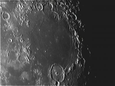
Left: Dave Storey, The Isle of Man Observatory; 9 Feb. 2006 22:43 UT.
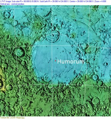
Right: Clementine, Clementine LIDAR Altimeter texture from PDS Map-a-Planet remapped to north-up aerial view by LTVT. The dot is the center position and the white circle the main ring position from Chuck Wood's Impact Basin Database. Grid spacing = 10 degrees.
Images
LPOD Photo Gallery Lunar Orbiter Images Apollo Images
- An 1875 pastel drawing of Mare Humorum by Etiénne Trouvelot. Trouvelot's description of the features depicted in this drawing can be found on pp. 51-52 and again on pp. 162-163 of the Manual that accompanied the plates.
Maps
(LAC zone 93C1) LAC map Geologic map
Basin Classification
(description of terms and most numeric basin data from Wood, C.A. (2004) Impact Basin Database)
| Certainty of Existence |
USGS Age |
Wilhelms Age Group |
Ring Diameters |
Mare Thickness |
Mascon |
| Certain |
Nectarian |
11 |
210, 340, 425, 570, 800, 1195 |
3.61 |
Yes |
Description
Wikipedia
Additional Information
- Depth data from Kurt Fisher database
- Cherrington, 1969: 1.49 km
- Mare area of 84,500 km^2 according to measurements by Jim Whitford-Stark.
Nomenclature
The IAU feature name means "Sea of Moisture".
- Called Anticaspia (Opposite the Capspian) by Gassendi (who called Mare Crisium Caspia). (Whitaker: Mapping and Naming the Moon, p 33).
- The impact basin is named for the mare.
- The western rim of Mare Humorum was once called the Percy mountains by William Radcliff Birt, but the I.A.U. did not accept that name.
- The trio of craterlets at centre of Mare Humorum's basin are nicknamed Mare Humorum's triplet by D.Caes (Doppelmayer J, K, and L).
The abundance of White Spots on the wrinkle ridges of Mare Humorum
To try to find your way on the floor of Mare Humorum is a tricky business, because none of the wrinkle ridges up here have names. Moonobserver Danny Caes decided to include some sort of unofficial nomenclature system (see list below).
 Why an additional nomenclature system for wrinkle ridges in Mare Humorum?
  The LROC's High-Res NAC close up photographs of Mare Humorum reveal curious chains of White Spots on the uppermost parts of its wrinkle ridges. Each one of these White Spots is composed of a large number of high-albedo boulders and rocks. These small compact fields of "white" boulders and rocks must be quite a strange experience for astronauts who want to explore these odd spots. Another peculiar fact of these boulder-rich fields is their sharp boundaries. An astronaut would cross a flat featureless low-albedo region to enter (abruptly) a "lunar wood" of high-albedo boulders and rocks! One could call these White Spots lunar labyrinths composed of irregular white walls!
 Catalog of wrinkle ridges in Mare Humorum
- Dorsum Puiseux D: the pronounced wrinkle ridge at the eastern part of Mare Humorum, with crater Puiseux D about "halfway" on the ridge.
- Puiseux D North: the northern part of Dorsum Puiseux D.
- Puiseux D South: the southern (or southwestern) part of Dorsum Puiseux D (from Puiseux D to Puiseux G).
- Gassendi Southeast: the pronounced wrinkle ridge from Gassendi to Gassendi O.
- Gassendi Southwest: the curved wrinkle ridge southwest of Gassendi.
- Dorsa Kelvin: the arc-shaped system of wrinkle ridges on the eastern part of Mare Humorum, near Promontorium Kelvin.
- Dorsum Doppelmayer J: the wrinkle ridge north-northwest of Doppelmayer J at Mare Humorum's western part.
- DannyCaes Nov 1, 2014
LROC Articles
LPOD Articles
Bibliography
- Hill, Harold. 1991. A Portfolio of Lunar Drawings., pages 135, 136 (the "Percy mountains") -"Percy mountains": Whitaker (page 221, Appendix J).