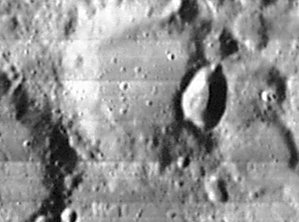
Kaiser
Contents
Kaiser
|
Lat: 36.5°S, Long: 6.5°E, Diam: 52 km, Depth: 1.06 km, Rükl: 66 |
Table of Contents
[#Kaiser Kaiser]
[#Kaiser-Images Images]
[#Kaiser-Maps Maps]
[#Kaiser-Description Description]
[#Kaiser-Description: Wikipedia Description: Wikipedia]
[#Kaiser-Additional Information Additional Information]
[#Kaiser-Nomenclature Nomenclature]
[#Kaiser-LPOD Articles LPOD Articles]
[#Kaiser-Bibliography Bibliography]
 LOIV 107 H2
Images
LPOD Photo Gallery Lunar Orbiter Images Apollo Images
Maps
(LAC zone 112B3) LAC map Geologic map
Description
Description: Wikipedia
Additional Information
Depth data from Kurt Fisher database
- Westfall, 2000: 1.06 km
- Cherrington, 1969: 1.98 km
- Satellite crater Kaiser C is on the ALPO list of bright ray craters.
- Satellite crater Kaiser C is on the ALPO list of banded craters
Nomenclature
- Frederik Kaiser (June 10, 1808 – July 28, 1872) was a Dutch astronomer. He is credited with the advancement of Dutch astronomy through his world-class scientific contributions of positional measurements, his successful popularization of astronomy in the Netherlands, and by helping to build a state-of-the-art observatory in 1861.
  - Kaiser seems to have been a possible name for the bowl shaped high-albedo crater Mosting A (number 498), see W.R.Birt, august 1873.- DannyCaes DannyCaes May 19, 2013
LPOD Articles
Bibliography
This page has been edited 1 times. The last modification was made by - tychocrater tychocrater on Jun 13, 2009 3:24 pm - afx3u2