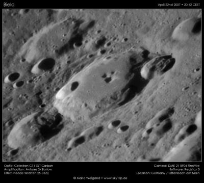
Biela
Contents
Biela
|
Lat: 54.9°S, Long: 51.3°E, Diam: 76 km, Depth: 5.55 km, Rükl: 75 |
Table of Contents
[#Biela Biela]
[#Biela-Images Images]
[#Biela-Maps Maps]
[#Biela-Description Description]
[#Biela-Description: Elger Description: Elger]
[#Biela-Description: Wikipedia Description: Wikipedia]
[#Biela-Additional Information Additional Information]
[#Biela-Nomenclature Nomenclature]
[#Biela-LPOD Articles LPOD Articles]
[#Biela-Bibliography Bibliography]

Mario Weigand
Images
LPOD Photo Gallery Lunar Orbiter Images Apollo Images
Maps
(LAC zone 128A3) USGS Digital Atlas PDF
Description
Description: Elger
(IAU Directions) BIELA.--A considerable ring-plain, about 55 miles in diameter, S.E. of Janssen, with a wall broken on the N.E., S., and W. by rings and large enclosures. There is a central mountain, but apparently no other details on the floor.
Description: Wikipedia
Additional Information
- Depth data from Kurt Fisher database
- Westfall, 2000: 5.55 km
- Viscardy, 1985: 3.1 km
- Cherrington, 1969: 2.01 km
- Central peak height
- Wood, 1971: 1.09 km - tychocrater tychocrater Mar 17, 2008
Nomenclature
- Named for Wilhelm von Biela (March 19, 1782 – February 18, 1856), a German-Austrian amateur astronomer. He specialized in observing and calculating the orbits of comets. He also did some sunspot observations. He independently discovered some comets that others had already found, and made one independent discovery of his own: the lost periodic comet 3D/Biela.
LPOD Articles
Bibliography
This page has been edited 1 times. The last modification was made by - tychocrater tychocrater on Jun 13, 2009 3:24 pm - afx3u2