Difference between revisions of "Balandin"
(Created page with "<div id="content_view" class="wiki" style="display: block"> =Balandin - on the floor of Gagarin= {| class="wiki_table" | Lat: 18.9°S, Long: 152.6°E, Diam: 12 km, Depth: k...") |
|||
| (4 intermediate revisions by the same user not shown) | |||
| Line 4: | Line 4: | ||
| Lat: 18.9°S, Long: 152.6°E, Diam: 12 km, Depth: km, Rükl: ''(farside)''<br /> | | Lat: 18.9°S, Long: 152.6°E, Diam: 12 km, Depth: km, Rükl: ''(farside)''<br /> | ||
|} | |} | ||
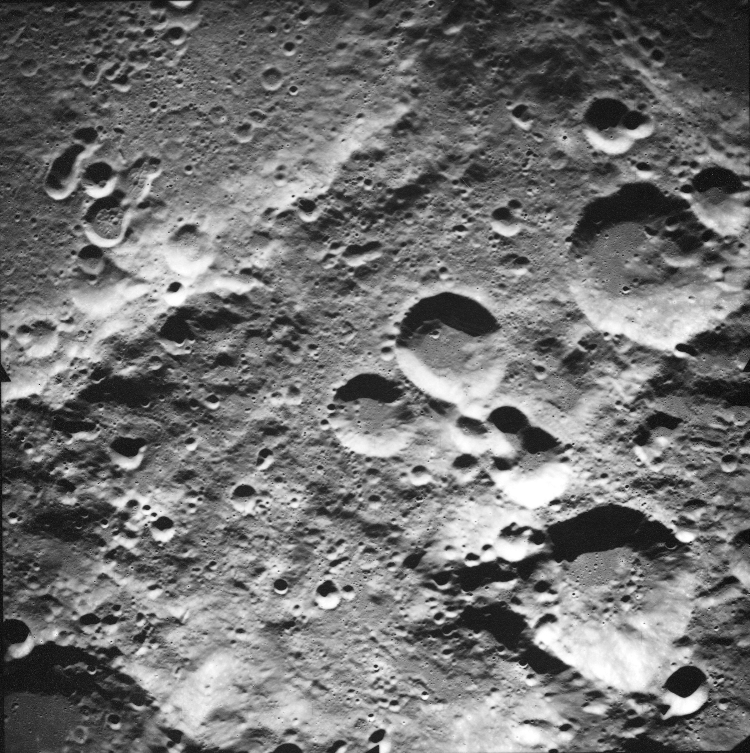
| − | [http://www.lpod.org/coppermine/displayimage.php?pid=4109&fullsize=1 [[Image: | + | [http://www.lpod.org/coppermine/displayimage.php?pid=4109&fullsize=1 [[Image:Balandin.jpg|balandin.jpg]]][[Image:Balandin-color.jpg|balandin-color.jpg]]<br /> (Left) ''[http://the-moon.us/wiki/file/detail/balandin.jpg Annotated]'' image based on Apollo frame [http://www.lpi.usra.edu/resources/apollo/frame/?AS17-M-1702 AS17-M-1702] (note: west is top, north is right in the linked image). (Right) [http://planetarynames.wr.usgs.gov/images/Lunar/lac_103.pdf Color-coded LAC 103] from the [[USGS%20Digital%20Atlas|USGS Digital Atlas]]<br /> <div id="toc"> |
| − | + | ||
| − | |||
==Images== | ==Images== | ||
[http://www.lpod.org/coppermine/thumbnails.php?album=search&type=full&search=Balandin LPOD Photo Gallery] [http://www.lpi.usra.edu/resources/lunar_orbiter/bin/srch_nam.shtml?Balandin%7C0 Lunar Orbiter Images] [http://www.lpi.usra.edu/resources/apollo/search/feature/?feature=Balandin Apollo Images]<br /> | [http://www.lpod.org/coppermine/thumbnails.php?album=search&type=full&search=Balandin LPOD Photo Gallery] [http://www.lpi.usra.edu/resources/lunar_orbiter/bin/srch_nam.shtml?Balandin%7C0 Lunar Orbiter Images] [http://www.lpi.usra.edu/resources/apollo/search/feature/?feature=Balandin Apollo Images]<br /> | ||
| Line 14: | Line 13: | ||
<br /> | <br /> | ||
==Maps== | ==Maps== | ||
| − | ''([ | + | ''([[LAC%20zone|LAC zone]] 103A1)'' [http://www.lpi.usra.edu/resources/mapcatalog/LM/lm103/ LM map] [http://www.lpi.usra.edu/resources/mapcatalog/LTO/lto103a1_1/ LTO map]<br /> <br /> |
==Description== | ==Description== | ||
| − | '''Balandin''' lies north-easterly on the not-so-leveled floor of [ | + | '''Balandin''' lies north-easterly on the not-so-leveled floor of [[Gagarin|Gagarin]] -- a 265 km diameter-wide crater that formed during the [[stratigraphy|pre-Nectarian]] period (4.6 to 3.92 bn years). The crater looks, to all intents and purposes, like a capital 'D' that has tipped over on its side. Is this D-like appearance the result of ejecta from another impact event nearby in the region covering over the northern portion of the rim, or, is '''Balandin''' the result of an oblique impact? Landfill material seems to have poured in from the odd-looking connecting feature just north-west of '''Balandin''' (perhaps, the result of two coalesced craters), and this has covered in over any peaks or clumps of rocks that may originally existed inside the crater. Only a few small craters lie within the 'hummocky-looking' floor of '''Balandin''' -- the largest being about 1 and 1/2 metres across, however, there also is a hint of a buried rille that seems to extend into the odd-looking feature already mentioned in the north-west? <span class="membersnap">- JohnMoore2</span><br /> <br /> |
==Description: Wikipedia== | ==Description: Wikipedia== | ||
[http://en.wikipedia.org/wiki/Balandin_(crater) Balandin]<br /> <br /> | [http://en.wikipedia.org/wiki/Balandin_(crater) Balandin]<br /> <br /> | ||
| Line 24: | Line 23: | ||
* Named for [http://en.wikipedia.org/wiki/Aleksei_Balandin Aleksey Aleksandrovich Balandin] (December 20, 1898 - May 22, 1967), a Soviet chemist. His primary contribution lies in the field of organic catalysis. He is the author of ''Multiplet Theory of Catalysis'' (1929). | * Named for [http://en.wikipedia.org/wiki/Aleksei_Balandin Aleksey Aleksandrovich Balandin] (December 20, 1898 - May 22, 1967), a Soviet chemist. His primary contribution lies in the field of organic catalysis. He is the author of ''Multiplet Theory of Catalysis'' (1929). | ||
| − | * This is among 120 names appearing on [ | + | * This is among 120 names appearing on [[LTO|LTO]] charts that were approved by the [[IAU|IAU]] in [[IAU%20Transactions%20XVIB|1976]]. |
<br /> | <br /> | ||
==LPOD Articles== | ==LPOD Articles== | ||
| Line 31: | Line 30: | ||
<br /> <br /> | <br /> <br /> | ||
---- | ---- | ||
| − | + | </div> | |
Latest revision as of 21:00, 16 April 2018
Contents
Balandin - on the floor of Gagarin
| Lat: 18.9°S, Long: 152.6°E, Diam: 12 km, Depth: km, Rükl: (farside) |


(Left) Annotated image based on Apollo frame AS17-M-1702 (note: west is top, north is right in the linked image). (Right) Color-coded LAC 103 from the USGS Digital Atlas
Images
LPOD Photo Gallery Lunar Orbiter Images Apollo Images
- Large printable version of AS17-M-1702.
- Balandin and its cluster of rather unusual neighbours is also captured near the left margin of Apollo 17's orbital ITEK-panoramic frame AS17-P-2370. Research: Danny Caes
- The right half of Apollo 15's orbital ITEK-panoramic frame AS15-P-8913 shows a close up of Balandin. Research: Danny Caes
Maps
(LAC zone 103A1) LM map LTO map
Description
Balandin lies north-easterly on the not-so-leveled floor of Gagarin -- a 265 km diameter-wide crater that formed during the pre-Nectarian period (4.6 to 3.92 bn years). The crater looks, to all intents and purposes, like a capital 'D' that has tipped over on its side. Is this D-like appearance the result of ejecta from another impact event nearby in the region covering over the northern portion of the rim, or, is Balandin the result of an oblique impact? Landfill material seems to have poured in from the odd-looking connecting feature just north-west of Balandin (perhaps, the result of two coalesced craters), and this has covered in over any peaks or clumps of rocks that may originally existed inside the crater. Only a few small craters lie within the 'hummocky-looking' floor of Balandin -- the largest being about 1 and 1/2 metres across, however, there also is a hint of a buried rille that seems to extend into the odd-looking feature already mentioned in the north-west? - JohnMoore2
Description: Wikipedia
Additional Information
Nomenclature
- Named for Aleksey Aleksandrovich Balandin (December 20, 1898 - May 22, 1967), a Soviet chemist. His primary contribution lies in the field of organic catalysis. He is the author of Multiplet Theory of Catalysis (1929).
- This is among 120 names appearing on LTO charts that were approved by the IAU in 1976.
LPOD Articles
Bibliography