Alpes
Contents
Montes Alpes
(current [/IAU IAU] name; formerly Alps)
|
Lat: 46.4°N, Long: 0.8°W, Diam: 281 km, Height: 2.4 km, [/R%C3%BCkl%2012 Rükl: 12] |
Table of Contents

LO-IV-115H This aerial view of the lunar Alps extends from [/Rimae%20Plato Rimae Plato] on the north to [/Promontorium%20Agassiz Promontorium Agassiz] on the south. The [/Alpine%20Valley Alpine Valley] is visible as the swordblade-like rift extending to the upper right. The isolated crater along the lower margin, in [/Mare%20Imbrium Mare Imbrium], is [/Piazzi%20Smyth Piazzi Smyth]. The sunlight peak on the left, once known as [/Mons%20Pico Pico] Beta, no longer has an official IAU-approved name.
Images
LPOD Photo Gallery Lunar Orbiter Images
- Spectacular close-up photographs of Montes Alpes (the part east of Plato) were made by Lunar Orbiter 5; Frames 129, 130, 131, and 132. Research Danny Caes.
- Although there seems to be nothing in the LPI's Apollo Images Search for the Montes Alpes and their most southern peaks such as Promontorium Agassiz and Promontorium Deville, there ARE orbital Apollo photographs of those peaks! For example: Fairchild-Metric image AS15-M-1538 which shows these peaks at the centre of the curved horizon! (north of Aristillus). Research Danny Caes.
Maps
([/LAC%20zone LAC zone] 25B1) LAC map Geologic map
Description
Description: Elger
([/IAU%20Directions IAU Directions]) THE ALPS.--include many hundred peaks, among which, Mont Blanc rises to a height of 12,000 feet, and a second, some distance east of [/Plato Plato], to nearly as great an altitude; while others, ranging from 5,000 to 8,000 feet, are common. They extend in a south-east direction from [/Plato Plato] to the [/Montes%20Caucasus Caucasus], terminating somewhat abruptly, a little east of the central meridian, in about N. lat. 42 deg. One of the most interesting features associated with this range is the so-called [/Vallis%20Alpes great Alpine valley], which cuts through it east of [/Plato Plato].
Description: Wikipedia
Additional Information
- Depth data from [/Kurt%20Fisher%20crater%20depths Kurt Fisher database]
- Viscardy, 1985: 2.4 km
- Cherrington, 1969: 3.65 km
Nomenclature
- Named from terrestrial Alps.
- According to [/Whitaker Whitaker] (p. 209), of the many names introduced by [/Hevelius Hevelius], Alpes is one of just ten that have survived into modern usage; and one of only four still used at the original location. [/Riccioli Riccioli] called this area Terra Grandinis. Since this the mountainous area was neither a [/mare mare] nor a measured point, neither name appears in Lichtenberg's index to features on the earlier map of [/Tobias%20Mayer Tobias Mayer], later reprinted by [/Johann%20Schr%C3%B6ter Johann Schröter]. Schröter placed Riccioli's designation on his drawing of the area, but in the text of Vol. I refers to the "Mondalpen" (Moon Alps) and "Alpengebirge" (Alpine Mountains), indicating he was aware of Hevelius' name for the formation. Use of Hevelius' designation returned to mainstream through its appearance in [/Beer%20and%20M%C3%A4dler Beer and Mädler], who rejected Riccioli's "Terra" names. - JimMosher JimMosher
- In the original [/IAU%20nomenclature IAU nomenclature] of [/Blagg%20and%20M%C3%BCller Blagg and Müller] Beer and Mädler's spelling was Anglicized to Alps (unlike the present IAU, Blagg and Müller recommended astronomers in different countries use their domestic spelling of common words). The 1935 nomenclature included two [/lettered%20craters lettered craters] having names derived from Alps: 11-km Alps A (called Plato A(2) in [/Beer%20and%20M%C3%A4dler Beer and Mädler])and 5-km Alps B (a previously unnamed crater) as well as the large "cleft" then called the [/Alpine%20Valley Alpine Valley]. The name Alps was apparently Latinized to Montes Alpes in the early 1960's, although that change does not appear to be explicitly mentioned in any of the [/IAU%20Transactions IAU Transactions]. - JimMosher JimMosher
- This [/LTVT LTVT]-generated diagram illustrates the current IAU-approved names sharing the primary name "Alpes" which differ from the 1935 ones only in spelling.
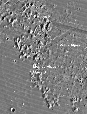 The background image is the USGS's [/Lunar%20Orbiter Lunar Orbiter] mosaic. The dots indicate the current "official" center positions listed in the [/IAU%20Planetary%20Gazetteer IAU Planetary Gazetteer]. As it was in 1935, the IAU nomenclature within the Alpes district continues to be quite confusing, with satellite features between Alpes A and Alpes B (not labeld on this map) assigned not to Montes Alpes but rather to [/Trouvelot Trouvelot] and the very distant [/Protagoras Protagoras].

LPOD Articles
Classic View
Charcoal Excursion
LROC Articles
Bibliography
This page has been edited 1 times. The last modification was made by - tychocrater tychocrater on Jun 13, 2009 3:24 pm - afx3u2 - mrx1