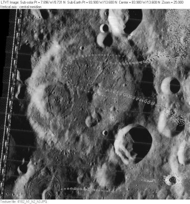
Vasco da Gama
Contents
Vasco da Gama
|
Lat: 13.6°N, Long: 83.9°W, Diam: 83 km, Depth: 2.78 km, Rükl: 28 |
Table of Contents

LO-IV-182H
Images
LPOD Photo Gallery Lunar Orbiter Images Apollo Images
Zond 7 (Vasco da Gama and environs, evening light).
Maps
(LAC zone 55A2) USGS Digital Atlas PDF
Description
Description: Elger
(IAU Directions) VASCO DE GAMA.--A bright enclosure, 51 miles in diameter, with a small central mountain. It is associated on the N. with a number of enclosed areas of a similar class, all too near the limb to be well seen.
Description: Wikipedia
Additional Information
Depth data from Kurt Fisher database
- Westfall, 2000: 2.78 km
- Viscardy, 1985: 2.1 km
- Cherrington, 1969: 2.1 km
Nomenclature
Dom Vasco da Gama (1460 - December 24, 1524) was a Portuguese explorer, one of the most successful in the European Age of Discovery and the commander of the first ships to sail directly from Europe to India. As much as anyone after Henry the Navigator, Gama was responsible for Portugal's success as an early colonising power. Beside the fact of the first voyage itself, it was his astute mix of politics and war on the other side of the world that placed Portugal in a prominent position in Indian Ocean trade.
- Erroneously printed as Vasco da Gamma (one extra "m") on page 77 (libration chart 6) in the 21st Century Atlas of the Moon (2012).- DannyCaes DannyCaes Jan 23, 2013
LPOD Articles
Bibliography
This page has been edited 1 times. The last modification was made by - tychocrater tychocrater on Jun 13, 2009 3:24 pm - afx3u2