Pallas
Contents
[hide]Pallas
|
Lat: 5.5°N, Long: 1.6°W, Diam: 46 km, Depth: 1.5 km, [/R%C3%BCkl%2033 Rükl 33] |
Table of Contents

LOIV-109H1
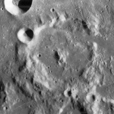
Pallas at centre of frame, the bowl-shaped crater Bode near the frame's upper left corner, part of Murchison at the frame's right margin.
Images
LPOD Photo Gallery Lunar Orbiter Images Apollo Images
Apollo 10's AS10-32-4821 shows both Pallas and Murchison near the lower margin of the frame.
Research Danny Caes
Maps
([/LAC%20zone LAC zone] 59D2) LAC map Geologic map AIC map
Description
Description: Elger
([/IAU%20Directions IAU Directions]) PALLAS.--A fine ring-plain, about 32 miles in diameter, forming with [/Murchison Murchison] an especially beautiful telescopic object under suitable illumination. Its brilliant border, broken by gaps on the E., where it abuts on [/Murchison Murchison], has a bright crater on the N.W., from which, following the curvature of the wall, and just below its crest, runs a valley in an westerly direction. There is a large bright central mountain on the floor, with a smaller elevation to the S. of it, and a ridge extending from the N. wall to near the centre. On the E., a section of the border is continued in a N. direction far beyond the limits of the formation; and on the S. it is connected with a small incomplete ring; on the W. of which, near the foot of the wall, is a somewhat smaller and much duskier enclosure.
Description: Wikipedia
Additional Information
Depth data from [/Kurt%20Fisher%20crater%20depths Kurt Fisher database]
- Pike, 1976: 1.5 km
- Arthur, 1974: 1.27 km
- Westfall, 2000: 1.5 km
- Viscardy, 1985: 1.26 km
- Cherrington, 1969: 1.76 km
Stuart's craterlet
On November 15, 1953, the physician and amateur astronomer Dr. Leon H. Stuart took a picture of the Moon that appeared to show a flare of light about 16 km southeast of Pallas. The flare was estimated to last for about 8–10 seconds. The report was published in a 1956 issue of The Strolling Astronomer, a newsletter. However the incident was dismissed by professionals of the period as more likely a meteoroid entering the Earth's atmosphere.
  Many years later Dr. Bonnie Buratti of JPL saw the photograph and decided to investigate. Assisted by a graduate student, she identified a 1.5 km. diameter crater imaged by the Clementine spacecraft. The crater has the correct size, shape, and albedo to match the expected impact energy. Some astronomers now agree that Dr. Stuart may indeed have photographed an asteroid impact on the Moon.
  (source: Wikipedia, page Pallas)
Nomenclature
Peter Simon Pallas (September 22, 1741 — September 8, 1811) was a German zoologist and botanist who worked in Russia. Stony-iron meteorite type Pallasite named after him.
LPOD Articles
Move Over Orbiter.
Rima Weird. LPOD (Repeat 8/24)
Rubbly Lineations
Bibliography
This page has been edited 1 times. The last modification was made by - tychocrater tychocrater on Jun 13, 2009 3:24 pm - afx4