Ching-Te
Contents
Ching-Te
(formerly Littrow BD)
|
Lat: 20.0°N, Long: 30.0°E, Diam: 4 km, Depth: 0.77 km, Rükl: 25 |
Table of Contents
[#Ching-Te Ching-Te]
[#Ching-Te-Images Images]
[#Ching-Te-Maps Maps]
[#Ching-Te-Description Description]
[#Ching-Te-Description: Wikipedia Description: Wikipedia]
[#Ching-Te-Additional Information Additional Information]
[#Ching-Te-Nomenclature Nomenclature]
[#Ching-Te-LPOD Articles LPOD Articles]
[#Ching-Te-Bibliography Bibliography]

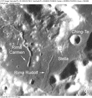
AS17-M-1220 Rima Carmen, Rima Rudolf and Stella are other IAU-approved names appearing on Topophotomap 42C3S3.
Images
LPOD Photo Gallery Lunar Orbiter Images Apollo Images
- Apollo 17's orbital panoramic ITEK-camera frame AS17-P-2311 shows Ching-Te during local morning illumination (scroll to the central part of the frame).
Research: Danny Caes
Maps
(LAC zone 43D4) LAC map Geologic map LTO map Topophotomap.
Description
The circular crater Ching-Te, and the other features shown in this image, lie just west of the Apollo 17 Site.
Description: Wikipedia
Additional Information
- Depth data from Kurt Fisher database
- Westfall, 2000: 0.77 km
Nomenclature
Chinese male name.
- According to NASA RP-1097, "Ching-Te" is a Minor Feature whose name was originally intended only for use in connection with Topophotomap 42C3/S3(on which it is plotted).
LPOD Articles
Bibliography
This page has been edited 1 times. The last modification was made by - tychocrater tychocrater on Jun 13, 2009 3:24 pm - afx3u2