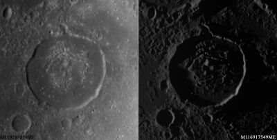
Warner
Contents
Warner
|
Lat: 4.02°S, Long: 87.33°E, Diam: 34.83 km, Depth: 0.25 km, [/R%C3%BCkl%2049 Rükl: 49] | |
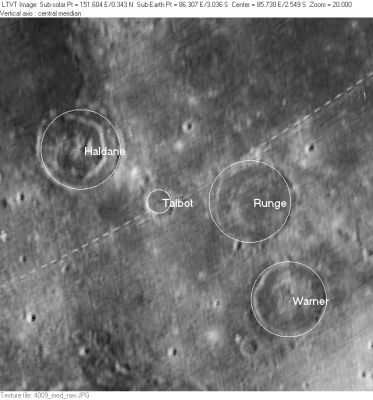
Right: LO-IV-009M This is an area that is poorly represented in any of the [/Lunar%20Orbiter Lunar Orbiter] images that are readily available on-line. The IAU-named features visible in this rectified version of a photo taken with the medium resolution camera are: [/Haldane Haldane], [/Talbot Talbot], [/Runge Runge], and [/Warner Warner].
Table of Contents
[#Warner Warner]
[#Warner-Images Images]
[#Warner-Maps Maps]
[#Warner-Description Description]
[#Warner-Description-Wikipedia Wikipedia]
[#Warner-Additional Information Additional Information]
[#Warner-Nomenclature Nomenclature]
[#Warner-LPOD Articles LPOD Articles]
[#Warner-Bibliography Bibliography]
Images
LPOD Photo Gallery Lunar Orbiter Images Apollo Images Web Map Service
- Warner was captured on oblique north-looking color Hasselblad frames made during the mission of Apollo 14 in february 1971. Frames AS14-72-10025 and AS14-72-10026 show Warner in the foreground and nearby Runge in the background.
- Research Apollo 14 photography: Danny Caes
Maps
([/LAC%20zone LAC zone] 81B3) LTO map
Description
Wikipedia
Additional Information
- IAU page: Warner
- Depth data from [/Kurt%20Fisher%20crater%20depths Kurt Fisher database]
- Pike, 1976: 0.25 km
- Westfall, 2000: 0.25 km
Nomenclature
Worcester Reed; American inventor (1846-1929).
- This name appears on LTO-81B3. It does not appear to replace any previous IAU-approved designation. Although it appears in the cumulative list of approved names printed in [/IAU%20Transactions%20XVB IAU Transactions XVB], when and how it came to be approved is not entirely clear from the IAU record. - JimMosher JimMosher
LPOD Articles
Bibliography
[/Alphabetical%20Index Named Features] -- Prev: [/Wargentin Wargentin] -- Next: [/Waterman Waterman]
This page has been edited 1 times. The last modification was made by - tychocrater tychocrater on Jun 13, 2009 3:24 pm - afx3u3

