Difference between revisions of "Celsius"
(Created page with "<div id="content_view" class="wiki" style="display: block"> =Celsius= {| class="wiki_table" | Lat: 34.1°S, Long: 20.1°E, Diam: 36 km, Depth: 2.11 km, [/R%C3%BCkl%2067 R...") |
|||
| Line 3: | Line 3: | ||
{| class="wiki_table" | {| class="wiki_table" | ||
| | | | ||
| − | Lat: 34.1°S, Long: 20.1°E, Diam: 36 km, Depth: 2.11 km, [ | + | Lat: 34.1°S, Long: 20.1°E, Diam: 36 km, Depth: 2.11 km, [[R%C3%BCkl%2067|Rükl: 67]]<br /> |
|} | |} | ||
<div id="toc"> | <div id="toc"> | ||
| Line 11: | Line 11: | ||
[http://www.lpod.org/coppermine/thumbnails.php?album=search&type=full&search=Celsius LPOD Photo Gallery] [http://www.lpi.usra.edu/resources/lunar_orbiter/bin/srch_nam.shtml?Celsius%7C0 Lunar Orbiter Images] [http://www.lpi.usra.edu/resources/apollo/search/feature/?feature=Celsius Apollo Images]<br /> <br /> | [http://www.lpod.org/coppermine/thumbnails.php?album=search&type=full&search=Celsius LPOD Photo Gallery] [http://www.lpi.usra.edu/resources/lunar_orbiter/bin/srch_nam.shtml?Celsius%7C0 Lunar Orbiter Images] [http://www.lpi.usra.edu/resources/apollo/search/feature/?feature=Celsius Apollo Images]<br /> <br /> | ||
==Maps== | ==Maps== | ||
| − | ''([ | + | ''([[LAC%20zone|LAC zone]] 113A2)'' [http://www.lpi.usra.edu/resources/mapcatalog/LAC/lac113/ LAC map] [http://www.lpi.usra.edu/resources/mapcatalog/usgs/I695/ Geologic map]<br /> <br /> |
==Description== | ==Description== | ||
<br /> | <br /> | ||
| Line 17: | Line 17: | ||
[http://en.wikipedia.org/wiki/Celsius_(crater) Celsius]<br /> <br /> | [http://en.wikipedia.org/wiki/Celsius_(crater) Celsius]<br /> <br /> | ||
==Additional Information== | ==Additional Information== | ||
| − | Depth data from [ | + | Depth data from [[Kurt%20Fisher%20crater%20depths|Kurt Fisher database]]<br /> |
* Westfall, 2000: 2.11 km | * Westfall, 2000: 2.11 km | ||
* Viscardy, 1985: 1.5 km | * Viscardy, 1985: 1.5 km | ||
Revision as of 14:43, 15 April 2018
Contents
Celsius
|
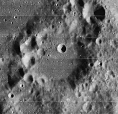
Lat: 34.1°S, Long: 20.1°E, Diam: 36 km, Depth: 2.11 km, Rükl: 67 |
Table of Contents
[#Celsius Celsius]
[#Celsius-Images Images]
[#Celsius-Maps Maps]
[#Celsius-Description Description]
[#Celsius-Description: Wikipedia Description: Wikipedia]
[#Celsius-Additional Information Additional Information]
[#Celsius-Nomenclature Nomenclature]
[#Celsius-LPOD Articles LPOD Articles]
[#Celsius-Bibliography Bibliography]

LO-iv088-h3
Images
LPOD Photo Gallery Lunar Orbiter Images Apollo Images
Maps
(LAC zone 113A2) LAC map Geologic map
Description
Description: Wikipedia
Additional Information
Depth data from Kurt Fisher database
- Westfall, 2000: 2.11 km
- Viscardy, 1985: 1.5 km
Nomenclature
Anders Celsius (November 27, 1701 – April 25, 1744) was a Swedish astronomer. Celsius founded the Uppsala Astronomical Observatory in 1741, and in 1742 he proposed the Celsius temperature scale in a paper to the Royal Swedish Academy of Sciences. His thermometer had 0 for the boiling point of water and 100 for the freezing point. The scale was reversed by Carolus Linnaeus in 1745, to how it is today.
LPOD Articles
Bibliography
This page has been edited 1 times. The last modification was made by - tychocrater tychocrater on Jun 13, 2009 3:24 pm - afx3u2