Difference between revisions of "Warner"
(Created page with "<div id="content_view" class="wiki" style="display: block"> =Warner= {| class="wiki_table" | colspan="2" | Lat: 4.02°S, Long: 87.33°E, Diam: 34.83 km, Depth: 0.25 km, [/...") |
|||
| (4 intermediate revisions by the same user not shown) | |||
| Line 3: | Line 3: | ||
{| class="wiki_table" | {| class="wiki_table" | ||
| colspan="2" | | | colspan="2" | | ||
| − | Lat: 4.02°S, Long: 87.33°E, Diam: 34.83 km, Depth: 0.25 km, [ | + | Lat: 4.02°S, Long: 87.33°E, Diam: 34.83 km, Depth: 0.25 km, [[R%C3%BCkl%2049|Rükl: 49]]<br /> |
|- | |- | ||
| | | | ||
| − | [http://www.lpod.org/coppermine/displayimage.php?pid=4982&fullsize=1 [[Image: | + | [http://www.lpod.org/coppermine/displayimage.php?pid=4982&fullsize=1 [[Image:Normal_warner.jpg|external image normal_warner.jpg]]]<br /> |
| | | | ||
| − | [http://www.lpod.org/coppermine/albums/userpics/Runge-Region_LO-IV-009H_LTVT.JPG [[Image: | + | [http://www.lpod.org/coppermine/albums/userpics/Runge-Region_LO-IV-009H_LTVT.JPG [[Image:Normal_Runge-Region_LO-IV-009H_LTVT.JPG|external image normal_Runge-Region_LO-IV-009H_LTVT.JPG]]]<br /> |
|} | |} | ||
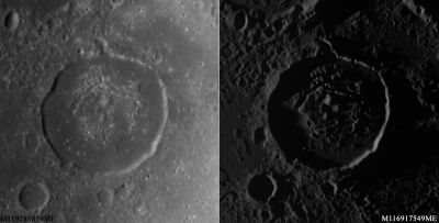
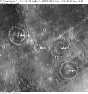
| − | '''Left:''' Two ''[http://lroc.sese.asu.edu/index.html LROC]'' views of '''Warner''' under diffferent lighting conditions (WAC Nos. [http://wms.lroc.asu.edu/lroc/view_lroc/LRO-L-LROC-2-EDR-V1.0/M119285839ME M119285839ME] and [http://wms.lroc.asu.edu/lroc/view_lroc/LRO-L-LROC-2-EDR-V1.0/M116917549ME M116917549ME]. Calibrated by [http://ltvt.wikispaces.com/Utility%20Programs#WAC_Viewer LROC_WAC_Previewer].<br /> '''Right:''' ''[http://lpod.org/coppermine/displayimage.php?pos=-2732 LO-IV-009M]'' This is an area that is poorly represented in any of the [ | + | '''Left:''' Two ''[http://lroc.sese.asu.edu/index.html LROC]'' views of '''Warner''' under diffferent lighting conditions (WAC Nos. [http://wms.lroc.asu.edu/lroc/view_lroc/LRO-L-LROC-2-EDR-V1.0/M119285839ME M119285839ME] and [http://wms.lroc.asu.edu/lroc/view_lroc/LRO-L-LROC-2-EDR-V1.0/M116917549ME M116917549ME]. Calibrated by [http://ltvt.wikispaces.com/Utility%20Programs#WAC_Viewer LROC_WAC_Previewer].<br /> '''Right:''' ''[http://lpod.org/coppermine/displayimage.php?pos=-2732 LO-IV-009M]'' This is an area that is poorly represented in any of the [[Lunar%20Orbiter|Lunar Orbiter]] images that are readily available on-line. The IAU-named features visible in this rectified version of a photo taken with the medium resolution camera are: [[Haldane|Haldane]], [[Talbot|Talbot]], [[Runge|Runge]], and [[Warner|Warner]]. <br /> <div id="toc"> |
| − | + | <br /> | |
| − | |||
==Images== | ==Images== | ||
[http://www.lpod.org/coppermine/thumbnails.php?album=search&type=full&search=Warner LPOD Photo Gallery] [http://www.lpi.usra.edu/resources/lunar_orbiter/bin/srch_nam.shtml?Warner%7C0 Lunar Orbiter Images] [http://www.lpi.usra.edu/resources/apollo/search/feature/?feature=Warner Apollo Images] [http://www.mapaplanet.org/explorer-bin/imageMaker.cgi?version=1.1.1&request=GetMap&map=Moon&Layers=moon_clementine_bw&srs=IAU2000:30174&format=image/jpg&height=250&width=250&bbox=86.1,-5.2,88.5,-2.8&resamp_method=nearest_neighbor Web Map Service]<br /> - '''Warner''' was captured on oblique north-looking color ''Hasselblad'' frames made during the mission of Apollo 14 in february 1971. Frames [http://www.lpi.usra.edu/resources/apollo/frame/?AS14-72-10025 AS14-72-10025] and [http://www.lpi.usra.edu/resources/apollo/frame/?AS14-72-10026 AS14-72-10026] show '''Warner''' in the foreground and nearby '''Runge''' in the background.<br /> - Research Apollo 14 photography: Danny Caes<br /> <br /> | [http://www.lpod.org/coppermine/thumbnails.php?album=search&type=full&search=Warner LPOD Photo Gallery] [http://www.lpi.usra.edu/resources/lunar_orbiter/bin/srch_nam.shtml?Warner%7C0 Lunar Orbiter Images] [http://www.lpi.usra.edu/resources/apollo/search/feature/?feature=Warner Apollo Images] [http://www.mapaplanet.org/explorer-bin/imageMaker.cgi?version=1.1.1&request=GetMap&map=Moon&Layers=moon_clementine_bw&srs=IAU2000:30174&format=image/jpg&height=250&width=250&bbox=86.1,-5.2,88.5,-2.8&resamp_method=nearest_neighbor Web Map Service]<br /> - '''Warner''' was captured on oblique north-looking color ''Hasselblad'' frames made during the mission of Apollo 14 in february 1971. Frames [http://www.lpi.usra.edu/resources/apollo/frame/?AS14-72-10025 AS14-72-10025] and [http://www.lpi.usra.edu/resources/apollo/frame/?AS14-72-10026 AS14-72-10026] show '''Warner''' in the foreground and nearby '''Runge''' in the background.<br /> - Research Apollo 14 photography: Danny Caes<br /> <br /> | ||
==Maps== | ==Maps== | ||
| − | ''([ | + | ''([[LAC%20zone|LAC zone]] 81B3)'' [http://www.lpi.usra.edu/resources/mapcatalog/LTO/lto81b3_1/ LTO map]<br /> <br /> |
==Description== | ==Description== | ||
<br /> | <br /> | ||
| Line 23: | Line 22: | ||
==Additional Information== | ==Additional Information== | ||
* IAU page: [http://planetarynames.wr.usgs.gov/Feature/6489 Warner] | * IAU page: [http://planetarynames.wr.usgs.gov/Feature/6489 Warner] | ||
| − | * Depth data from [ | + | * Depth data from [[Kurt%20Fisher%20Crater%20Depths|Kurt Fisher database]] |
** Pike, 1976: 0.25 km | ** Pike, 1976: 0.25 km | ||
** Westfall, 2000: 0.25 km | ** Westfall, 2000: 0.25 km | ||
| Line 30: | Line 29: | ||
Worcester Reed; American inventor (1846-1929).<br /> | Worcester Reed; American inventor (1846-1929).<br /> | ||
| − | * This name appears on [http://www.lpi.usra.edu/resources/mapcatalog/LTO/lto81b3_1/ LTO-81B3]. It does not appear to replace any previous IAU-approved designation. Although it appears in the cumulative list of approved names printed in [ | + | * This name appears on [http://www.lpi.usra.edu/resources/mapcatalog/LTO/lto81b3_1/ LTO-81B3]. It does not appear to replace any previous IAU-approved designation. Although it appears in the cumulative list of approved names printed in [[IAU%20Transactions%20XVB|IAU Transactions XVB]], when and how it came to be approved is not entirely clear from the IAU record. <span class="membersnap">- JimMosher</span> |
<br /> | <br /> | ||
==LPOD Articles== | ==LPOD Articles== | ||
| − | [http:// | + | [http://www2.lpod.org/wiki/January_13,_2007 Deep, Young and Ashy]<br /> <br /> |
==Bibliography== | ==Bibliography== | ||
<br /> <br /> | <br /> <br /> | ||
---- | ---- | ||
| − | [ | + | [[Alphabetical%20Index|Named Features]] -- Prev: [[Wargentin|Wargentin]] -- Next: [[Waterman|Waterman]]<br /> |
---- | ---- | ||
| − | + | </div> | |
Latest revision as of 20:45, 16 April 2018
Contents
Warner
|
Lat: 4.02°S, Long: 87.33°E, Diam: 34.83 km, Depth: 0.25 km, Rükl: 49 | |
Right: LO-IV-009M This is an area that is poorly represented in any of the Lunar Orbiter images that are readily available on-line. The IAU-named features visible in this rectified version of a photo taken with the medium resolution camera are: Haldane, Talbot, Runge, and Warner.
Images
LPOD Photo Gallery Lunar Orbiter Images Apollo Images Web Map Service
- Warner was captured on oblique north-looking color Hasselblad frames made during the mission of Apollo 14 in february 1971. Frames AS14-72-10025 and AS14-72-10026 show Warner in the foreground and nearby Runge in the background.
- Research Apollo 14 photography: Danny Caes
Maps
Description
Wikipedia
Additional Information
- IAU page: Warner
- Depth data from Kurt Fisher database
- Pike, 1976: 0.25 km
- Westfall, 2000: 0.25 km
Nomenclature
Worcester Reed; American inventor (1846-1929).
- This name appears on LTO-81B3. It does not appear to replace any previous IAU-approved designation. Although it appears in the cumulative list of approved names printed in IAU Transactions XVB, when and how it came to be approved is not entirely clear from the IAU record. - JimMosher
LPOD Articles
Bibliography
Named Features -- Prev: Wargentin -- Next: Waterman

