Difference between revisions of "Delambre"
(Created page with "<div id="content_view" class="wiki" style="display: block"> =Delambre= {| class="wiki_table" | Lat: 1.9°S, Long: 17.5°E, Diam: 51 km, Depth: 3.62 km, [http://the-moon.wi...") |
|||
| Line 3: | Line 3: | ||
{| class="wiki_table" | {| class="wiki_table" | ||
| | | | ||
| − | Lat: 1.9°S, Long: 17.5°E, Diam: 51 km, Depth: 3.62 km, [http://the-moon. | + | Lat: 1.9°S, Long: 17.5°E, Diam: 51 km, Depth: 3.62 km, [http://the-moon.us/wiki/R%C3%BCkl%2046 Rükl: 46]<br /> |
|} | |} | ||
<div id="toc"> | <div id="toc"> | ||
| Line 11: | Line 11: | ||
[http://www.lpod.org/coppermine/thumbnails.php?album=search&type=full&search=Delambre LPOD Photo Gallery] [http://www.lpi.usra.edu/resources/lunar_orbiter/bin/srch_nam.shtml?Delambre%7C0 Lunar Orbiter Images] [http://www.lpi.usra.edu/resources/apollo/search/feature/?feature=Delambre Apollo Images]<br /> [http://www.lpi.usra.edu/resources/ranger/catalog/8/A/ Ranger 8 - Camera A photographs]<br /> [http://www.lpi.usra.edu/resources/ranger/catalog/8/B/ Ranger 8 - Camera B photographs] of which [http://www.lpi.usra.edu/resources/ranger/frame/?msn=8&cam=B&plt=30 Frame B030] shows '''Delambre''' in the lower left corner of the photograph.<br /> An interesting close up of '''Delambre''''s northern half was made by ''Lunar Orbiter 3'', [http://www.lpi.usra.edu/resources/lunarorbiter/frame/?3079 Frame 3079].<br /> Research: Danny Caes<br /> <br /> | [http://www.lpod.org/coppermine/thumbnails.php?album=search&type=full&search=Delambre LPOD Photo Gallery] [http://www.lpi.usra.edu/resources/lunar_orbiter/bin/srch_nam.shtml?Delambre%7C0 Lunar Orbiter Images] [http://www.lpi.usra.edu/resources/apollo/search/feature/?feature=Delambre Apollo Images]<br /> [http://www.lpi.usra.edu/resources/ranger/catalog/8/A/ Ranger 8 - Camera A photographs]<br /> [http://www.lpi.usra.edu/resources/ranger/catalog/8/B/ Ranger 8 - Camera B photographs] of which [http://www.lpi.usra.edu/resources/ranger/frame/?msn=8&cam=B&plt=30 Frame B030] shows '''Delambre''' in the lower left corner of the photograph.<br /> An interesting close up of '''Delambre''''s northern half was made by ''Lunar Orbiter 3'', [http://www.lpi.usra.edu/resources/lunarorbiter/frame/?3079 Frame 3079].<br /> Research: Danny Caes<br /> <br /> | ||
==Maps== | ==Maps== | ||
| − | ''([http://the-moon. | + | ''([http://the-moon.us/wiki/LAC%20zone LAC zone] 78A2)'' [http://www.lpi.usra.edu/resources/mapcatalog/LAC/lac78/ LAC map] [http://www.lpi.usra.edu/resources/mapcatalog/usgs/I546/ Geologic map] [http://www.lpi.usra.edu/resources/mapcatalog/LM/lm78/ LM map] [http://www.lpi.usra.edu/resources/mapcatalog/AIC/AIC78A/ AIC map]<br /> <br /> |
==Description== | ==Description== | ||
<br /> | <br /> | ||
==Description: Elger== | ==Description: Elger== | ||
| − | ''([http://the-moon. | + | ''([http://the-moon.us/wiki/IAU%20Directions IAU Directions])'' DELAMBRE.--A conspicuous ring-plain, 32 miles in diameter, a little S. of the equator, in E. long. 17 deg. 30 min., with a massive polygonal border, terraced within, rising on the E. to the great height of 15,000 feet above the interior, but to little more than half this on the opposite side. Its outline approximates to that of a pentagon with slightly curved sides. A section on the S.W. exhibits an inflexion towards the centre. The crest is everywhere continuous except on the N., where it is broken by a deep crater with a bright rim. The north-westerly trend of the ridges and hillocks on the W. is especially noteworthy. The central peak is not prominent, but close under it on the W. is a deep fissure, extending from near the centre, and dying out before it reaches the S. border. At the foot of the N.W. <u>glacis</u> there are traces of a ring with low walls.<br /> <br /> |
==Description: Wikipedia== | ==Description: Wikipedia== | ||
[http://en.wikipedia.org/wiki/Delambre_(crater) Delambre]<br /> <br /> | [http://en.wikipedia.org/wiki/Delambre_(crater) Delambre]<br /> <br /> | ||
==Additional Information== | ==Additional Information== | ||
| − | Depth data from [http://the-moon. | + | Depth data from [http://the-moon.us/wiki/Kurt%20Fisher%20crater%20depths Kurt Fisher database]<br /> |
* Westfall, 2000: 3.62 km | * Westfall, 2000: 3.62 km | ||
* Viscardy, 1985: 3.5 km | * Viscardy, 1985: 3.5 km | ||
| Line 27: | Line 27: | ||
* Named for [http://en.wikipedia.org/wiki/Jean_Baptiste_Joseph_Delambre Jean Baptiste Joseph Delambre] (September 19, 1749 in Amiens – August 19, 1822 in Paris), a French mathematician and astronomer. Named director of the Paris Observatory and professor at the Collège de France, Delambre was one of the first astronomers to derive astronomical equations from analytical formulas, was the author of ''Delambre's Analogies'' and, after the age of 70, also the author of works on the history of astronomy. | * Named for [http://en.wikipedia.org/wiki/Jean_Baptiste_Joseph_Delambre Jean Baptiste Joseph Delambre] (September 19, 1749 in Amiens – August 19, 1822 in Paris), a French mathematician and astronomer. Named director of the Paris Observatory and professor at the Collège de France, Delambre was one of the first astronomers to derive astronomical equations from analytical formulas, was the author of ''Delambre's Analogies'' and, after the age of 70, also the author of works on the history of astronomy. | ||
| − | * This name was one of eight names introduced by [http://the-moon. | + | * This name was one of eight names introduced by [http://the-moon.us/wiki/Lohrmann Lohrmann] (''[http://the-moon.us/wiki/Whitaker Whitaker]'', p. 119). All of Lohrmann's names were adopted by the three "authorities" cited in Mary Blagg's ''[http://the-moon.us/wiki/Collated%20List Collated List]'', and incorporated into the original [http://the-moon.us/wiki/IAU%20nomenclature IAU nomenclature] of [http://the-moon.us/wiki/Blagg%20and%20M%C3%BCller Blagg and Müller] (1935). |
* '''Delambre Epsilon''' (elevation south of '''Delambre''') (see page 123 in Tony Dethier's ''Maanmonografieen'') (the name '''Delambre Epsilon''' is not mentioned on Chart 57 in the ''Times Atlas of the Moon''). | * '''Delambre Epsilon''' (elevation south of '''Delambre''') (see page 123 in Tony Dethier's ''Maanmonografieen'') (the name '''Delambre Epsilon''' is not mentioned on Chart 57 in the ''Times Atlas of the Moon''). | ||
<br /> | <br /> | ||
==LPOD Articles== | ==LPOD Articles== | ||
| − | [http:// | + | [http://www2.lpod.org/wiki/December_19,_2006 A Gray Day.] [http://www2.lpod.org/wiki/December_11,_2006 How Deep is that Hole?] [http://www2.lpod.org/wiki/January_25,_2006 Subtle Lineations]<br /> <br /> |
==Bibliography== | ==Bibliography== | ||
<br /> <br /> | <br /> <br /> | ||
---- | ---- | ||
This page has been edited 1 times. The last modification was made by <span class="membersnap">- [http://www.wikispaces.com/user/view/tychocrater [[Image:tychocrater-lg.jpg|16px|tychocrater]]] [http://www.wikispaces.com/user/view/tychocrater tychocrater]</span> on Jun 13, 2009 3:24 pm - ''afx3u2''</div> | This page has been edited 1 times. The last modification was made by <span class="membersnap">- [http://www.wikispaces.com/user/view/tychocrater [[Image:tychocrater-lg.jpg|16px|tychocrater]]] [http://www.wikispaces.com/user/view/tychocrater tychocrater]</span> on Jun 13, 2009 3:24 pm - ''afx3u2''</div> | ||
Revision as of 19:12, 11 April 2018
Contents
Delambre
|
Lat: 1.9°S, Long: 17.5°E, Diam: 51 km, Depth: 3.62 km, Rükl: 46 |
Table of Contents


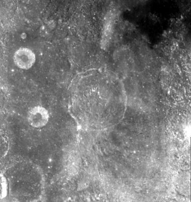
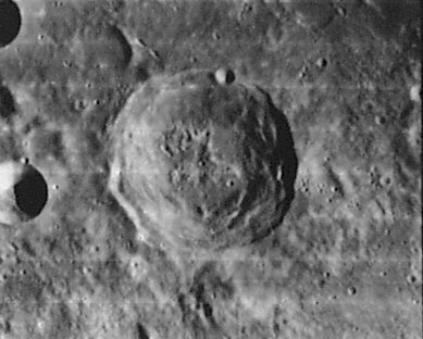
Left: Clementine Right: Lunar Orbiter
Images
LPOD Photo Gallery Lunar Orbiter Images Apollo Images
Ranger 8 - Camera A photographs
Ranger 8 - Camera B photographs of which Frame B030 shows Delambre in the lower left corner of the photograph.
An interesting close up of Delambre's northern half was made by Lunar Orbiter 3, Frame 3079.
Research: Danny Caes
Maps
(LAC zone 78A2) LAC map Geologic map LM map AIC map
Description
Description: Elger
(IAU Directions) DELAMBRE.--A conspicuous ring-plain, 32 miles in diameter, a little S. of the equator, in E. long. 17 deg. 30 min., with a massive polygonal border, terraced within, rising on the E. to the great height of 15,000 feet above the interior, but to little more than half this on the opposite side. Its outline approximates to that of a pentagon with slightly curved sides. A section on the S.W. exhibits an inflexion towards the centre. The crest is everywhere continuous except on the N., where it is broken by a deep crater with a bright rim. The north-westerly trend of the ridges and hillocks on the W. is especially noteworthy. The central peak is not prominent, but close under it on the W. is a deep fissure, extending from near the centre, and dying out before it reaches the S. border. At the foot of the N.W. glacis there are traces of a ring with low walls.
Description: Wikipedia
Additional Information
Depth data from Kurt Fisher database
- Westfall, 2000: 3.62 km
- Viscardy, 1985: 3.5 km
- Cherrington, 1969: 3.5 km
Nomenclature
- Named for Jean Baptiste Joseph Delambre (September 19, 1749 in Amiens – August 19, 1822 in Paris), a French mathematician and astronomer. Named director of the Paris Observatory and professor at the Collège de France, Delambre was one of the first astronomers to derive astronomical equations from analytical formulas, was the author of Delambre's Analogies and, after the age of 70, also the author of works on the history of astronomy.
- This name was one of eight names introduced by Lohrmann (Whitaker, p. 119). All of Lohrmann's names were adopted by the three "authorities" cited in Mary Blagg's Collated List, and incorporated into the original IAU nomenclature of Blagg and Müller (1935).
- Delambre Epsilon (elevation south of Delambre) (see page 123 in Tony Dethier's Maanmonografieen) (the name Delambre Epsilon is not mentioned on Chart 57 in the Times Atlas of the Moon).
LPOD Articles
A Gray Day. How Deep is that Hole? Subtle Lineations
Bibliography
This page has been edited 1 times. The last modification was made by - tychocrater tychocrater on Jun 13, 2009 3:24 pm - afx3u2