Difference between revisions of "Dorsum Von Cotta"
(Created page with "<div id="content_view" class="wiki" style="display: block"> =Dorsum Von Cotta= {| class="wiki_table" | colspan="2" | Lat: 23.2°N, Long: 11.9°E, Length: 199 km, Height: k...") |
|||
| (3 intermediate revisions by the same user not shown) | |||
| Line 3: | Line 3: | ||
{| class="wiki_table" | {| class="wiki_table" | ||
| colspan="2" | | | colspan="2" | | ||
| − | Lat: 23.2°N, Long: 11.9°E, Length: 199 km, Height: km, [ | + | Lat: 23.2°N, Long: 11.9°E, Length: 199 km, Height: km, [[R%C3%BCkl%2023|Rükl: 23]]<br /> |
|- | |- | ||
| | | | ||
| − | [http://www.lpod.org/coppermine/displayimage.php?pid=4869&fullsize=1 [[Image: | + | [http://www.lpod.org/coppermine/displayimage.php?pid=4869&fullsize=1 [[Image:Normal_dorsum-von-cotta2.jpg|external image normal_dorsum-von-cotta2.jpg]]]<br /> |
| | | | ||
| − | [http://www.lpod.org/coppermine/albums/userpics/Dorsum-Von-Cotta_CLA-C11_LTVT.JPG [[Image: | + | [http://www.lpod.org/coppermine/albums/userpics/Dorsum-Von-Cotta_CLA-C11_LTVT.JPG [[Image:Normal_Dorsum-Von-Cotta_CLA-C11_LTVT.JPG|external image normal_Dorsum-Von-Cotta_CLA-C11_LTVT.JPG]]]<br /> |
|} | |} | ||
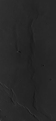
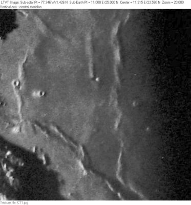
| − | '''Left:''' ''[http://lroc.sese.asu.edu/index.html LROC]'' image WAC No. [http://wms.lroc.asu.edu/lroc/view_lroc/LRO-L-LROC-2-EDR-V1.0/M116241995ME M116241995ME]. Calibrated by [http://ltvt.wikispaces.com/Utility%20Programs#WAC_Viewer LROC_WAC_Previewer].<br /> '''Right:''' ''[http://lpod.org/coppermine/displayimage.php?pos=-2931 Consolidated Lunar Atlas, Plate C11]'' '''Dorsum Von Cotta''' is the north-south ridge to the right of center (closest to the terminator). To its immediate west is the parallel, but much shorter, [ | + | '''Left:''' ''[http://lroc.sese.asu.edu/index.html LROC]'' image WAC No. [http://wms.lroc.asu.edu/lroc/view_lroc/LRO-L-LROC-2-EDR-V1.0/M116241995ME M116241995ME]. Calibrated by [http://ltvt.wikispaces.com/Utility%20Programs#WAC_Viewer LROC_WAC_Previewer].<br /> '''Right:''' ''[http://lpod.org/coppermine/displayimage.php?pos=-2931 Consolidated Lunar Atlas, Plate C11]'' '''Dorsum Von Cotta''' is the north-south ridge to the right of center (closest to the terminator). To its immediate west is the parallel, but much shorter, [[Dorsum%20Owen|Dorsum Owen]], and to the south the diagonal ridge is a part of [[Dorsum%20Buckland|Dorsum Buckland]]. The north-south ridge passing through the crater on the far left is [[Dorsum%20Gast|Dorsum Gast]]. The diagonal ridge above it is unnamed. The original IAU approval of the name '''Dorsum Von Cotta''' “as assigned” on the [[LTO|LTO]] charts would seem to apply only to the upper part, next to [[Dorsum%20Owen|Dorsum Owen]], for that is all that is labeled on the [http://www.lpi.usra.edu/resources/mapcatalog/LTO/lto42a4_2/ LTO]’s and the accompanying [http://www.lpi.usra.edu/resources/mapcatalog/LM/lm42/ LM-42]. However, the position and diameter now given in the on-line [[IAU%20Planetary%20Gazetteer|IAU Planetary Gazetteer]] would seem to include the entire ridge, including possibly the part where it turns sharply to the southeast, paralleling [[Dorsum%20Buckland|Dorsum Buckland]]. That portion of the ridge is clearly depicted, but unlabeled, on [http://www.lpi.usra.edu/resources/mapcatalog/LTO/lto42d1_2/ LTO-42D1].<br /> <div id="toc"> |
| − | + | <br /> | |
| − | |||
==Images== | ==Images== | ||
[http://www.lpod.org/coppermine/thumbnails.php?album=search&type=full&search=Dorsum%20Von%20Cotta LPOD Photo Gallery] [http://www.lpi.usra.edu/resources/lunar_orbiter/bin/srch_nam.shtml?Dorsum%20Von%20Cotta%7C0 Lunar Orbiter Images] [http://www.lpi.usra.edu/resources/apollo/search/feature/?feature=Dorsum%20Von%20Cotta Apollo Images]<br /> <br /> | [http://www.lpod.org/coppermine/thumbnails.php?album=search&type=full&search=Dorsum%20Von%20Cotta LPOD Photo Gallery] [http://www.lpi.usra.edu/resources/lunar_orbiter/bin/srch_nam.shtml?Dorsum%20Von%20Cotta%7C0 Lunar Orbiter Images] [http://www.lpi.usra.edu/resources/apollo/search/feature/?feature=Dorsum%20Von%20Cotta Apollo Images]<br /> <br /> | ||
==Maps== | ==Maps== | ||
| − | ''([ | + | ''([[LAC%20zone|LAC zone]] 42D1)'' [http://www.lpi.usra.edu/resources/mapcatalog/LAC/lac42/ LAC map] [http://www.lpi.usra.edu/resources/mapcatalog/usgs/I489/ Geologic map] [http://www.lpi.usra.edu/resources/mapcatalog/LM/lm42/ LM map] [http://www.lpi.usra.edu/resources/mapcatalog/LTO/lto42a4_2/ LTO (north)][http://www.lpi.usra.edu/resources/mapcatalog/LTO/lto42d1_2/ LTO (south)]<br /> <br /> |
==Description== | ==Description== | ||
<br /> | <br /> | ||
| Line 25: | Line 24: | ||
==Nomenclature== | ==Nomenclature== | ||
Carl Bernard; German Earth scientist (1808-1879).<br /> | Carl Bernard; German Earth scientist (1808-1879).<br /> | ||
| − | * '''Dorsum Von Cotta''' was among the many names approved "as now assigned and printed on the [ | + | * '''Dorsum Von Cotta''' was among the many names approved "as now assigned and printed on the [[LTO|1:250,000 lunar map series]]" (LTO's) in [[IAU%20Transactions%20XVIB|IAU Transactions XVIB]]. Since the southward extension beyond the latitude of [[Aratus%20CA|Aratus CA]] was not labeled as part of '''Dorsum Von Cotta''' on any of the LTO's, or on the accompanying [http://www.lpi.usra.edu/resources/mapcatalog/LM/lm42/ LM-42] it is a bit hard to understand how the position and diameter listed in the on-line [[IAU%20Planetary%20Gazetteer|IAU Planetary Gazetteer]] came to include that area (however logical the extension may seem). <span class="membersnap">- JimMosher</span> |
<br /> | <br /> | ||
==LPOD Articles== | ==LPOD Articles== | ||
| Line 32: | Line 31: | ||
---- | ---- | ||
| − | + | </div> | |
Latest revision as of 20:11, 16 April 2018
Contents
Dorsum Von Cotta
|
Lat: 23.2°N, Long: 11.9°E, Length: 199 km, Height: km, Rükl: 23 | |
Right: Consolidated Lunar Atlas, Plate C11 Dorsum Von Cotta is the north-south ridge to the right of center (closest to the terminator). To its immediate west is the parallel, but much shorter, Dorsum Owen, and to the south the diagonal ridge is a part of Dorsum Buckland. The north-south ridge passing through the crater on the far left is Dorsum Gast. The diagonal ridge above it is unnamed. The original IAU approval of the name Dorsum Von Cotta “as assigned” on the LTO charts would seem to apply only to the upper part, next to Dorsum Owen, for that is all that is labeled on the LTO’s and the accompanying LM-42. However, the position and diameter now given in the on-line IAU Planetary Gazetteer would seem to include the entire ridge, including possibly the part where it turns sharply to the southeast, paralleling Dorsum Buckland. That portion of the ridge is clearly depicted, but unlabeled, on LTO-42D1.
Images
LPOD Photo Gallery Lunar Orbiter Images Apollo Images
Maps
(LAC zone 42D1) LAC map Geologic map LM map LTO (north)LTO (south)
Description
Description: Wikipedia
Additional Information
Nomenclature
Carl Bernard; German Earth scientist (1808-1879).
- Dorsum Von Cotta was among the many names approved "as now assigned and printed on the 1:250,000 lunar map series" (LTO's) in IAU Transactions XVIB. Since the southward extension beyond the latitude of Aratus CA was not labeled as part of Dorsum Von Cotta on any of the LTO's, or on the accompanying LM-42 it is a bit hard to understand how the position and diameter listed in the on-line IAU Planetary Gazetteer came to include that area (however logical the extension may seem). - JimMosher
LPOD Articles

