Difference between revisions of "Schiller-Zucchius Basin"
(Created page with "<div id="content_view" class="wiki" style="display: block"> =Schiller-Zucchius Basin= ''(unofficial name)''<br /> {| class="wiki_table" | Lat: 56.0°S, Long: 45.0°W, Di...") |
|||
| (3 intermediate revisions by the same user not shown) | |||
| Line 4: | Line 4: | ||
{| class="wiki_table" | {| class="wiki_table" | ||
| | | | ||
| − | Lat: 56.0°S, Long: 45.0°W, Diam: 335 km, Depth: km, [ | + | Lat: 56.0°S, Long: 45.0°W, Diam: 335 km, Depth: km, [[R%C3%BCkl%2070|Rükl: 70, 71]]<br /> |
|- | |- | ||
| | | | ||
| − | [http://www.lpod.org/coppermine/displayimage.php?pid=1508&fullsize=1 [[Image: | + | [http://www.lpod.org/coppermine/displayimage.php?pid=1508&fullsize=1 [[Image:Normal_SZ%20Basin%20C%20070511%201001.jpg|external image normal_SZ%20Basin%20C%20070511%201001.jpg]]]<br /> |
| | | | ||
| − | [http://www.lpod.org/coppermine/displayimage.php?pid=2307&fullsize=1 [[Image: | + | [http://www.lpod.org/coppermine/displayimage.php?pid=2307&fullsize=1 [[Image:Normal_Schiller-Zucchius_Basin_LIDAR_LTVT.JPG|external image normal_Schiller-Zucchius_Basin_LIDAR_LTVT.JPG]]]<br /> |
|} | |} | ||
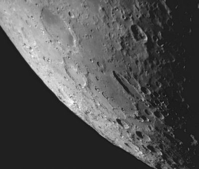
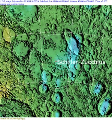
Left: ''[http://lpod.org/coppermine/displayimage.php?pos=-1508 Howard Eskildsen]'', Right: ''[http://lpod.org/coppermine/displayimage.php?pos=-2307 Clementine]'', Clementine LIDAR Altimeter texture from [http://pdsmaps.wr.usgs.gov/PDS/public/explorer/html/lidrlvls.htm PDS Map-a-Planet] remapped to north-up aerial view by [http://www.henriksucla.dk/ LTVT]. The dot is the center position and the white circle the main ring position from Chuck Wood's [http://www.lpod.org/cwm/DataStuff/Lunar%20Basins.htm Impact Basin Database]. Grid spacing = 10 degrees.<br /> <br /> <div id="toc"> | Left: ''[http://lpod.org/coppermine/displayimage.php?pos=-1508 Howard Eskildsen]'', Right: ''[http://lpod.org/coppermine/displayimage.php?pos=-2307 Clementine]'', Clementine LIDAR Altimeter texture from [http://pdsmaps.wr.usgs.gov/PDS/public/explorer/html/lidrlvls.htm PDS Map-a-Planet] remapped to north-up aerial view by [http://www.henriksucla.dk/ LTVT]. The dot is the center position and the white circle the main ring position from Chuck Wood's [http://www.lpod.org/cwm/DataStuff/Lunar%20Basins.htm Impact Basin Database]. Grid spacing = 10 degrees.<br /> <br /> <div id="toc"> | ||
| − | + | ||
| − | |||
==Images== | ==Images== | ||
[http://www.lpod.org/coppermine/thumbnails.php?album=search&type=full&search=Schiller-Zucchius LPOD|Photo Gallery images] [http://www.lpi.usra.edu/resources/lunar_orbiter/bin/srch_nam.shtml?Schiller%7C0 Lunar Orbiter Images]<br /> <br /> | [http://www.lpod.org/coppermine/thumbnails.php?album=search&type=full&search=Schiller-Zucchius LPOD|Photo Gallery images] [http://www.lpi.usra.edu/resources/lunar_orbiter/bin/srch_nam.shtml?Schiller%7C0 Lunar Orbiter Images]<br /> <br /> | ||
==Maps== | ==Maps== | ||
| − | ''([ | + | ''([[LAC%20zone|LAC zone]] 125D1)'' [http://www.lpi.usra.edu/resources/mapcatalog/LAC/lac125/ LAC map] [http://www.lpi.usra.edu/resources/mapcatalog/usgs/I691/ Geologic map] [http://the-moon.us/wiki/SLC-E8 SLC map E8] (''System of Lunar Craters'', 1966).<br /> <br /> |
| − | ==[ | + | ==[[Lunar%20Basins|Basin Classification]]== |
(description of terms and most numeric basin data from Wood, C.A. (2004) [http://www.lpod.org/cwm/DataStuff/Lunar%20Basins.htm Impact Basin Database])<br /> <br /> | (description of terms and most numeric basin data from Wood, C.A. (2004) [http://www.lpod.org/cwm/DataStuff/Lunar%20Basins.htm Impact Basin Database])<br /> <br /> | ||
{| class="wiki_table" | {| class="wiki_table" | ||
| Line 39: | Line 38: | ||
[https://en.wikipedia.org/wiki/Schiller-Zucchius_Basin Schiller-Zucchius Basin]<br /> <br /> | [https://en.wikipedia.org/wiki/Schiller-Zucchius_Basin Schiller-Zucchius Basin]<br /> <br /> | ||
==Additional Information== | ==Additional Information== | ||
| − | I must thank Antoine van der Jeugt, the Flemish connoisseur of telescopic observations of the moon and Mars, and who made me aware of the existence of the '''''Schiller Annular Plain''''' (aka '''Schiller-Zucchius Basin'''). <span class="membersnap">- | + | I must thank Antoine van der Jeugt, the Flemish connoisseur of telescopic observations of the moon and Mars, and who made me aware of the existence of the '''''Schiller Annular Plain''''' (aka '''Schiller-Zucchius Basin'''). <span class="membersnap">- DannyCaes <small>Jan 21, 2017</small></span><br /> <br /> |
==Nomenclature== | ==Nomenclature== | ||
| − | * Basins filled with maria are unofficially named for the mare, and basins that were previously recognized as craters still bear the crater name. Basins located between craters have the names of the two opposite craters with a hyphen in between, in this case [ | + | * Basins filled with maria are unofficially named for the mare, and basins that were previously recognized as craters still bear the crater name. Basins located between craters have the names of the two opposite craters with a hyphen in between, in this case [[Schiller|Schiller]] and [[Zucchius|Zucchius]]. |
* As described in Hartmann and Kuiper (1962), this feature was originally referred to in the literature as "'''basin near Schiller'''". | * As described in Hartmann and Kuiper (1962), this feature was originally referred to in the literature as "'''basin near Schiller'''". | ||
| − | * The [ | + | * The [[BAA|BAA]]'s John Rogers suggested the unofficial name '''Schiller Annular Plain''' in 1976. |
* The much more widely used unofficial name '''Schiller-Zucchius Basin''' appears to have been introduced by Wilhelms, Howard and Wilshire (1979). | * The much more widely used unofficial name '''Schiller-Zucchius Basin''' appears to have been introduced by Wilhelms, Howard and Wilshire (1979). | ||
| − | * 19th century British observers regarded some of the ridges in the '''Schiller-Zucchius Basin''' (specifically those between [ | + | * 19th century British observers regarded some of the ridges in the '''Schiller-Zucchius Basin''' (specifically those between [[Segner|Segner]] and [[Zucchius|Zucchius]]) as comprising a distinct "walled plain" for which Birt suggested the name [[Rosse|Rosse]] (now used for a completely different feature). |
<br /> | <br /> | ||
==LPOD Articles== | ==LPOD Articles== | ||
| − | [http:// | + | [http://www2.lpod.org/wiki/May_12,_2004 A Basin Near Schiller] [http://www2.lpod.org/wiki/October_17,_2004 Rounding the Ellipses] [http://www2.lpod.org/wiki/October_24,_2006 SW TAPER]<br /> <br /> |
==Lunar 100== | ==Lunar 100== | ||
| − | [ | + | [[Lunar%20100|L59]]: Badly degraded overlooked basin.<br /> <br /> |
==Bibliography== | ==Bibliography== | ||
| Line 58: | Line 57: | ||
<br /> <br /> | <br /> <br /> | ||
---- | ---- | ||
| − | + | </div> | |
Latest revision as of 02:16, 16 April 2018
Contents
Schiller-Zucchius Basin
(unofficial name)
|
Lat: 56.0°S, Long: 45.0°W, Diam: 335 km, Depth: km, Rükl: 70, 71 | |
Images
LPOD|Photo Gallery images Lunar Orbiter Images
Maps
(LAC zone 125D1) LAC map Geologic map SLC map E8 (System of Lunar Craters, 1966).
Basin Classification
(description of terms and most numeric basin data from Wood, C.A. (2004) Impact Basin Database)
| Certainty of Existence |
USGS Age |
Wilhelms Age Group |
Ring Diameters |
Mare Thickness |
Mascon |
| Certain |
pre-Nectarian |
7 |
175, 335 km |
0.9 km |
Yes, 14 mG gravity anomaly |
Description Wikipedia
Additional Information
I must thank Antoine van der Jeugt, the Flemish connoisseur of telescopic observations of the moon and Mars, and who made me aware of the existence of the Schiller Annular Plain (aka Schiller-Zucchius Basin). - DannyCaes Jan 21, 2017
Nomenclature
- Basins filled with maria are unofficially named for the mare, and basins that were previously recognized as craters still bear the crater name. Basins located between craters have the names of the two opposite craters with a hyphen in between, in this case Schiller and Zucchius.
- As described in Hartmann and Kuiper (1962), this feature was originally referred to in the literature as "basin near Schiller".
- The BAA's John Rogers suggested the unofficial name Schiller Annular Plain in 1976.
- The much more widely used unofficial name Schiller-Zucchius Basin appears to have been introduced by Wilhelms, Howard and Wilshire (1979).
- 19th century British observers regarded some of the ridges in the Schiller-Zucchius Basin (specifically those between Segner and Zucchius) as comprising a distinct "walled plain" for which Birt suggested the name Rosse (now used for a completely different feature).
LPOD Articles
A Basin Near Schiller Rounding the Ellipses SW TAPER
Lunar 100
L59: Badly degraded overlooked basin.
Bibliography
- Hartmann. W. K., and Kuiper, G. P., 1962, Concentric structures surrounding lunar basins. University of Arizona Lunar and Planetary Laboratory Communications, v. 1, no. 12, p. 51–66.
- Rogers, J. H. 1976. The largest crater on the face of the moon. British Astronomical Association, Journal, vol. 86, Oct. 1976, p. 471-474.
- Wilhelms, D. E., Howard, K. A. and Wilshire, H. G. 1979. Geologic Map of the South Side of the Moon. U.S. Geological Survey map I-1162.

