Difference between revisions of "Korolev"
| Line 5: | Line 5: | ||
| Lat: 4.14°S, Long: 157.22°W, Main ring diam: 440 km, Basin depth: 4.6-5.4 km, Rükl: ''(farside)''<br /> | | Lat: 4.14°S, Long: 157.22°W, Main ring diam: 440 km, Basin depth: 4.6-5.4 km, Rükl: ''(farside)''<br /> | ||
|} | |} | ||
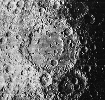
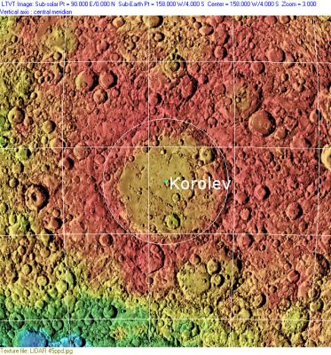
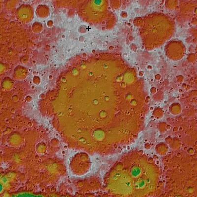
| − | [[Image: | + | [[Image:Normal_korolev-lo-i_038_m.jpg|external image normal_korolev-lo-i_038_m.jpg]][http://www.lpod.org/coppermine/displayimage.php?pid=2309&fullsize=1 [[Image:Normal_Korolev_Basin_LIDAR_LTVT.JPG|external image normal_Korolev_Basin_LIDAR_LTVT.JPG]]][[Image:Korolev.jpg|Korolev.jpg]]<br /> Left: ''[http://lpod.org/coppermine/displayimage.php?pos=-1581 LOI-038-M]'', Middle: ''[http://lpod.org/coppermine/displayimage.php?pos=-2309 LIDAR Altimeter]'', Clementine LIDAR Altimeter texture from [http://pdsmaps.wr.usgs.gov/PDS/public/explorer/html/lidrlvls.htm PDS Map-a-Planet] remapped to north-up aerial view by [http://www.henriksucla.dk/ LTVT]. The dot is the center position and the white circle the main ring position from Chuck Wood's [http://www.lpod.org/cwm/DataStuff/Lunar%20Basins.htm Impact Basin Database].<br /> Right: ''[http://target.lroc.asu.edu/da/qmap.html LROC]'' cross indicates highest point on the Moon (10.786 mts) [http://lroc.sese.asu.edu/news/index.php?/archives/302-Highest-Point-on-the-Moon!.html coordinates] 5.4°N 201.4°E<br /> <br /> <div id="toc"> |
==Images== | ==Images== | ||
| Line 49: | Line 49: | ||
* [https://planetarynames.wr.usgs.gov/Feature/15612 Korolev Z] was officially approved by the IAU on the 25 July 2017 <span class="membersnap">- [http://www.wikispaces.com/user/view/JohnMoore2 [[Image:JohnMoore2-lg.jpg|16px|JohnMoore2]]] [http://www.wikispaces.com/user/view/JohnMoore2 JohnMoore2]</span> | * [https://planetarynames.wr.usgs.gov/Feature/15612 Korolev Z] was officially approved by the IAU on the 25 July 2017 <span class="membersnap">- [http://www.wikispaces.com/user/view/JohnMoore2 [[Image:JohnMoore2-lg.jpg|16px|JohnMoore2]]] [http://www.wikispaces.com/user/view/JohnMoore2 JohnMoore2]</span> | ||
* The IAU crater name honors [http://en.wikipedia.org/wiki/Sergey_Korolyov Sergey Pavlovich Korolyov](January 12, 1907 – January 14, 1966), the head Soviet rocket engineer and designer during the Space Race between the United States and the Soviet Union in the 1950s and 1960s. His name is also sometimes transliterated as Sergei Korolev, thus the spelling used for this crater. Before his death, he was often referred to only as "Chief Designer", because his pivotal role in the Soviet space program had been held to be a state secret by the Politburo. | * The IAU crater name honors [http://en.wikipedia.org/wiki/Sergey_Korolyov Sergey Pavlovich Korolyov](January 12, 1907 – January 14, 1966), the head Soviet rocket engineer and designer during the Space Race between the United States and the Soviet Union in the 1950s and 1960s. His name is also sometimes transliterated as Sergei Korolev, thus the spelling used for this crater. Before his death, he was often referred to only as "Chief Designer", because his pivotal role in the Soviet space program had been held to be a state secret by the Politburo. | ||
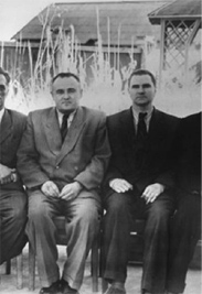
| − | ** Image below is of Korolev (on left, with Valentin [http://the-moon.us/wiki/Glushko Glushko] sitting next to him).<br /> [[Image: | + | ** Image below is of Korolev (on left, with Valentin [http://the-moon.us/wiki/Glushko Glushko] sitting next to him).<br /> [[Image:Glushko-korolev.jpg|glushko-korolev.jpg]]<br /> Credit: NASA (''[http://web.mit.edu/slava/homepage/articles/Gerovitch-Stalins-Rocket-Designers.pdf Chief Designers 1959]'') <span class="membersnap">- [http://www.wikispaces.com/user/view/JohnMoore2 [[Image:JohnMoore2-lg.jpg|16px|JohnMoore2]]] [http://www.wikispaces.com/user/view/JohnMoore2 JohnMoore2] <small>Jun 2, 2011</small></span>. |
* '''Korolev''' was among the long list of farside names approved by the IAU in 1970 and published in [http://the-moon.us/wiki/Menzel%2C%201971#KOROLEV Menzel, 1971]. | * '''Korolev''' was among the long list of farside names approved by the IAU in 1970 and published in [http://the-moon.us/wiki/Menzel%2C%201971#KOROLEV Menzel, 1971]. | ||
** The name was originally bestowed on a feature that was later found to be a basin; pedantically, there is no '''Korolov crater'''. | ** The name was originally bestowed on a feature that was later found to be a basin; pedantically, there is no '''Korolov crater'''. | ||
Revision as of 01:56, 16 April 2018
Contents
Korolev Basin
(unofficial name; IAU crater name: Korolev, 423.41 km diam)
| Lat: 4.14°S, Long: 157.22°W, Main ring diam: 440 km, Basin depth: 4.6-5.4 km, Rükl: (farside) |


Left: LOI-038-M, Middle: LIDAR Altimeter, Clementine LIDAR Altimeter texture from PDS Map-a-Planet remapped to north-up aerial view by LTVT. The dot is the center position and the white circle the main ring position from Chuck Wood's Impact Basin Database.
Right: LROC cross indicates highest point on the Moon (10.786 mts) coordinates 5.4°N 201.4°E
Images
LPOD Photo Gallery Lunar Orbiter Images Apollo Images
- Part of Korolev is seen in David Woods' and Frank O'Brien's assembled PAN 1, made of images AS08-12-2044 to 2075, for their Apollo 8 Flight Journal.
Maps
(LAC zone 87B4) USGS Digital Atlas PDF
Basin Classification
(description of terms and most numeric basin data from Wood, C.A. (2004) Impact Basin Database)
| Certainty of Existence |
USGS Age |
Wilhelms Age Group |
Ring Diameters |
Mare Thickness |
Mascon |
| Definite |
Nectarian |
10 |
220, 440, 590, 810 km |
1.5 |
No; -30 mG gravity anomaly |
Description
Wikipedia
Additional Information
- IAU page: Korolev
- Cook et al. (2002) reported the highest point of the Moon at +9.5 km on the NW rim of Korolev.
- Note: this sounds a bit south of the more recently determined point near Engel'gardt- Jim Mosher
- A curiosity: Orbital Hasselblad image AS08-12-2052, which shows Korolev L (5°30' south/ 157° west) on the floor of Korolev, is one of the most reproduced photographs of a crater on the moon's farside, and it was also used in the episode Survival of the British sci-fi TV-series U.F.O. (by Gerry and Sylvia Anderson, 1970). In that episode, a so-called "UFO" landed somewhere on the moon and was photographed "from a height of 10.000 meter". The so-called "UFO" was the small shadowed crater inside Korolev L.
- Research: Danny Caes.
- The same photograph (AS08-12-2052; Korolev L)(see above) was also used by space artist Robert McCall to create one of his wonderful paintings. See upper painting in Page 3 of Fabio Femino's McCall pages (Fantascienza).
- Korolev X, a small crater at 0°30' North/ 159°30' West, shows a curious dark streak of (what seems to be) a flow (of some sort) on its floor. It (this streak or flow) appears dark on page 138 (LAC 69) of the Clementine Atlas. It's worthwile to explore the LRO's high-resolution photographs of Korolev X on the ACT-REACT Quick Map. Research: Danny Caes
Nomenclature
- Korolev Z was officially approved by the IAU on the 25 July 2017 - JohnMoore2 JohnMoore2
- The IAU crater name honors Sergey Pavlovich Korolyov(January 12, 1907 – January 14, 1966), the head Soviet rocket engineer and designer during the Space Race between the United States and the Soviet Union in the 1950s and 1960s. His name is also sometimes transliterated as Sergei Korolev, thus the spelling used for this crater. Before his death, he was often referred to only as "Chief Designer", because his pivotal role in the Soviet space program had been held to be a state secret by the Politburo.
- Image below is of Korolev (on left, with Valentin Glushko sitting next to him).

Credit: NASA (Chief Designers 1959) - JohnMoore2 JohnMoore2 Jun 2, 2011.
- Image below is of Korolev (on left, with Valentin Glushko sitting next to him).
- Korolev was among the long list of farside names approved by the IAU in 1970 and published in Menzel, 1971.
- The name was originally bestowed on a feature that was later found to be a basin; pedantically, there is no Korolov crater.
- Korolyov famously died during surgery, although the full story was shrouded in mystery for years. An early explanation to leak out of the Soviet Union was that the doctor was drunk and was killed after his patient died. After the fall of the Soviet Union, talk was more free, and Korolyov's family stated that his surgery was conducted well, but uncovered a large intestinal tumor. His health weakened by an aggressive work schedule (and previous years spent in the Gulag), Korolyov died when his heart failed after massive blood loss during the surgery. In any event, Korolyov's untimely death probably assured the US of being first on the Moon. - tychocrater Jul 7, 2007,
- In the planning for Apollo 8, the first manned circumlunar mission (1968), this basin (which did not then have an official name) was referred to informally as America (source: Phil Stooke's LPOD).
- The elongated crater southwest of Korolev L was nicknamed The Keyhole during the mission of Apollo 8 in december 1968. Source: Apollo 8 Flight Journal by David Woods and Frank O'Brien. See: PAN 1.
- Korolev C, a pronounced crater on the northeastern part of Korolev itself, was called Bakhchivandzhi (N° 65) on the Complete Moon Map 1969 made by the Sternberg Institute. Research: Danny Caes.
LPOD Articles
Bibliography
- Cook, A. C.; Spudis, P. D.; Robinson, M. S.; Watters, T. R. 2002. Lunar Topography and Basins Mapped Using a Clementine Stereo Digital Elevation Model. 33rd Annual Lunar and Planetary Science Conference, March 11-15, 2002, Houston, Texas, abstract no. 1281.
- Geek Counterpoint Blog: Podcast Episode 53 -- Sergey Korolyov, January 12, 2007 - 100th anniversary of the birth of a giant of space exploration.
Named Featues -- Prev: Rimae Kopff -- Next: Kosberg