Toscanelli
Contents
[hide]Toscanelli
(formerly Aristarchus C)
|
Lat: 27.96°N, Long: 47.61°W, Diam: 7.05 km, Depth: 1.3 km, Rükl: 18 |
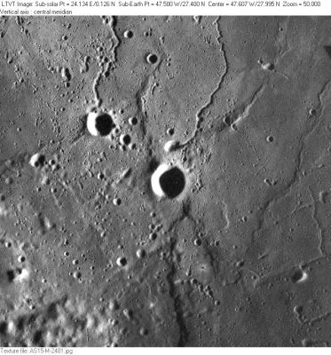
AS15-M-2481 Toscanelli is in the center. The 6-km crater to its upper left is Wollaston N. The rilles are part of Rimae Aristarchus, and the shadow-casting scarp visible at bottom center, and extending north through Toscanelli itself is the northern part of Rupes Toscanelli.
Images
LPOD Photo Gallery Lunar Orbiter Images Apollo Images
Maps
(LAC zone 39A4) LAC map Geologic map LM map LTO map
Description
Wikipedia
Additional Information
- IAU page: Toscanelli
- Depth data from Kurt Fisher database
- Westfall, 2000: 1.3 km
- Toscanelli is listed as a control point in the 1994 and 2005 ULCN where its coordinates are given as Lat: 27.930°N, Long: 47.612°W. Coordinates of Lat: 27.94°N, Long: 47.62°W, Diam: 7.0 km were adopted for use in the IAU Planetary Gazetteer on June 12, 2008. The old position listed there was 0.5° to the south. Toscanelli is one of the first craters for which an attempt has been made to give a selenodetically correct position in the gazetteer (as opposed to one just adequate for identification). The IAU coordinates were subsequently adjusted slightly to conform to the LOLA system. - Jim Mosher
Nomenclature
- Named for Paolo Dal Pozza Toscanelli (1397-1482), an Italian doctor and cartographer.
- This replacement name for a formerly lettered crater first appeared on LTO-39A4. - Jim Mosher
LPOD Articles
Bibliography
Named Features -- Prev: Tortilla Flat -- Next: Rupes Toscanelli
