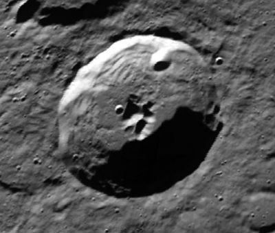
Scoresby
Contents
Scoresby
|
Lat: 77.7°N, Long: 14.1°E, Diam: 55 km, Depth: 4.1 km, Rükl: 4, Eratosthenian |
Images
LPOD Photo Gallery Lunar Orbiter Images
Maps
(LAC zone 4A1) USGS Digital Atlas PDF
Description
Description: Elger
(IAU Directions) SCORESBY.--A much fore-shortened deep ring-plain, 36 miles in diameter, between Barrow and the limb. It has a central mountain with two peaks, which are very difficult to detect.
Description: Wikipedia
Additional Information
- Depth data from Kurt Fisher database
- Westfall, 2000: 4.1 km
- Viscardy, 1985: 2.4 km
- Cherrington, 1969: 3.59 km
- Central peak composition: GNTA1 (Tompkins & Pieters, 1999)
- Central peak height
- [[Sekiguchi, 1972]: 1.3 km* 1.3 km peak immediately to the east of the central peak - fatastronomer**
Nomenclature
William Scoresby (5 October 1789 - 21 March 1857) was an English Arctic explorer, scientist and divine.
Scoresby A was called Sacco by Wilkins and Paluzie-Borrell, but the IAU did not accept that name.
- Sacco was a contemporary Spanish astronomer.
LPOD Articles
Not Santa's Pole.
Over the Pole
Bibliography
- Scoresby A (Sacco): Wilkins and Moore.
- By William Scoresby: -A Description of Some Appearances of Remarkable Rainbows- (Edinburgh New Philosophical Journal, 1827), see Rare Halos, Mirages, Anomalous Rainbows, and related electromagnetic phenomena (William R. Corliss, The Sourcebook Project, 1984).
